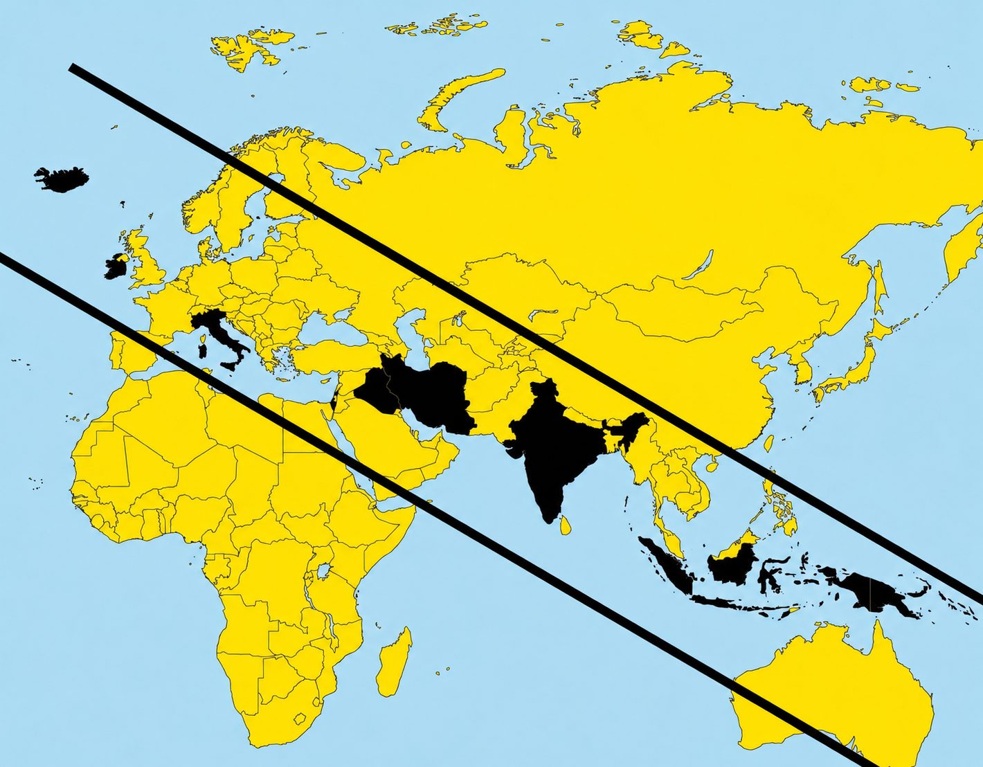
In this image, attention is drawn to the fact that, drawing two parallel lines oblique on a geographical map of the Earth, diagonally, from north-west to south-east, all the states of the world which commonly in Italian begin with the letter “I” fall within the area delimited by the two parallels: Iceland, Ireland, Italy, Israel, Iran, Iraq, India, Indonesia.
A funny visual coincidencewhich, however, depends first of all on the type of map we use, but also on the reference language, and, finally, on the fact that some island states were not taken into consideration (for example the Marshall Islands or the Solomon Islands).
The language considered changes things, but not too much
As we have already said, it is a pure coincidence, and the “game” does not work in all languages. As we can see in the map above, already translating into English, for example, Ivory Coast we obtain Ivory Coast, which in this case falls within the countries that begin with I, although it is not in the range in which we find the other states with I. But the official name is Côte d’Ivoire.
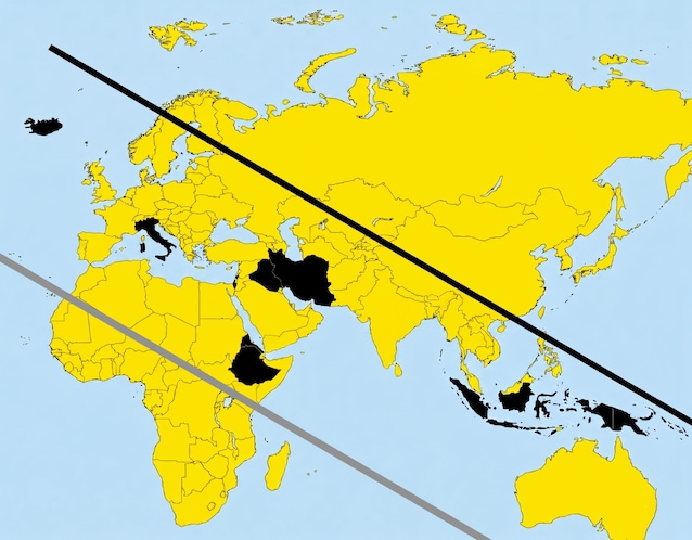
Then wanting to use a more consistent criterion for everyoneit would make sense to consider each country according to the local name and spelling of the respective national language. Given that many states have multiple official languages, many names have multiple transliterations and that some alphabets are not Latin, here is theupdated list of countries which would be included in the list:
- al-Imārāt al-Arabiyyah al-Muttahidah / الإمارات العربيّة المتّحدة = Arabic name for the United Arab Emirates (in Arabic official state names often include certain common nouns, preceded by the article al-)
- Indonesia = Indonesian name for Indonesia
- Īrān / ایران = Persian name for Iran
- al-ʿIrāq / العراق = Arabic name for Iraq (while in Kurdish it is ʿErāq or Ērāq / ێراق or عێراق)
- Iritriyā / إرتريا = Arabic name for Eritrea
- Ísland = Icelandic name for Iceland
- Isra’el (but also Yisrā’el) / ישראל = Hebrew name of Israel (while Isrā’īl / إسرائيل is the Arabic name)
- Italy
- Ityop’iya / ኢትዮጵያ = Amharic name for Ethiopia
The official name ofIndiain Hindi, is Bharat (भारत), often also used in the form Bhārat Gaṇarājya (Republic of India), a term that derives from the ancient Sanskrit language and refers to the land of the descendants of the mythical king Bharata. In Tamil, it is Intiyā (இந்தியா). Let’s say we eliminate India and consider the spelling of Israel with the initial “I”.
The official name of Ireland in Gaelic”Éire“, present in the Constitution since 1937 next to the English version “Ireland”. Therefore considering the Gaelic version, removing Ireland, and adding Eritrea (in Arabic spelling, although Tigrinya and English are also spoken in the country) e Ethiopia (also with multiple languages spoken within it) to the list, we should move the bottom line, lowering it further.
The type of map used
This representation, in any case, uses the Mercator projection: it is one of the most common and well-known maps, in use for centuries. On this map the shapes of the countries are preservedbut the areas depend on the latitude, getting bigger as you get closer to the poles, as the result of a geometric projection to go from 3D to 2D. The surface of a sphere, in fact, cannot be presented on a two-dimensional plane without distortions.
This doesn’t just happen with the Mercator map: in go from three to two dimensions there is always a parameter that undergoes a distortionwhether related to shape, area or distances.
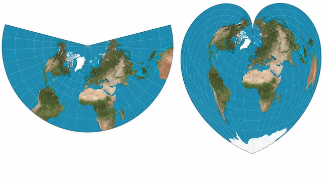
In addition to the Mercator projection, there are other cartographic projections of the world: cylindrical, pseudocylindrical, conic, pseudoconic, azimuthal, polyhedral from the point of view of the geometric classification of the projection, and again, depending on the mathematical/cartographic properties compliant (if they preserve the angles and local shapes), equivalent (if they preserve the relative surfaces), equidistant (if it preserves certain distances), gnomonic (if it represents the paths of the great circle as straight lines), compromise (if it seeks a balance between different distortions without perfectly preserving any property), etc. The Mercator projection is conformal cylindrical.
There is for example the Gall-Peters version (equivalent cylindrical), proposed by James Gall in the 19th century and popularized in the 1970s by Arno Peters to counter the Eurocentric vision of the world: it is one of the variants in which the areas of the countries are respected (at the cost, however, of greatly distorting the shapes).
In the Gall-Peters version the countries would always be placed on a line, but with a different inclination.
In other projections however, like in that one conformal conic by JH Lambert (of 1772), the “visual trick” of the two parallel lines would not work, just as it would not work in the projection Equivalent pseudoconic of Johann Werner.
In short, a coincidence that we can have fun putting to the test.