If there’s one thing we’ve learned the hard way over the past few years, it’s that i summer storms they are no longer what they once were. We are not talking about the classic and refreshing rain that cleans the air, but about real ones stormshailstorms with stones as big as oranges and storms capable of flooding the neighborhoods of a city in a few minutes. Why does this happen? And why the frequency of these episodes is always greater? The scientific answer lies in a single and fundamental word: energy.
To understand what is changing under our sky, we must imagine the atmosphere like a giant heat engine which feeds on heat and humidity. Plus the temperatures on the ground and those of our seas increase, more this engine accumulates a frightening amount of “fuel” ready to explode at the first opportunity.
Meanwhile, Europe is still in the midst of an African heat wave which will last at least until the first week of July, with storms, even very violent, expected in our country.
The role of the heat that accumulates on the ground
Once upon a time, to see a strong storm in Italy, we needed the classic “change of air”that is, the arrival of a massive and structured mass of colder air, capable of displacing the pre-existing heat. Today the situation has radically changed due to global warming. Prolonged subtropical heat waves overheat the land and seas day after day, accumulating a large amount of convective potential energy.
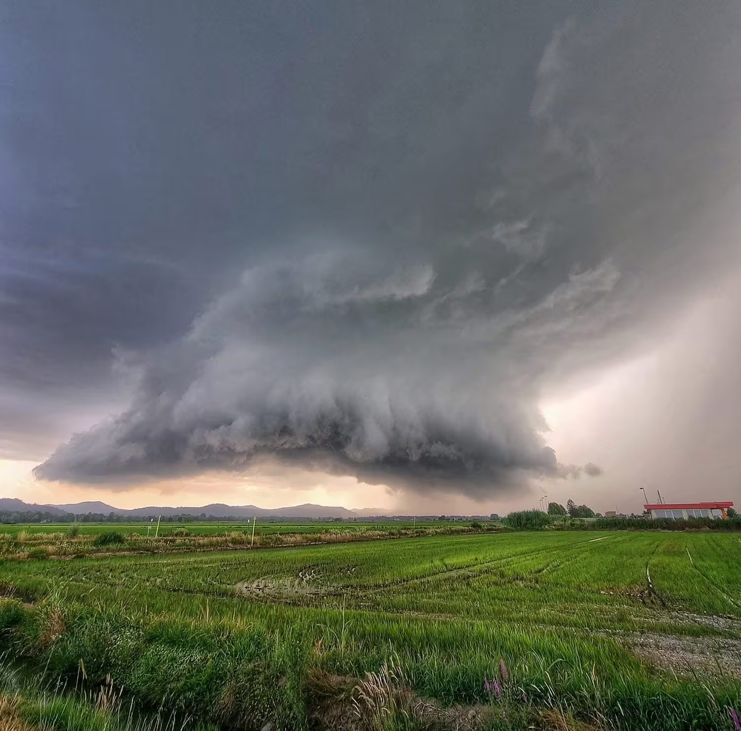
This means that the air near the ground becomes very hot, very light and full of water vapour. When the air is this warm and moist, it tends to rise extremely quickly, just like a hot air balloon does. This process creates ideal conditions for the emergence of very high and dangerous storm clouds, i cumulonimbus cloudswhich can reach and exceed twelve or fourteen kilometers in height.
In Italy thunderstorms like in the tropics
And this is where we enter the heart of the most disturbing and fascinating dynamic of recent times. Once upon a time, in Italy, without a real change of air, there were no strong storms as happens today. Now however, due to the thermal exasperation on the ground, a small breath of fresh air is enough at very high altitude to cause violent thunderstorms to erupt. A real disturbance is not needed: it is sufficient for a very weak flow of slightly cooler air to slide over the column of boiling air accumulated in the lower layers to create an important vertical thermal contrast.
This is exactly what normally happens at tropical and equatorial latitudes. In those areas of the planet there are no cold fronts or seasonal changes as we know them; yet, storms are daily and very violent. The trigger occurs solely because the sun overheats the ground to the point that the air spontaneously rises upwards (convective motions), condensing the humidity present. Italy and the Mediterranean basin are progressively “tropicalizing”, replicating this identical meteorological behavior.
Climate extremes and the price of thermal energy
When this enormous mass of boiling air is caught by the slightest draft at altitude, a real one is generated upward suction. The rising water quickly freezes at sidereal heights and, due to the extremely violent internal currents, the hailstones continue to move “up and down” inside the cloud, growing enormously before falling to the ground due to gravity.
The result is there for all to see. We are not faced with an increase in rainfall, but with one redistribution of the violence of phenomena: the days of useful rain decrease, while individual destructive events increase. Knowing that the heat accumulated on the ground is now capable of generating meteorological monsters even in the absence of real disturbances is a tangible sign of how vital the energy transition and understanding of these new dynamics are for the safety of our territory.