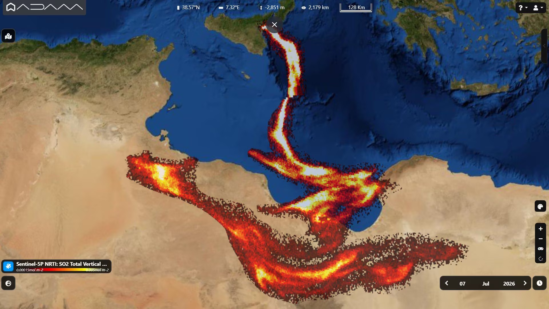
THE’Etna eruption of the beginning July – now concluded – has also been recorded from space: the enormous plume of sulfur dioxide (SO₂) emitted from the Voragine crater was transported by the prevailing winds towards the south, crossing the entire central Mediterranean and reaching the North Africa. This is demonstrated by an image created by the Copernicus Sentinel 5-P satellite and published by the ADAM platform, which clearly shows the plume of volcanic gas extending from Sicily to the coasts of Libya, Tunisia, Algeria and Egypt.
The sulfur dioxide plume and the photo from space by the Copernicus Sentinel-5P satellite
The image you see was captured from space and published by the platform ADAM (Advanced geospatial Data Management): shows a long colored trail that from Sicily crosses the entire central Mediterranean, stretching southwards to the coasts of North Africa. That trail is not smoke in the strict sense, but a huge plume of sulfur dioxide (SO₂) released by Etna during the eruption of 7 July.
It was the satellite that recorded it Sentinel-5Pthe first satellite of the European program Copernicus entirely dedicated to monitoring the Earth’s atmosphere. Launched on 13 October 2017 by the European Space Agency (ESA) and the European Commission, Sentinel-5P is equipped with an instrument called TROPOMES (TROPOspheric Monitoring Instrument), an advanced multispectral spectrometer capable of analyzing the composition of the atmosphere by measuring the distribution of various gases and pollutants: nitrogen dioxide, ozone, carbon monoxide, methane, formaldehyde and, indeed, sulfur dioxide, which is released by a volcano when magma is relatively close to the surface.
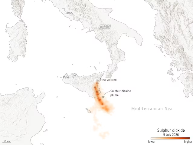
The satellite orbits at 824 km altitude and completes a mapping of the entire planet every day, providing data in near real time. In the case of volcanic eruptions, TROPOMI is able to track SO₂ plumes to monitor their evolution and evaluate their potential effects on air quality and air traffic safety. The image published by ADAM is based precisely on the satellite’s Near Real Time data: the lighter areas correspond to higher concentrations of volcanic gas, and you can clearly see how the plume, transported by the prevailing winds, traveled hundreds of kilometers beyond Sicily until reaching Libya, Tunisia, Algeria and Egypt.
What happened during the eruption of Etna: the INGV bulletins
Etna is, in fact, one of the most active volcanoes in Europe, but the eruption that produced that plume visible from space had a rather complex history. It all started already June 22, 2026when a fracture system had begun to develop at the north-eastern base of the Voragine crater. The June 26thfrom an effusive vent that opened at around 3030 meters above sea level, a lava flow who headed towards the Valle del Leone.
The effusive activity continued for days, feeding a lava field up to 1000 m long 1.2km with an estimated volume of approx 260,000 cubic metersbefore ceasing on July 4. Meanwhile, the Voragine crater had fed a Strombolian activity discontinuous which had gradually intensified. The turning point has arrived Sunday 5 July: starting from the early hours of the morning (around 5:45 UTC, 07:45 in Italy), they began ash emissions from the Voragine crater which rapidly intensified, generating a eruptive cloud approximately 1.5 km high above the top of the volcano.
The explosive activity, which became continuous, was fueled by a new eruptive fissure along the crest of the crater, with several aligned vents that produced both intense Strombolian activity and emission of ash directed southwards, in the direction of Catania. The consequences on the territory were immediate: Catania Fontanarossa airport suffered the closure of airspace and flight restrictions, with hundreds of flights diverted or cancelled.
Starting from the afternoon of July 6as reported by the INGV (National Institute of Geophysics and Volcanology), the explosive and effusive activity has gradually decreased, with the Etna Observatory that the July 7 at 4.01pm confirmed how eruptive activity had significantly decreased since the morning, with the volcanic tremor dropping to the low range. At 10.51 amJuly 8a second statement officially stated the end of the eruptive activity to the Voragine crater: the surveillance cameras no longer showed signs of incandescence or thermal anomalies at the summit craters.
