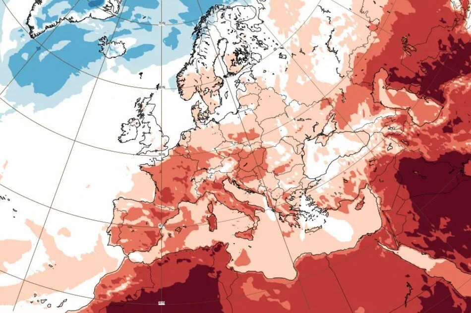
The third heat wave of this summer of 2026 is underway, although it could easily be mistaken as another thermal surge of a single, giant heat bubble that has been gripping us for almost two months. Italy is located inside a “static oven” due to an immense high pressure promontory of continental subtropical matrix, the African anticyclone, with 7 cities to red dot tomorrow, Wednesday 15th, with peaks of 45°C in Sicily, and 15 on Thursday 16th, even if during the a clear change of scenario is expected this weekend starting from the Northern regions, with a change in temperatures, thunderstorms and cloudbursts – the thunderstorms will start as early as tomorrow, in the Triveneto.
But have you ever wondered why this phenomenon is so oppressive and prolonged? It’s not just hot air traveling from the Sahara Desert towards us. The secret lies in a precise thermodynamic mechanism called atmospheric subsidence: the air, crushed towards the ground by the descending motions generated by high pressure, undergoes “adiabatic compression”. It means that the air mass, being compressed due to the weight of the atmospheric column above, warms up and dehumidifies itself, trapping and accumulating heat day after day in the lower layers of the troposphere. The result? A static thermal dome.
An exceptional value: +30°C at 1500 meters above sea level
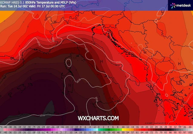
To understand the extent of a heat wave, a fundamental parameter is analyzed: the temperature at the reference altitude 850 hPa (about 1500 meters altitude), useful for estimating the real temperature of the air mass without the influence of direct heating of the ground or orographic variables. Well, these days the cards show a temperature of +30°C at 1500 meters above sea level right above Sardinia. This is an exceptional value, almost unprecedented for the summer climatology of this latitude, which makes it clear how much thermal energy is actually trapped above our heads before even touching the ground.
Ground thermometers: where will the highest temperatures be recorded?
This enormous hot bubble at altitude translates, at sea level, into extremely heavy ground temperatures. Tomorrow the cities with the red sticker for them heat waves there will be 7 (Bologna, Brescia, Florence, Frosinone, Perugia, Rome, Turin) and those with the orange sticker will be 12 (Ancona, Bolzano, Cagliari, Campobasso, Genoa, Latina, Milan, Palermo, Pescara, Rieti, Verona, Viterbo). Thursday July 16th the cities with the red dot will become 15 (to the already mentioned will be added Cagliari, Campobasso, Genoa, Latina, Palermo, Pescara, Rieti and Viterbo); those with an orange sticker will instead drop to five (Bolzano, Milan, Trieste, Venice and Verona).
Here are some of the highest temperatures expected between Tuesday 14th and Friday 17th July: unlike previous heat waves, this time the most extreme peaks will inevitably be concentrated between the South and the Major Islands. The highest temperature ever will be recorded in the internal areas of Sardinia and Sicily. TO Catenanuovain the Enna area, peaks of well will be reached 45°C and remaining on the islands, the plain of Oristano will touch i 41°CWhile Nuoro will even rise to 42°Cwith Carbonia and the coast of Cagliari which will settle on 39-40°C.
Moving on to the peninsular sector, the picture remains hot. In Puglia the city of Foggia could record peaks of 42°Cfollowed by Caltanissetta to 41°C and from Matera to 40°C. Even going back towards Central Italy you will not find respite: the boiling air will bounce into the internal valleys bringing i 40°C to Florence, Terni And Ascoli PicenoWhile Frosinone it will stop just one step below, a 39°C. And the North? In the northern regions the maximum values will settle at apparently lower values, oscillating between 35°C hey 38°Cbut with a fundamental clarification that will completely change the cards on the table, namely a higher humidity level.
The thermal anomaly: our seas are at 30°C
If you think you will find refreshment by taking a dip in the sea, you might be disappointed. The surface temperature of the sea basins around Italy has reached the critical threshold of 28-30°C depending on the area.
Why is this data so relevant from the point of view of thermal physics? Water has a very high specific heat: it accumulates gigantic quantities of heat during the day and releases it extremely slowly. This phenomenon cancels the mitigating effect of the sea. At night, the warm water releases heat to the coastal air, preventing the temperature from dropping. It’s why we’re recording continuously tropical nights or super-tropical nightswith minimum temperatures that do not fall below 25-27 °C and constantly high humidity.
How long will the third heat wave last: the change of scenery from Wednesday 15th
While the Centre-South will be stuck in the grip of the anticyclone, the very first sign of extreme instability will appear as early as mid-week. In the afternoon and evening of Wednesday 15 Julythe Triveneto will enter an area of high storm risk: the models in fact show full scale maps on available convective potential energy (CAPE) and vorticity values. All this could trigger locally violent thunderstorms, with associated large hailstorms and strong gusts of wind.
Returning to look at the national and not regional scenario, according to the simulations of the medium-term models this situation’s days are numbered, at least for a part of Italy. During the a clear change of scenario is expected this weekend starting from the Northern regions. A deep trough of Atlantic origin, filled with cooler and more unstable air, will be able to pierce the northern edge of the anticyclonic dome.
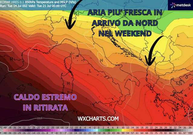
But will the arrival of fresh air wash away the heat without consequences? Unfortunately, the transition will not be at all painless. The incoming cool and dense air will undermine the pre-existing warm-humid air on the ground, pushing it violently upwards. Our seas at 30°C will act as an immense reservoir of water vapor and potential energy for intense storm phenomena, first in the North and then also in the Center and on the Adriatic regions, further away in the South and the Tyrrhenian regions. The first real temperature drop will only be felt from the beginning of next week.
