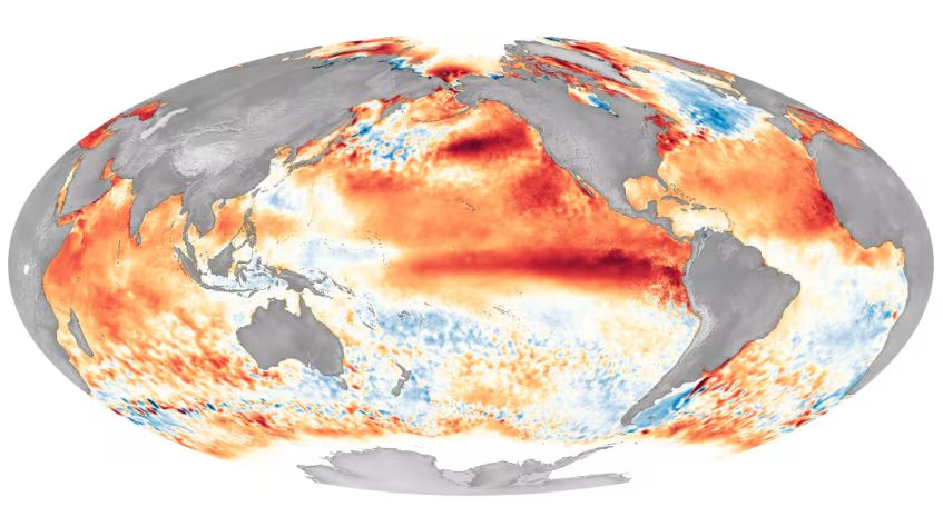
While the seasonal thermal anomalies continue to put various regions of the planet to the test, the eyes of climatologists and meteorologists from all over the world are focused on the dynamics taking place inEquatorial Pacific Ocean. The latest projections developed by the main international calculation centers, such as Severe Weather Europe, indicate that the phenomenon of El Niño is going through a phase of acceleration And intensification exceptional.
Experts hypothesize the formation of a real one Super El Niño with potentially historical characteristics for the winter season 2026/2027with surface thermal anomalies ready to overcome critical thresholds measured only during major events of the past.
Oceanic dynamics and the role of Kelvin waves
To fully understand the scientific significance of this phenomenon it is necessary to observe what is developing outside below the ocean surface. The genesis of an El Niño of this magnitude is triggered by a strong weakening or by a real inversion of the twenty trade windsthe easterly currents that normally push warm waters toward the western Pacific.
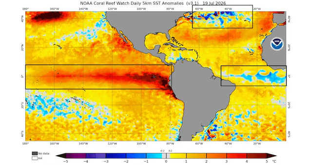
This subsidence allows huge masses of warm water to move eastward in the form of Oceanic Kelvin waves. These waves travel deep along the thermocline belt until they resurface close to the coasts of South America. Once it reaches the surface, the hot water drastically alters the exchange of heat and humidity with the troposphere, covering an area that exceeds 10% of the entire global ocean surface and redistributing energy on a planetary scale.
The severe consequences on the Americas
To suffer the consequences more immediatesevere and largely predictable of a Super El Niño they will be, as usual, the Americas. During the winter season, the enormous heat reservoir accumulated in the central and eastern Pacific strengthens and diverts the subtropical jet streamradically altering the continental atmospheric circulation.
This setup usually brings an extremely climate humid, rainy and subject to violent storms along the Southern United States and the East Coastwhere heavy snowfall can occur if there is sufficient draft of cold air from the pole. In contrast, the northern regions of the United States and the vast area of Canada they tend to experience an overall milder winter than climatological averages, although interspersed with short but sharp ones bursts of arctic air.
The complex and indirect response of the European climate
When the gaze of climatology shifts toEuropethe conceptual framework changes radically and the transmission of the atmospheric signal becomes decisive more complex. The most common error in popular media is to believe that El Niño can influence the climate of the European continent through a direct cause-effect relationship. Being at a huge distance from the equatorial Pacific, Europe receives a strongly attenuated signal and “filtered” by important regional atmospheric elements, first of all theNorth Atlantic Oscillation (NAO)variations in surface temperatures of the Atlantic Ocean and the behavior of Stratospheric Polar Vortex.
The role of the Polar Vortex and the dangers for the European winter
Despite the distance, a Super El Niño of record intensity has the necessary strength to act on the Euro-Atlantic sector through a indirect teleconnection mechanism. The powerful convective anomalies generated in the Pacific send real planetary “shock waves” towards the upper levels of the atmosphere.
These Rossby waves travel up into the stratosphere, significantly increasing the likelihood of a Sudden Stratospheric Temperature Rise (SSW) between the months of January and February. When such warming occurs at 30 kilometers altitude, the Polar Vortex risks seriously weakening or even breaking up.
It is precisely in this configuration that imposing anticyclonic blocks can rise at high latitudes, pushing flows of freezing Arctic or Siberian air right into the heart of Europe and the Mediterranean. Ultimately, a Super El Niño it does not guarantee Europe a warm or harsh winter a prioribut acts as a powerful unpredictability factor capable of exasperating the weather extremes of the season.
