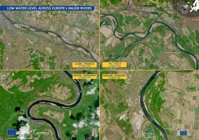
The great waterways of the Old Continent are facing a profound and visible transformationdriven by a combination of prolonged heat waves And structural water deficits. The images and analyzes processed by the European Earth observation programme Copernicus paint an extremely clear picture along the main river basins of Europe: from Reno al Danubepassing through the Loire until we get to ours Po riverthe hydrometric levels continue to contract significantly, allowing the surface to emerge extensive sand banks and dried banks where a steady flow of water once flowed.
The findings provided by satellites of the Sentinel fleet they allow the state of health of the continental water network to be monitored almost in real time. The footage from space shows with scientific precision how the impact on the territory is linked to a profound alteration in the distribution of precipitation: rains and snows are no longer spread evenly throughout the year, but tend to concentrate in individual extreme and violent episodesfollowed by long intervals of total absence of phenomena. This dynamic, combined with strong thermal anomalies and at summer temperatures stably above average, it prevents the soil from absorbing water effectively and is effectively redefining the contours of European river geography.
The connection with the peaks: the crisis of glaciers as “water towers” of rivers
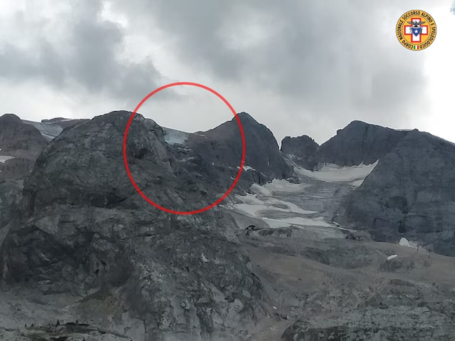
To fully understand the low levels of European rivers we need to go back to their primary source: i mountain glaciers and the snow at high altitudewhich represent the real ones “water towers” of large river basins. During the summer, the gradual melting of the ice and snow accumulated in the winter guarantees a constant supply of fresh water, supporting the minimum flows of the rivers even in the months without rain.
When the heat wave pushes it freezing point above 4500-5000 metresas has been happening more and more frequently in recent years, there is a dramatic acceleration of glacial melting. If in the immediate future this creates a temporary peak in flow, in the medium term it rapidly exhausts the snow reserve: the rivers thus find themselves deprived of their main water “lung” precisely at the moment of maximum summer heat and evaporation.
Comparison with the past: a crisis that becomes the norm
By comparing current satellite and hydrometric surveys with the historical data from the last decadesit emerges that extreme lean no longer represents a occasional or isolated event. If in the past the great historical shoals were cataloged as exceptional anomalies with multi-decade return timesin the last decade the frequency and the duration of these episodes have increased dramatically.
There are at the basis of this historical mutation physical and ecological mechanisms very precise. In addition to the distorted distribution of snowfall and rain, theevapotranspiration: increasingly higher air temperatures accelerate thedirect evaporation from waterways and soil, drying up the aquifers which should feed the rivers in the driest months. The end result is that the values of minimum flow ratewhich were once recorded only at the end of summer, are now reached weeks in advance, already between the end of June and the month of July.
Focus Italy: the Po river and the suffering of national basins
In Italy, the special observation inevitably remains the Po basinwhose river course strictly depends on the state of health of the glaciers of the western Alpine arc. The main Italian river is experiencing a prolonged contraction of its rangewith deficits between -70% and -80% compared to seasonal averages in the key sections of Cremona and Pontelagoscuro, pushing the Basin Authority to decree the “high” level of water severity for the entire Po Valley district.
Further dramatizing the situation in the Nordic area is the state of the large pre-Alpine natural reservoirs, which are also in drastic reduction:
– If Lake Garda (Benaco) manages to maintain around 50% of its capacity, the other main basins are now at the limit of zero.
– Lake Maggiore (Verbano) records a filling percentage that has dropped to 6.7%.
– Lake Como (Lario) stands at 5.9%.
– Lake Iseo is stuck at 5.7%.
There water crisishowever, is not limited to the Po Valley area alone. Studies conducted on the hydrological evolution of the last 80 years show how even historic watercourses in Central Italy, including the Tiber el’Arnoare undergoing a progressive and inexorable shrinkage of the riverbed and a structural decline in average annual flow rates. The combination between increasingly intense water withdrawals for agricultural and civil use, the concreting of the banks and a rainfall regime now characterized by long dry periods interrupted only by extreme rainfall, is radically altering the natural dynamics of our rivers.
The environmental and economic ramifications of the shoal
The drastic reduction in river flow transcends simple landscape data, triggering a chain reaction on multiple key sectors of society:
- Drinking use and emergency interventions: the lack of deep aquifers has forced over 100 municipalities between Piedmont and Lombardy to activate extraordinary supplies via tankers to guarantee water in domestic pipes.
- Rise of the salt wedge: when the flow of the Po falls below critical thresholds, the water from the Adriatic Sea rises up the riverbed for tens of kilometres. The salt intrusion sterilizes the Delta’s agricultural land and compromises drinking water supplies.
- Agriculture in pain: the decline in irrigation availability hits hard the symbolic crops of the Po Valley (in particular rice, stable meadows and fodder for livestock), causing huge economic losses.
- Energy and transport: on the energy front, the drop in levels limits the production of hydroelectric plants and makes it difficult to cool thermoelectric and industrial plants. At the same time, the navigability of European arteries such as the Rhine and the Danube is severely compromised, reducing the draft of commercial barges with serious repercussions on logistics.
- Biodiversity: the warming of residual waters and the contraction of aquatic habitats cause widespread fish deaths and the deterioration of wetlands, fundamental elements for ecological balance.
Future predictions and adaptation prospects
Climatology experts and water authorities agree on one key point: short-lived, high-intensity summer storms cannot solve a water crisis of this magnitude. Violent rains quickly flow to the surface, often causing damage and erosion, without managing to recharge the aquifers or restore mountain reserves.
In the medium and long term, the evolution of the framework will depend on two factors:
- The role of autumn-winter: the restoration of minimum levels in the riverbeds and basins will be subordinated to the arrival of extensive and persistent Atlantic disturbances during the autumn months, capable of bringing rain distributed over time in the plains and heavy snowfall in the Alps.
- Infrastructure adaptation: given that the river regime is evolving towards a marked “torrentialization” (long dry periods interrupted by short and violent flood peaks), it will be increasingly urgent to invest in rainwater storage basins, modernize the aqueduct network to reduce network losses and accelerate the adoption of precision irrigation techniques in the agricultural field.
