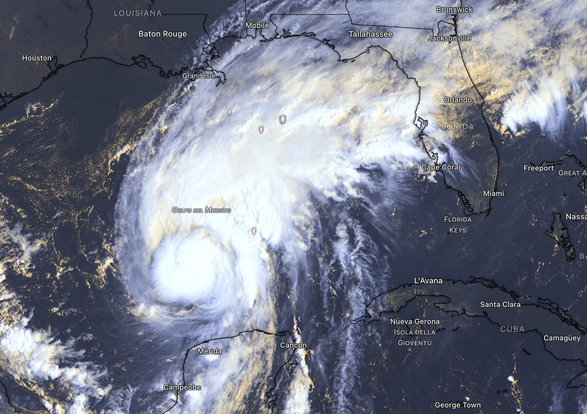
In the Gulf of Mexico it was born Hurricane Isaias, Category 1, and now it’s targeting the southern United States. It’s about the first hurricane of the 2026 Atlantic seasonwhich arrived with a strong delay compared to the climatological norm due to the probable inhibitory effect exerted by El Niño and the presence of dry air. Intense rain, storm surges and strong winds are expected in the risk areas in the next few hours. The alert is maximum in the area: several states have proclaimed a state of emergency, centers for the distribution of sandbags have been opened and several administrations have already ordered the closure of schools and recommended voluntary evacuations in the most exposed coastal areas, in particular between Alabama and Florida.
Why the Atlantic hurricane arrived late: the “double effect” of El Niño
To understand what could have caused this unusual scenariowith an Atlantic season that remained “asleep” for a long time while the Pacific recorded intense activity, the scientific community looks at the role of El Niño. This phenomenon involves a anomalous warming of the surface waters of the Pacific Ocean equatorial and tends to explain in probabilistic terms the opposite behavior between the two basins.
If in the Pacific El Niño would have acted as an accelerator due to the high surface temperatures of the water, in the Atlantic it would have produced the opposite effect through the so-called atmospheric teleconnections. The heat released in the Pacific in fact alters atmospheric circulation on a global scale, increasing the vertical wind shear over the Atlantic. This change in wind speed and direction at different altitudes in the atmosphere acts like a sort of “blade”, fraying storm clouds and preventing tropical systems from organizing themselves vertically.
To this probabilistic context would have been added the constant passage of huge masses of dry, dust-laden air coming from the Sahara desert which would have crossed the Atlantic throughout the summer, nipping convective motions in the bud. Only now, at the beginning of October, would the wind shear have temporarily weakened in the Gulf of Mexico, providing that favorable window that would have allowed the birth of the first Atlantic hurricane of the year.
Intensity, trajectory and the impact zone (landfall) of Isaias
The hurricane Isaiah it rapidly became structured over the waters of the southern Gulf of Mexico, reaching the status of Category 1 hurricane on the Saffir-Simpson scale. Aerial reconnaissance by NOAA’s “Hurricane Hunters” and radar data clearly outline its operational characteristics.
According to the latest bulletin from the National Hurricane Center, maximum sustained winds around the center of the cyclone reached 130 km/hwith the minimum central pressure falling to 975 hPa. The system is moving east-northeast at a speed of about 15 km/h, but a gradual change of course towards the north is expected which will lead it to directly target the southern coasts of the United States.
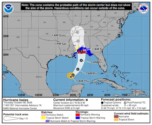
According to official projections from the National Hurricane Center, the landfall (the impact of the hurricane structure on the land) is expected between Friday evening and the day of Saturday 10 along the northern Gulf Coast of the USA. The area most at risk includes the stretch of coast between Mississippi, Alabama and northwestern Floridafor which an alert has already been issued.
The main risks associated with Isaias are not only represented by the winds, but above all by the torrential rains associated with the storm structure which could discharge up to 250 mm of rain within hours, triggering flash floods on coastal areas and inland.
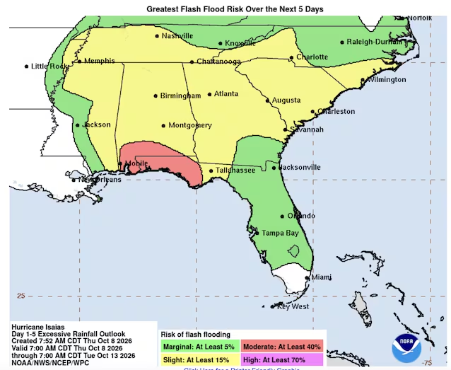
Furthermore, there is also apprehension regarding the rise in sea levels generated by the push of the cyclone, the so-called storm surgeof approximately 1.5-2.0 metres, which could cause coastal flooding.
