
After two weeks of intense hot along the entire peninsula, Italy finds itself again in the grip of bad weather: during the night a Milan they fell beyond 50 mm of rain and the alert was taken for Lambro riverclimbed by 1.70 meters according to the city councilor Marco Granelli on his social channels. Yesterday evening, August 19, in the province of Enna A person lost his life after his car ended up in Crisa stream due to a violent water bomb, while in most of the Liguria Theorange alert For the risk of strong thunderstorms, hailstorms and gusts of wind. Yellow alert also for Piedmont, Emilia-Romagna, Veneto, Tuscany and on some sectors of Friuli-Venezia Giulia and Marche.
So let’s see what the bulletin issued by the European Center foresees Estofex (European Storm Forecast Experiment) and what he has caused This new wave of bad weather.
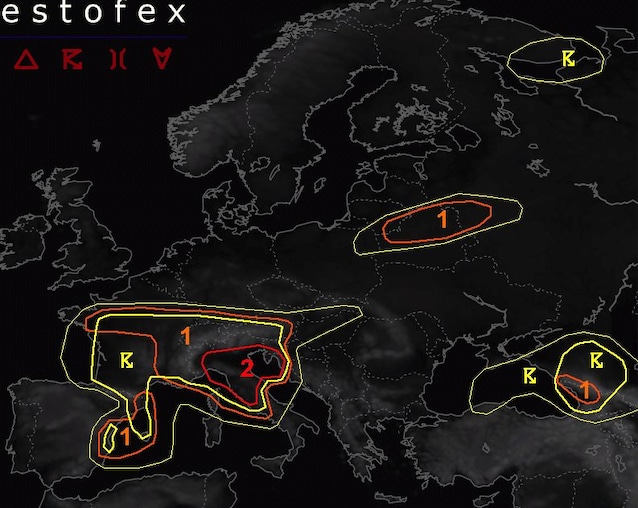
What does the bulletin issued by the Estofex Center on bad weather foresees
The European Storm Forecast Experiment (Estofex) has issued a bulletin of level 2 throughout the Northern Italy: means that phenomena such as haillarge or very large, intense rainsviolent gusts of wind and Tornado (to a lesser extent).
Specifically, the bulletin indicates 4 temporal series for the day of August 20: the first will affect the whole Northern Italy (In particular, Liguria, where abundant rains and hail is expected) mainly in the morning hours, and then move to Istria and Slovenia. The second wave of thunderstorms, on the other hand, will reach the Apennines within half day: In this case, supercelle will be able to reach the Adriatic coast, causing very large hail and strong gusts of wind. The supercelle, in fact, are storm cells capable of producing also Tornado, with quantities of rain over 100 liters per square meter.
The third temporal series, on the other hand, will be caused by some thunderstorms arriving from France or developed on the Alps: in this case, the risk of bad weather will be concentrated above all on Piedmont and on the most eastern regions during today’s evening.
The fourth and final phase will lead to the development of some thunderstorms in Liguria, which then towards the east and north-east, reaching north-eastern Italy, south-western Slovenia and north-western Croatia in the early hours of tomorrow 21 August. Also in this case, the rainfall will be intense, with violent winds with the risk of Downburst (currents that go violently from a temporal cloud and that spread rapidly in every direction once they impact the ground).
What is causing bad weather in Italy
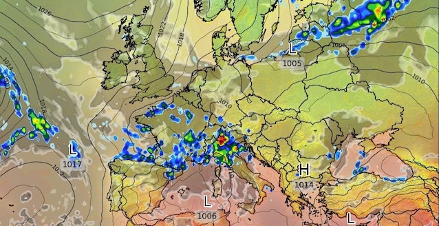
But what is this new wave of bad weather cause? According to what is also reported by the Civil Protection, the case is to be attributed to one disturbance of Atlantic origin Coming from France, which will bring meteorological instability on most of the northern and central Italian regions.
In essence, bad weather is linked to the arrival of a bag of cold air Originated in the Atlantic, which has undermined the African anticyclone responsible for the high temperatures of the last week. Just the clash between the cold air coming from the Ocean El ‘African hot air He caused the violent thunderstorms and rains that hit the country.
Among other things, rains and thunderstorms of the past few hours have proved particularly violent also due to the heat of the last few days: the hot air, in fact, more easily retains the water vaporwhich will tend to condense when the air temperature is off. By condensing quickly, the water vapor will form clouds that will download all the humidity andthermal energy accumulated.
In the bulletin emitted by the Estofex Center, then, hail of “large size” is expected: the hail beans, in fact, can become larger when the ascending currents (present inside the cumulonembi) are so strong that they report High altitude hail beans. At that point, a new layer of water will join the surface of the grain freezing at high altitude and further increases the size of the hail.