
Off Sicily, 40 km away from Portopalo di Capo Passerothe engineer André Chaisson analyzing the batimetry of the seabed of the Mediterranean has identified a structure submerged to approx 250 m depth with a geometry reminiscent of the plant of a very large cityabout 17 km long and about 4 km wide. The author of the discovery, which took place in 2024 during his research on the lost city of Atlantis, hypothesized that it may be Telepylosthe city of the Lestrigoni appointed in the Odyssey. According to Chaisson, up to about 10,000 years ago It was located on a coastal territory that emerged, and then gradually disappear due to theSea level raising with the end of the last glaciation. The hypothesis of the existence of this submerged city presents weak points of a geological and historical nature And it is based only on the analysis of the batter data, without an exploration of the seabed has ever been accomplished.
The hypothesis of the submerged city of Telepylos off the coast of Sicily
The submerged structure identified by André Chaisson on the maps obtained from the mouth -spid data would be found between Sicily and Maltaa 250 m depth. 17.64 km long and 4.41 km wide, on the maps it appears surrounded by a 50 km long channel and about 500 m wide and characterized by a structure similar to a port. If its measures are converted into stadiums (unit of measurement used in ancient Greece, equal to about 176 m) there is a dimension of 100 x 25 stadiumswhich could suggest careful urban planning.
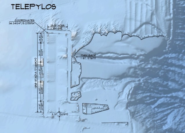
According to Chaisson, its characteristics and its geographical position could correspond to those of Telepyloscity mentioned in the Odyssey where the Lestrigoni lived, anthropophagous giants who destroyed Ulysses’ fleets. Ulysses’ trips are set Between the thirteenth and twelfth century BC During the Mycenaean period, but the author believes that the city was much older and that at that time it had already disappeared. According to Chaisson, Telepylos was built on a territory that had emerged during the last glaciation (which began 110,000 years ago and ended 11,700 years ago). In fact, in that period of time, with the decrease of temperatures, large quantities of water were trapped in the solid state in the glaciers and the sea level had dropped considerably causing many territories before submerged. With the end of the glaciation, the melting of the ice and the consequent raising of the sea level, Telepylos would have been progressively submerged until they disappear around 8600 BC
Because the existence of the submerged city is not very credible
The studies carried out to date on variation of the global level of the sea During the last glaciation and in the hottest interglacial period that followed its end they tell us that this has never exceeded 130 m. The alleged by Chaisson Telepylos is instead located 250 m deep: this means that the variation of the Mediterranean Sea level should have been much more accentuated than the documented one. Chaisson argues that no sufficient data have been collected in the Mediterranean basin, so according to him the latter hypothesis could be plausible.

The engineer believes that the Batimetric data suggest that 20,000 years ago, during the last glaciation, in correspondence with the Strait of Gibraltar there was a Bridge of Earth that emerged which connected southern Spain with northern Morocco. In this way the Mediterranean it would become a pelvis isolated from the Atlantic Oceanin which the intense evaporation would have made the sea level drop rather than in the rest of the planet. From the studies done so far, however, it appears that in this interval the Mediterranean and the Atlantic remained connected (their separation dates back to 5.5 million years agowhen the lifting of the area of the Strait of Gibraltar isolò the Mediterranean for 700,000 years). The submerged Telepylos hypothesis appears not very credible also because 10,000 years ago in the Mediterranean there were no evolved civilizations. On the seabed, however, testimonies of Mesolithic populations of hunters-racketors who lived islands then emerged in Sicily channel.
Why then do we see a regular structure on the Mediterranean backdrop in the maps? It could only be an image generated by the elaboration of the batter data and therefore not real. To dispel any doubt, direct exploration of the seabed would be necessary, which has not been done so far.
