After the Italian theme, the course has officially begun second written test of theMaturity exam 2026the one dedicated to matters of direction: at the scientific high school, high school graduates are facing the mathematics test which this year includes problems linked to episodes that actually happened, from the earthquake in Friuli in 1976 to the water level of the Lake Braccianolocated in Lazio, near Rome.
In fact, students are asked to reconstruct the mathematical model it describes the trend of the water level of Lake Bracciano over time, starting from the 2016-2017 withdrawals and their subsequent suspension. Behind this trace, however, there is a real and complex water crisis to manage, caused by climate change and the human exploitation of this basin, whose waters in 2017 had dropped to -180 cm compared to “hydrometric zero”.
At the moment, the water level of Bracciano is slowly rising: according to the Observatory of the Central Apennines District Basin Authority (AUBAC), the lake remains in a situation of fragile balance.
The characteristics of Lake Bracciano: how it was formed
To understand why Lake Bracciano is so fragile, we must first analyze how it was formed. About 600,000 years agothat area was characterized by intense activity in the Volcanic District of the Sabatini Mountains (north of Rome): there was not a single large volcano, but many scattered eruptive centers (such as those of Sacrofano, Baccano, Trevignano, Vigna di Valle, Bracciano, Martignano, Polline, Lagusiello and Monterosi). Among these, the most important was that of Sacrofano, which produced enormous quantities of pyroclastic material.
As reported in the report carried out by ISPRA, the progressive emptying of the large magma chamber that fueled the activity of the numerous eruptive centers of the Sabatino volcanic complex (together with the activity of a system of regional faults), caused the collapse of the top part of the structure, which occurred approximately 300,000 years ago, with the formation of a large volcano-tectonic depression that gradually it filled with water giving rise to Lake Bracciano.
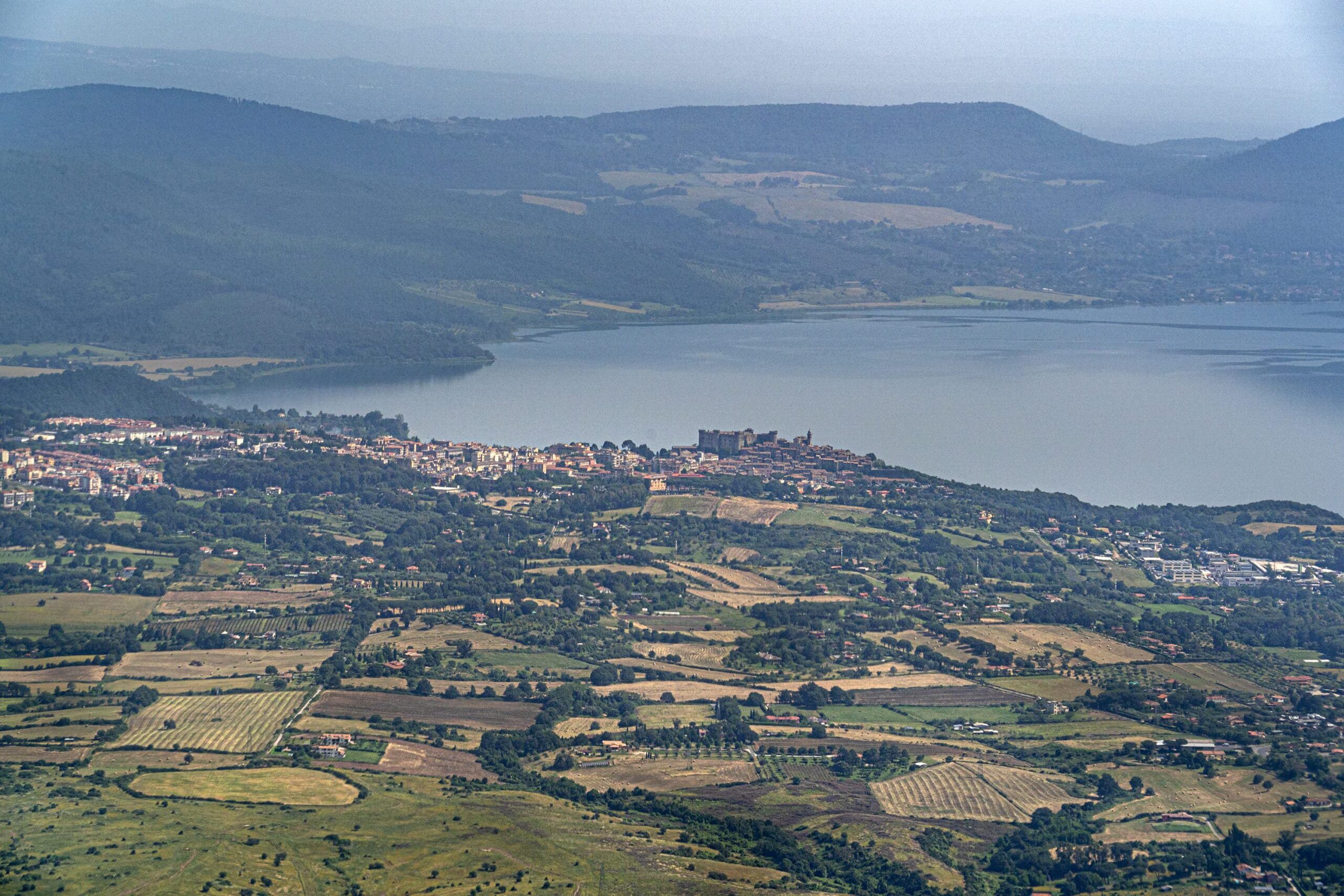
The result, therefore, is a lake extremely deep (between 160 hey 165 meters), with a surface area of approximately 57 km² and an estimated volume of water in 5 billion cubic meters: already exploited since ancient times, in the twentieth century the lake, suitable for bathing, became to all intents and purposes a strategic water reserve for the Capital.
Being a lake of volcanic origin, that of Bracciano it has no large rivers feeding it. The water almost all comes from large underground springs and from the rain that falls directly on the surface (or on the surrounding basin), while the Arrone river it is the only natural emissary.
In practice, therefore, Lake Bracciano is an “almost closed” system that slowly recharges through groundwater and rain: when these inputs are reduced (due to drought or overexploitation) the lake has no way of compensating for losses in speed. The lake, among other things, constitutes an area of high naturalistic value and biodiversity, being the habitat of endemic species.
In short, Lake Bracciano is simultaneously one strategic water reserve for Rome and a ecosystem of primary interest.
The 2017 water crisis and its causes
For decades the Bracciano level has remained essentially in good health. Then, in 2017, things got worse. The CNR Water Research Institute (IRSA-CNR) has been monitoring the lake for over 15 years, collecting data both on amount both on the quality of water. Data from that summer showed that the shoreline had receded significantly, revealing rocks and sand, and by July 2017 the level had dropped to -163 cm compared to the “hydrometric zero” (the reference altitude of the lake).
In the following weeks, in reality, the situation worsened further: at the end of July it reached around -167 cm and during the summer the minimum reached even lower values, with some findings reporting up to -180 cm.
These levels represented a significant problem: the IRSA-CNR researchers had in fact reconstructed a digital model of the “basin” of the lake and calculated that the maximum sustainable excursion from the system was of -150 cm. Beyond that threshold, a significant reduction in the areas involved in natural self-purification processes was observed in the lake.
Lake Bracciano, in fact, functions as a sort of gigantic filter ecosystem: at -150 cm loses Already 13.4% of the seabed surface dedicated to these purification processes and the worst case scenarios indicated that, going down to -200cm, the loss would have reached the 22.5%.
These drops, which were also damaging the water table around the lake, were caused by a combination of factors: the climate change and the overexploitation of the lake.
A group of researchers, in a study published in 2021 in the journal Journal of Hydrology: Regional Studiesanalyzed the data over the span of a century, demonstrating that, starting from late 90s, there variation monthly lake level is doubled compared to previous decades. And, in parallel, it is doubled also the variation of withdrawals monthly by Acea, while the precipitation annuals have become more irregular and the average temperature rose.
In practice, the lake found itself simultaneously subjected to a more extreme climate and more intense exploitation.
A 2023 scientific review, published in the scientific journal Waterframed Lake Bracciano as an example of a ecosystem of value put at risk by growing human pressures. Over the last twenty years, various environmental problems (in addition to human exploitation) have significantly reduced its ability to provide “ecosystem services”, i.e. everything the lake provides: drinking water, fishing, recreational opportunities.
The current situation
After the 2017 measurements, i withdrawals they were gradually discontinued: at that point, the water level of the lake started to rise again, but a lot slowly. According to data reported in a 2026 study also published in the magazine WaterIn the 2018 the level had only risen slightly 40cm compared to the historic low of 2017, while in April 2023 the overall recovery was 98cm. In the meantime, the Arrone river (as known as the historical emissary of the lake) remained disconnected, because the water level remained below the overflow threshold.
But what is the current situation? The most recent updates report a lake in precarious balance, but in slight recovery. According to the bulletin of the Observatory of the Central Apennines District Basin Authority (AUBAC), relating to November-December 2025, after the strong reductions in levels typical of summer, in the months of November and December it was observed an arrest of the descent for all the main natural lakes in the district.
In the specific case of Lake Bracciano, the level And ascended come on 161.69 m above sea level October 2025 to the 161.8 m registered in the first days of 2026. It is a value comparable to that of the same period in 2023 and higher than that of December 2024: small signs of recovery, driven above all by the intense rains of late 2025 and early 2026.
The same bulletin, however, reports that 2025 was overall a year below the climatological average: in Lazio the rainfall in November and December differed from the average by -36% and -17% and at district level the groundwater recharge in 2025 was lower than historical valueswith deviations exceeding -30% in most regions.
For a lake that depends precisely on rainfall and groundwater, this is no small detail: this is why the Observatory has classified the water severity of ATO 2 (which covers the area of Rome and Lake Bracciano), as “average”, in a framework defined as fragile balance.
The most recent data, relating to May 2026, show a stable lake level around 162.39 m above sea level.