
With the recent drop in temperatures, even in Italy we have started talking about “polar vortex” and its weakening as possible cause of the harsh winter that awaits us. But what does all this mean? The polar vortex is a sort of permanent cyclone over the Earth’s polespowered by very low temperatures. When this vortex is compact it retains the cold aloft, but if it weakens it can become discontinuous and, therefore, more sensitive to disturbances coming from the troposphere.
According to what meteorologists have found, the polar vortex is currently “at an all-time low” and has recorded exceptionally low values of wind at 10 hPa – the lowest level ever observed in the last 45 years – due to a quick stratospheric warming. Let’s understand why a weaker polar vortex could cause a harsher winter in Europe.
What is weakening the polar vortex and the possible consequences
To simplify, we can say that the polar vortex is a sort of ring of very strong winds that rotates around the Earth’s poles, fueled by very low temperatures. The polar vortex is divided into two components: one at high altitude (in the stratosphere) with high-speed currents of an almost circular shape, and a lower component (in the troposphere) at lower latitude: this component is called jet stream (or jet stream).
The role of these jet streams is to “confin” the very cold polar air, preventing it from reaching lower latitudes. As anticipated, this vortex is weakening, due to a rapid warming of the stratosphere (Sudden Stratospheric WarmingSSW) which is affecting the lower layers, already bringing cold and snow to some areas of the United States and Canada.
In fact, in the event of warming at high altitudes, the polar vortex can weaken or even “break”, becoming discontinuous. Consequently, this weakening can favor the descent of cold and unstable air towards our latitudes.
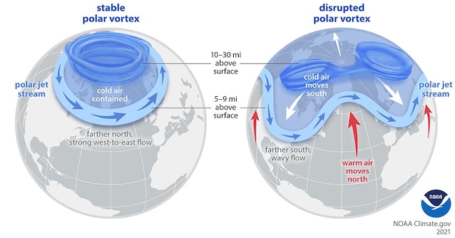
As also visible in the image above, a strong polar vortex (and therefore stable) implies a strong polar circulation, which block the coldest air in the polar regions and prevents it from escaping. In contrast, a weak polar vortex has much more difficulty containing cold air. To explain it simply it is as if, due to the SSW, a “gap” opened in the barrier which confines the cold polar air. At that point, this cold air from the Arctic can descend and reach lower latitudes, increasing the chances of cold waves on Italy and, more generally, on the entire Mediterranean.
The forecast for the next few days: will there be snow?
But, therefore, it is certain that the next one European winter will be particularly rigid? According to meteorologists, a weak polar vortex does not automatically mean a freezing winter season is on the way. In many cases, these disturbances of the polar vortex remain confined to high altitude and do not modify the circulation over Europe. A less compact polar vortex, however, can weaken more easily: we will therefore have to wait any changes for greater certainty.
From a forecast point of view, the weather in Italy will be mostly stable: al North, in fact, sunny and stable weather is expected in almost all sectors until the weekend, with maximum temperatures around 10 °C.
Al Center it will be mostly sunny or partly cloudy until Sunday in Tuscany, Lazio and Umbria (maximum temperatures between 8 and 11 °C), with the exception of the more internal Apennine areas, where snow is expected from 900 meters. Al South, instead, today instability is expected in Calabria, Puglia, Basilicata and Sicily with intermittent rain and showers (maximum temperatures up to 14 °C), while between Friday and Sunday it will be mostly sunny and maximum temperatures between 14 and 17 °C.