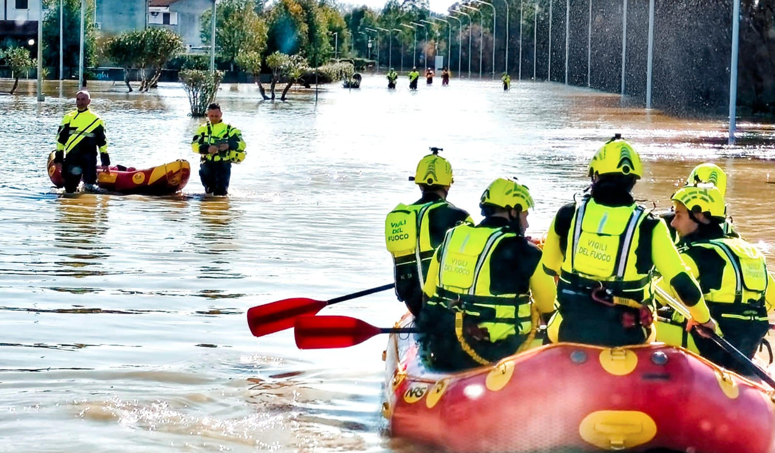
There province of Cosenzain north-eastern Calabria, was hit by very heavy rainfallwhich in recent days have reached 270 mm of rain cumulative in 48 hours. This brought the Crati river to break its banks in several places in the Sibari Plainand then comes out and floods the surrounding area with its waters. Among the municipalities most involved are those of Corigliano-Rossano and of Cassano allo Ionio.
Although there were no victims, the flood caused serious consequences: hundreds of people were evacuated hey damage to buildings, infrastructure and agricultural land have been hugeto the point that Calabria requested it national state of emergency and it state of calamity in agriculture. The event occurred in an ad territory high hydrogeological riskwhose fragility must also deal with the increasingly frequent occurrence of intense rainfall due to climate change.
The flooding of the Crati river in the Sibari plain: the enormous damage
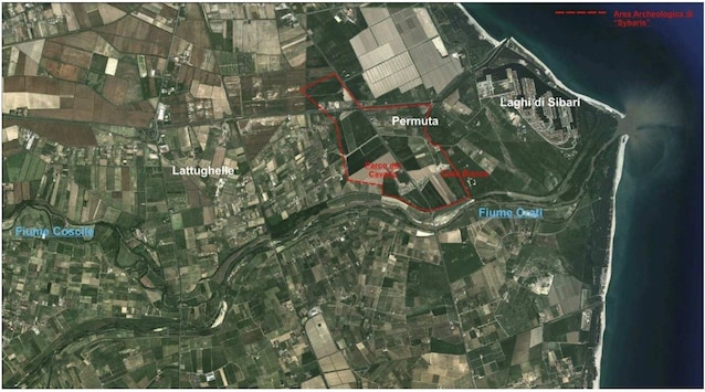
The meteorological event that hit Calabria in recent days had serious consequences also because in the previous weeks the rainfall had already made the soil saturated with water. When this occurs, water flows to the surface rather than infiltrating the ground and the hydrogeological risk increases. The most serious situation concerned the river Crates: the intense rainfall that fell in the part of its catchment area upstream from the Sibari Plain caused it to flood near the mouth. Its waters thus broke the earth banks in several places flooding vast territories on both banks. The locations most affected were Corigliano-Rossano, Cassano allo Ionio (in particular the Sibari Lakes, the Sibari Archaeological Park and the Lattughelle district) and the plain of Inlay. They register here enormous damage to agricultural landwhich have compromised crops, as well as homes and infrastructure. In the Cosentino area the meteorological event also caused the Busento and Campagnano rivers to flood. Landslides and flooding have also affected other provinces of Calabria, with extensive damage to agriculture. Currently, the teams of the Calabria Reclamation Consortium are at work with monitoring and cleaning activities in the most affected areas.
Calabria, a territory at high hydrogeological risk: the consequences
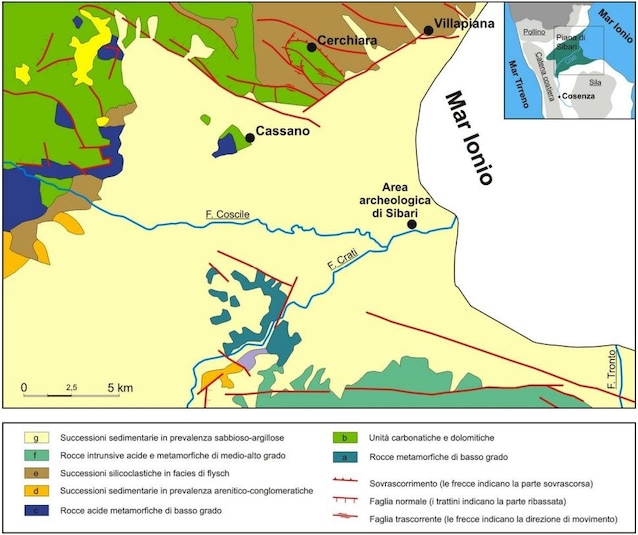
Calabria, due to its geographical conformation and its geological characteristics, is particularly vulnerable from the point of view of hydrogeological instability. The predominantly mountainous territory means that the waterways follow a short path with significant gradients, often originating sudden floods because little time passes between the rainfall upstream and the flood downstream. Furthermore, mountain slopes are often made up of waterproof rocks like clays, which facilitate the flow of water on the surface and whose fragility predisposes the territory to landslide phenomena. To aggravate the instability in the area affected by the event there is a complex tectonicswith a system of active faults that dictates the geometry of the Crati Valley and the Sibari Plain, and which contributes to a high degree of rock fracturing. Other factors that make the region ad the hydrogeological risk is high they are illegal construction, the abandonment of mountain lands and the lack of maintenance of slopes and waterways.
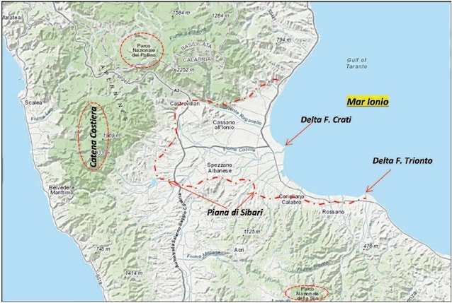
The particular morphology of the Sibari Plain
There Sibari Plainthe largest plain in Calabria which suffered the most serious consequences of the event, has already been affected in the past by numerous flood events. It is crossed by the Crati river, which crosses it before flowing into the Ionian Sea with a delta, by its main tributary Coscile and by smaller waterways. The plain is surrounded by three imposing mountain massifs: the Silano plateau to the south, the Pollino range to the north and the Coastal range to the west. From a geological point of view, it constitutes the northern portion of the Crati graben, an extensive depression of tectonic origin delimited by faults, located in the connection area between the terminal part of the southern Apennine chain to the north and the Calabro Peloritano Arc to the south. Over time the depression was filled by alluvial sediments deposited by the Crati, which then consolidated causing the progressive lowering of the level of the plain. In some areas in recent decades the soil has subsided further due to withdrawals from aquifers. The Sibari Plain was a marshy area, reclaimed and made cultivable in the 1930s, and the fact that it is morphologically depressed favors flooding in the event of flooding.
The flooding of the Sibari Plain once again highlights the importance of prevention. The monitoring of watercourses and landslide phenomena, and the maintenance of the works created to defend against landslides and floods are fundamental. Furthermore, one is essential correct territorial planningwhich involves the constant updating of hydrogeological risk maps.