
While the Niscemi landslide continues, with new landslides recorded over the previous nights, media attention remains high on hydrogeological risks of our territory: according to the latest report from ISPRA (Higher Institute for Environmental Protection and Research), 94.5% of Italian municipalities are exposed to risk for landslides, floods, avalanches and/or coastal erosion.
Overall, approx 8 million inhabitants reside in territories considered vulnerable from a hydrogeological point of view: in the space of just 3 years, the surface there is a landslide risk increased of 15% (a fact that should be read by also looking at the best mapping capabilities), with 742,000 buildings And 75,000 businesses now exposed to landslides or floods. Let us therefore see in detail the results of the Report on hydrogeological instability in Italy.
The map of hydrogeological risk in Italy
Today in Italy, approximately 8 million inhabitants (The 13.6% of the population total) live in vulnerable territories from a hydrogeological point of view. Of these, further 6.8 million people they live in areas a flood risk with medium hydraulic danger, while 1.28 million live in areas with high or very high landslide danger.
To all this must then be added 742,000 buildings And 75,000 businesses exposed to high risk, in addition to the 14,000 cultural assets located in areas with high or very high danger from landslides.
As the map below also highlights, the danger for landslides and floods is divided into different levels: in the case of landslide events, we start from areas of Attention (AA), and then rises to landslide danger moderate (P1), average (P2), high (P3) e very high (P4). To get an idea, the town of Niscemi it is located in a hazardous area P4, the maximum.
If instead we look at the risk floodsthe danger is divided into low, medium and high.
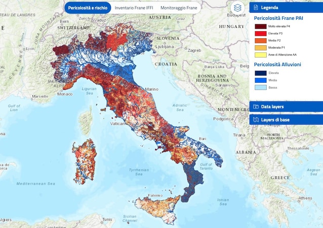
To understand in which danger range the area where we live falls, ISPRA makes its national platform available IdroGEOthanks to which users can search for an e identify the level of danger for landslides and floods within a radius of 500 meters from the point of interest, be it a home or the headquarters of an economic activity.
What the ISPRA report reveals on hydrogeological instability
According to the ISPRA “Report on hydrogeological instability in Italy”, the 94.5% of municipalities Italians (i.e. 7,463 local administrations out of a total of 7,896) fall in areas with risk For landslides, floods, coastal erosion or avalanches. The disaster that occurred in Niscemi, Sicily, therefore does not represent an isolated phenomenon, but the problem involves almost the entire peninsula.
One of the most relevant data that emerges from the report is the expansion of areas classified a landslide danger. Compared to the 2021 findings (the ISPRA report is in fact published every three years), the national surface considered dangerous for landslides is increased of almost the 15%. If we also consider the “areas of attention”, today approximately 69,500 km2 — equal to 23% of the entire national territory — are potentially subject to landslides. It must be said, however, that this increase is not only due to new landslides, but above all to a improvement of the ability to mapping by the authorities, who updated the Hydrogeological Management Plans (PAI).
Going into specifics, the regions with the greatest number of inhabitants at risk landslide I’m there Campaniathe Tuscanythe Liguria el’Emilia-Romagnawith the most significant increases in danger (classified as P3 and P4) recorded in the Autonomous Province of Bolzano (+61.2%), in Tuscany (+52.8%), in Sardinia (+29.4%) and more Sicily (+20.2%).
In practice, this means that landslide hazard areas high (P3) e very high (P4) now represent the 9.5% of the national territory.
Italy is thus confirmed among the European countries most exposed to these risks, with more 636,000 landslides recorded in the Inventory of Landslide Phenomena in Italy (IFFI), created by ISPRA together with Regions, autonomous Provinces and ARPA. Of these, the 28% they are extremely rapid phenomena with high destructiveness, which unfortunately often leads to serious consequences in terms of loss of human lives.
Looking instead at risk floodsthe ones that stand out again are theEmilia-Romagnathe TuscanyThe Veneto and the Lombardy.
But, therefore, from the point of view of risk mitigation, what is being done? According to the balance of interventions monitored by the platform ReNDiS, in the last 25 years in Italy they have almost been financed 26,000 projects for the safety of the territory, for a total of over 19.2 billion euros.