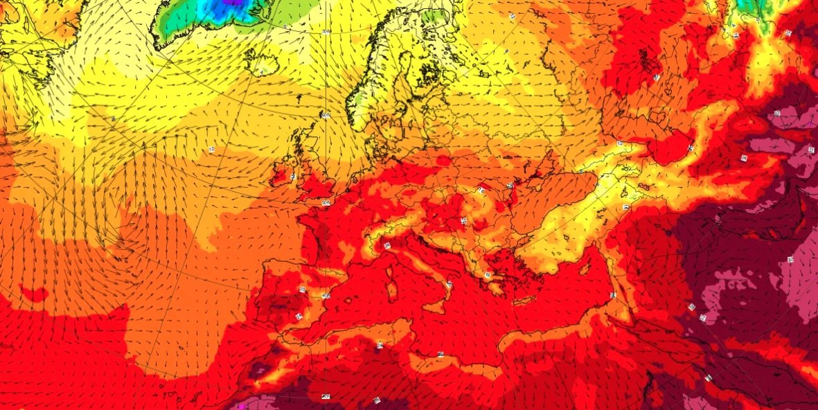
On theItalyand on theWestern Europethe first real one has arrived heat wave this year, which is causing very high temperatures and definitely above the seasonal average for the end of May. The responsibility for this heat can be attributed to a anticyclone of subtropical North African origini.e. an area of high pressure rising from North Africa towards our continent. Labeling it as an “African anticyclone”, however, is a simplification: according to forecast models, much of the warm air originally arrived from the Atlantic, with the subsequent involvement of air masses that passed between North Africa and the western Mediterranean.
The peak heat will be reached in Wednesday 27th and Thursday 28th Maywith temperatures up to 36/37 °C in Northern Italy: as also reported on the Ministry of Health website, the red sticker was issued for 28 May in cities such as Bologna, Florence, Turin and Rome.
Where does the mass of hot air that reached Europe and Italy come from?
In recent days the same word has been heard repeated everywhere: African anticyclone (i.e. a rotating area of high atmospheric pressure and with a closed structure). In fact, it would be better to talk about an anticyclone North African subtropical matrix: as reported by the 3bmeteo experts, the anticyclonic promontory that is affecting Europe these days is actually came up from North Africa towards our continent, but this it doesn’t mean automatically that all the air mass involved comes from straight from the Sahara.
According to the data provided by some forecast models, in fact, a good part of the warm air initially arrived from the Atlantic towards Europe, to then be followed by a greater involvement of air passing between North Africa and the western Mediterranean.
The distinction is not just academic: the continental African air mass is typically dry and already very hotwhile a subtropical air mass of Atlantic origin is generally wetter and less extreme initially, but can still warm enormously along the way.
Today, among other things, the Mediterranean climate is warmer than in the past: consequently, even structures not characterized by a pure Saharan air mass can lead to temperatures above the seasonal average.
Heat waves, in fact, have always existed, but today they develop in an atmosphere that is on average warmer. This means that the same meteorological configurations (same type of anticyclone, same heat dome, etc.) could produce higher temperatures than some would have done decade ago.
When will this heat end: the forecast for the next few days
The question that many are now asking, however, is only one: when will this heat end? Anticyclonic promontories of this type tend to persist for several days, precisely because their structure “block” the entrance of fresh air and disturbances. Trying to simplify, therefore, as long as the anticyclonic “wall” holds, the cooler currents will not be able to break it.
Wednesday it will be the day of peak due to the heat in the North-West: between Lombardy and Emilia-Romagna the temperature will reach 36 °C, with local peaks of up to 37 °C in cities such as Milan and Lodi. The heat will also persist in the Center and on the major islands (with Sardinia in particular it could approach 34°C), while in the South temperatures will only undergo slight drops before increasing again over the weekend. The freezing point will remain around 4000 metres, with a slight decline in the eastern Alps where the first signs of instability will begin to appear.
Starting Friday, instead, the anticyclone will begin to weakenpaving the way for north-eastern currents, which could trigger the first thunderstorms in the central-eastern Alps in the afternoon. In the evening and night the instability will extend to the central-eastern Po Valley, then reaching lower Piedmont, Liguria and a part of Tuscany.
According to projections, the heat will however persist until the end of the month. In fact, between the last Sunday of May and the beginning of June, high pressure should still remain over the Mediterranean and the southern regions.
In any case, what makes this episode particularly significant is not just its intensity, but its precocity: we are only at the end of May and in different areas of Europe they could touch or exceed the monthly temperature records.
In France for these days maximum peaks are expected around 37/38 °Cwhile in Spain the peaks will reach up to 40/42 °C; in United Kingdom, Netherlands and Germany they are expected 32/33 °C. The French meteorological service has already warned that temperatures could reach unprecedented values for the season, while the Spanish weather service AEMET has confirmed that the peak temperatures are expected between Wednesday and Friday, with generalized highs of 36-38 °C.
The first heat waves between May and June, among other things, tend to have the most impact on both ecosystems and people, who have not yet had time to adapt to the summer heat.
