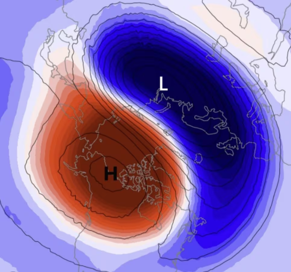
In recent days we have returned to talking insistently about Polar vortex, coming next week, and its possible interactions with El Niño. As happens promptly at the beginning of autumn, as we approach the equinox, the internet and social media have been filled with alarmist headlines predicting extreme scenarios and phenomena for the cold months, oscillating between “the coldest winter of the century” and “endless anomalous heat”. To clarify and avoid sensationalism, we need to understand the physics of these phenomena: what the polar vortex really is, how its complex “thermal machine” works and in what way El Niño in the Pacific Ocean may (or may not) affect our climate.
What is the polar vortex and how it works (without alarmism)
The Polar vortex it is not a passing storm nor an exceptional event, but one cyclical and permanent structure of the planetary atmospheric circulation that forms every year between autumn and spring over the polar regions. From a physical point of view, it is a large area of low pressure around which very high speed westerly winds rotate.
There are actually two overlapping “vortices”:
- the tropospheric polar vortex: located in the lowest part of the atmosphere (up to about 10 km above sea level), in direct contact with the earth’s surface and with daily meteorological phenomena;
- the stratospheric polar vortex: located higher up (between 15 and 50 km above sea level), a real “top” of freezing air which is activated in autumn due to the radiative cooling linked to the polar night.
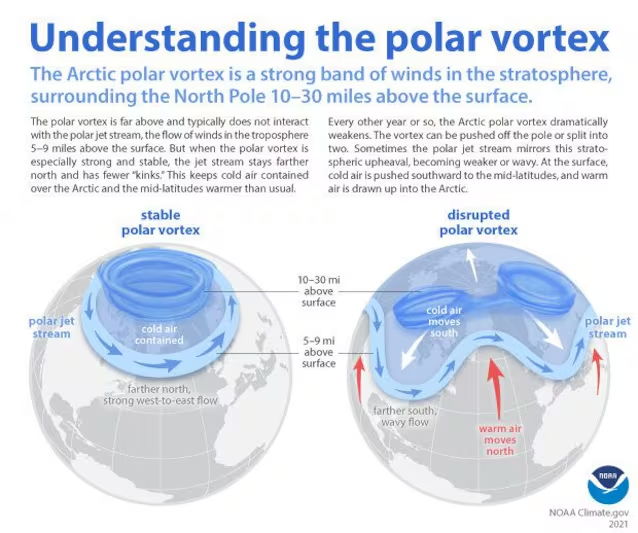
The health and stability of the Polar Vortex determines the behavior of air masses at mid-latitudes:
- the strong and compact polar vortex: the westerly winds (the so-called Jet Stream or Jet Stream) blow intensely at high altitude, keeping the frost confined within the Arctic Circle. In this scenario, generally milder conditions prevail over Europe and Italy, with the transit of normal Atlantic disturbances or the presence of high pressure;
- the weak or disturbed polar vortex: as the vortex loses strength, its winds slow and the jet stream begins to “wavy” noticeably. This structure allows the Arctic ice to descend towards the south and the warm equatorial air to rise towards the north, increasing the probability of cold waves and snowfall at low altitudes in our latitudes.
The interaction with El Niño: the physics of teleconnections
One of the most debated topics concerns the influence of El Niño, the anomalous warming of the surface waters of the equatorial Pacific Ocean, on the stability of the Polar Vortex. Since these are two phenomena separated by thousands of kilometers, their interaction does not occur directly, but through the atmospheric teleconnections.
In their interaction, the ocean surface and the stratosphere cause:
- energy release: during El Niño phases (particularly in intense events), the Pacific Ocean releases enormous amounts of heat and humidity to the equatorial atmosphere;
- generation of planetary waves: this surplus of energy alters the tropical circulation and triggers massive standing atmospheric waves which propagate upwards and towards high latitudes;
- polar vortex disturbance: having reached the stratosphere, these waves can “impact” the structure of the polar vortex, transferring heat to it and slowing down its rotation.
From a statistical point of view, years characterized by a strong El Niño show a increased frequency of Sudden Stratospheric Warming (SSW) eventsi.e. sudden warming of the polar stratosphere (even 30-50°C in just a few days). When an SSW occurs, the stratospheric Polar Vortex can break up (split) or be displaced from its natural location (displacement).
What does all this mean for winter in Italy?
A common mistake in the media is to consider the equation “El Niño = Weak polar vortex = Cold winter in Italy” as a mathematical certainty. Climatology works by probability, not by automatism.
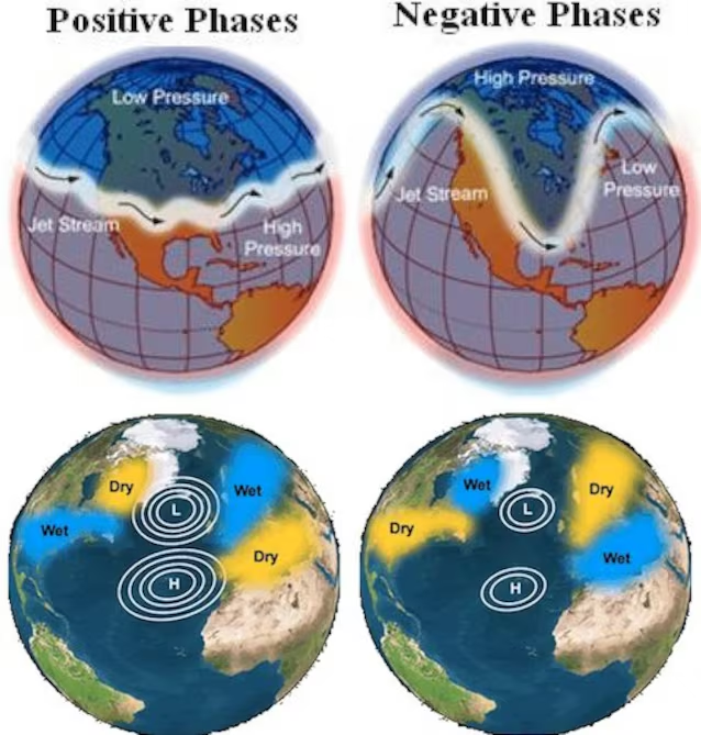
The impact of a possible weakening of the polar vortex on Europe and the Mediterranean basin depends on multiple regional variables. On the one hand the pVortex breaking grease: a breaking Polar Vortex does not guarantee that the frost will end up in Italy. The “flows” of cold air can head towards North America, Siberia or the Atlantic, leaving the Mediterranean under the influence of temperate currents. On the other fLocal Atlantic actors: the index NAO (North Atlantic Oscillation), i.e. the climate indicator (negative or positive) that measures the difference in atmospheric pressure between the high pressure of the Azores and the low pressure of Iceland, plays a fundamental role in deviating the trajectories of the pressure minimums.
The probabilistic trend for the cold season
Based on long-term seasonal models (such as data provided by ECMWF and NOAA), the trend for Italy is ideally divided into two moments:
- First part of winter (late autumn/December): prevalence of an atypical Atlantic circulation with frequent rainy passages. Temperatures remain in line with or slightly above climatological averages, with little risk of prolonged frost.
- Second part of winter (January/February): increased probability of stratospheric disturbances affecting the Polar Vortex. This phase presents a risk statistically higher than temperature changes and of potential episodes of cold and snow at low altitudes, if the undulations point directly towards the Mediterranean.
The Polar Vortex and El Niño are pieces of an extremely complex global climate puzzle. El Niño does not “command” the daily weather in Italybut shifts the axis of seasonal probabilities. Following the formation of the Polar Vortex in the coming months will allow us to evaluate the stability of the atmospheric circulation, always remembering that the weather forecasts stop at 5-7 dayswhile seasonal projections only indicate the trend of air masses on a continental scale.
