Typhoon Champi heads towards Taiwan, with winds over 240 km/h and 13 meter waves. According to forecasts, it will not directly touch land, but maximum alert remains for storm surges, heavy rains and landslides. Over 100 flights cancelled: its route will continue towards China and Japan.
The Western Pacific is once again the scene of a serious meteorological emergency. The typhoon Champi (currently category 3)one of the most severe storms recorded in this area this year, is moving towards Taiwanmaintaining a destructive power that prompted the Taipei government to proclaim maximum alert is of land That sea.
THE’eye of the storm it is currently located at approx 500 km south-east of the island and advances threateningly towards the north-eastern coast at about 15 km/h of speed, and then continues its route towards northern China and southern Japan where it is expected to lose energy. Barometric analyzes indicate one minimum central pressure of 946 hPaa direct indication of a deep and highly structured tropical cyclone.
The details of Typhoon Champi: sustained winds and storm surges
Wind intensity data measured at the center of the system confirm the potential danger of the event. Champi is currently recording sustained winds of 105 knots (about 195 km/h) with gusts reaching 130 knots (over 240 km/h).
The latest findings and modeling simulations report significant waves with maximum heights of up to 13 metres in the open sea. This colossal wave motion is pushing massive storm surges towards the eastern and southern coasts of Taiwan, directly threatening ports and coastal infrastructure along the Hengchun Peninsula. There is also concern about the phenomenon of “storm surge“, i.e. an anomalous and sudden rise in sea level generated by the combined action of stormy winds and low atmospheric pressure, capable of inundating the coastal and flat areas adjacent to the coast.
Timing of passage: when it will come closest to Taiwan and where it will go
Analysis of the forecast map drawn by the Joint Typhoon Warning Center (JTWC) shows that the typhoon Champi will not perform a real one direct landfall on the mainland, but will pass along the sea channel that separates the eastern coast of Taiwan from the southern island sector of Japan.
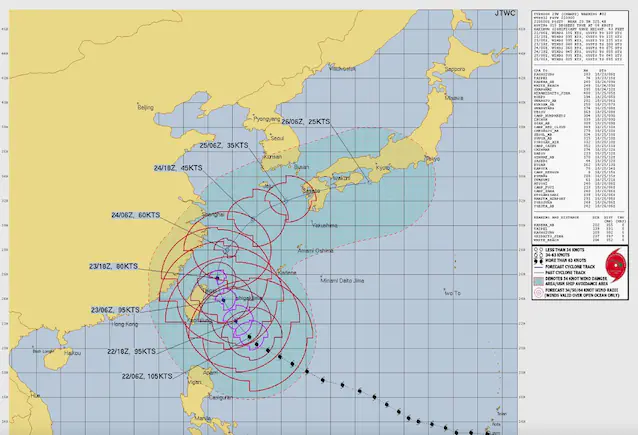
The moment of closest approach to the island will take place in two phases on the day of Friday 23 October:
Southern Taiwan (Kaohsiung): the center of the storm will pass at the minimum distance of approximately 330 km around 06:00 UTC (2:00 pm local time).
Northern Taiwan and capital (Taipei): the most critical phase for the metropolitan area will occur on Friday evening, around 15:00 UTC (23:00 local time)when the eye of the typhoon will pass by approximately 137 km east of Taipei, hitting the north of the island with its most violent quadrant.
Champi will therefore be felt decisively in particular on the east coast of Taiwan maintaining sustained winds close to 95 knots (175 km/h) but without making a real landfall, and then continuing towards the East China Sea. Between 60 and 72 hours, the impact of warmer waters and the transition to higher latitudes will initiate the extratropical transition of the system towards southern Japan.
Extreme rainfall and hydrogeological risk
In addition to the violence of the gusts and the rough sea, the main danger for the population is linked to the rain. Taiwan has a complex orography with a central mountain ridge (similar to Italy) but with peaks above 3,000 metres, a natural barrier against which the typhoon’s moisture-laden currents will impact.
This “orographic stau” will favor torrential and persistent rainswith accumulations in internal areas that could reach record levels 1,000 mm over the course of the event, approximately 48 hours. Such a volume of water on steep slopes critically increases the risk of landslides, mudslides and mudslidesthreatening to isolate mountain population centers.
What is it stau orographic? The orographic stau it is the forced lifting of a mass of moist air forced up the slope of a mountain. Going up, the air cools, the condensation intensifies and generates abundant and persistent precipitation on the side exposed to the wind.
Canceled flights and evacuations
The inconveniences to transport and daily life are already evident. For safety reasons, airlines have already canceled over 100 commercial flights to and from the main airports of the island, while many maritime and rail connections along the most exposed routes have been temporarily suspended. The government has made an appeal to the population recommending stay indoors and strictly avoid coastal areas and mountainous slopes. Preventive evacuations were triggered for hundreds of residents in several at-risk locations.