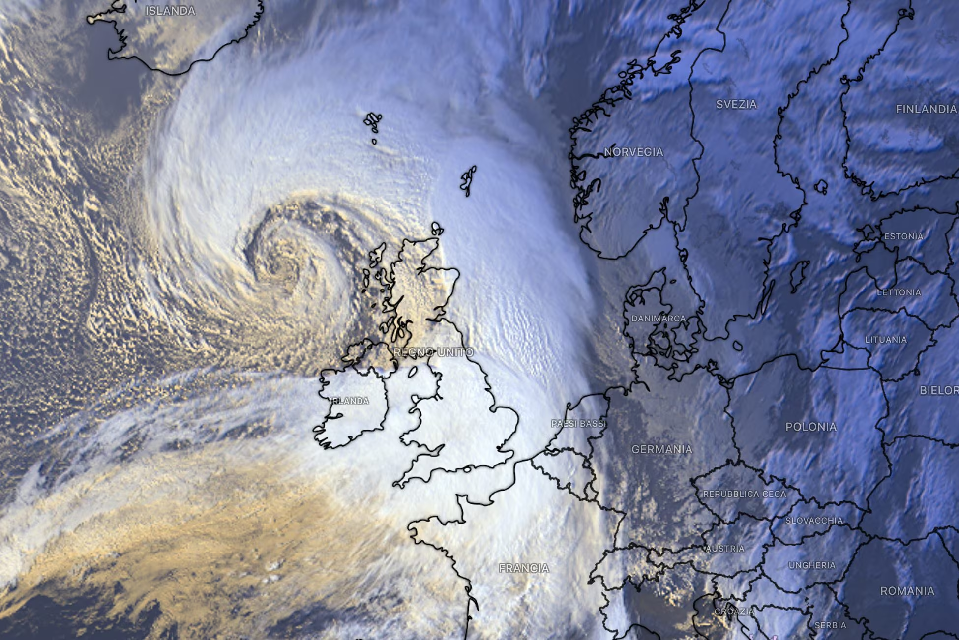
The Atlantic storms Austen and Boelo hit Central-Northern Europe causing blackouts in over 150,000 homes, violent gusts of wind up to 135 km/h, injuries and disruption to air, rail and maritime transport. The disruptions mainly affected the United Kingdom, France and Germany, while no significant direct effects are expected in Italy.
Autumn suddenly changed gear, revealing its harshest and most dynamic face in a disruptive way. In the last few hours, a veritable train of intense Atlantic disturbances, christened by the international meteorological services with the names of Austen and Boelohit hard across much of the Central-Northern Europe. The budget drawn by the local authorities is heavy: over 150,000 homes remained completely darkinterrupted connections, airports in chaos and a list of injuries that testifies to the extraordinary violence of the ocean winds.
This is a phase of severe bad weather which confirms that the season of great autumn storms has officially come into full swing, fueled by very strong thermal contrasts between the arctic and temperate latitudes of the Old Continent.
But what impact will these immense depression structures have on our country? Weather forecasts outline a clear and marked continental divide: Italy will not suffer any direct effects from this train of Northern European storms, thanks to the providential and protective return of a solid high pressure field.
The fury of Austen and Boelo: damage and bad weather report in Europe
The sequence of extreme events began with the transit of the storm Austenwhich began to hit the south of England and the Atlantic coasts of France hard in the second half of last week, also involving Central-Northern Italy with its tail and bringing snow back to the Alps, to then leave room over the weekend for the arrival of the subsequent and even deeper depression called Boeloclearly evident in the cover image.
This second system hit the British Isles and central Europe in full between 24 and 25 October, prompting the British National Meteorological Service (Met Office) to issue high level alerts, warning the population of a concrete risk to public safety caused by wind and storm surges along the coasts.
The most recent data released by the authorities and international news agencies provide a detailed map of the damage and critical issues recorded over the weekend:
- Record gusts and chain blackouts: in the United Kingdom, and in particular in the county of Argyll and Bute in the west of Scotland, the anemometers recorded furious gusts that reached peaks of well 135 km/h. The fall of centuries-old trees and the breaking of high voltage cables caused widespread interruptions to the electricity grid. Overall, the temporary blackouts isolated approx 82,000 homes in Great Britain, almost 60,000 in France and at least 10,000 in Germany.
- Chaos in transport and in the skies: hundreds of commercial flights and ferry connections were cancelled, delayed or urgently diverted. Serious disruptions have been reported at major airports such as Schiphol airport in Amsterdam, while railway networks in Scotland, England and Sweden have suffered prolonged blockages due to tracks blocked by branches and debris. Local maritime services were also suspended and heavy vehicles were blocked on exposed bridges, such as the famous bridge over the Great Belt in Denmark.
- Injured people and rescue interventions: the violence of this worsening weather has not spared urban centers. In Brussels, the sudden fall of large trees injured four people. In Germany, in the town of Naststätten near Frankfurt, two people were seriously injured when construction scaffolding collapsed and was literally uprooted by Austen’s gusts during an autumn market. Similar scenes, albeit with limited material damage, occurred in Denmark, Norway and the Baltic areas.
To understand the genesis of this double storm we must observe the barometric configuration over the North Atlantic Ocean. The combination of a very tense zonal flow and a vigorous polar jet allowed the formation of extratropical cyclones particularly deep. When these structures move rapidly towards temperate zones, encountering air masses with very marked thermal gradients, they undergo a process of explosive cyclogenesis and the pressure at the center drops dramatically in a few hours.
Will there also be effects in Italy due to the storms?
While Central-Northern Europe is forced to deal with the damage count, Italy will remain firmly protected from this extreme bad weather scenario.
Already in these hours one is underway decisive and vigorous comeback of subtropical high pressure which will progressively take possession of the Mediterranean basin. This anticyclonic structure will act as a protective shield from the Atlantic flows, guaranteeing a phase of prevailing atmospheric stability, clear or partly cloudy skies and pleasant temperatures, in line with or slightly higher in maximum values than the climatic averages of the period over much of the Peninsula.
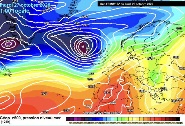
However, it is worth pointing out that the protection will not be absolute. Along the eastern edge of this high pressure shield they will continue to flow cooler, northern currents. These infiltrations will marginally touch our southern regions and, in particular, the southern Adriatic sides but with few noteworthy phenomena.