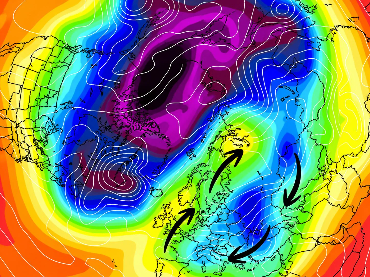
Winter early in November? The models glimpse currents from the north-east, but talking about extreme cold at 200 hours is not science. The explanation of air masses: not all are the same.
In recent days there has been a succession of bombastic headlines online regarding the arrival of harsh winter, snow and the famous “burian”, or rather, Buran. A few long-term weather cards dyed purple or dark blue are enough to trigger the panic or enthusiasm of weather lovers. snow on social media and in some online publications.
An obligatory linguistic clarification, often confused on the web: the correct form is Buranderived from Russian and the Turkish-Tatar languages to indicate a snowstorm or strong wind coming from the steppes. The term “burian“, which spread in Italy probably due to phonetic interference with the local word “buriana”, which indicates a sudden storm of short duration, in Russian (бурьян) actually indicates something completely different, namely weeds or weeds!
But what do the forecast models really say for the first half of November? And above all, why should 200 or 300 hour forecasts be handled with kid gloves? Let’s see what’s true and, immediately after, explore the physics of the atmosphere to understand how cold air masses really work.
What the models say for the first half of November 2026: snow and temperature drop
Analyzing the real trends of the main data centers for the beginning of November, the scenario is much more nuanced than the headlines circulating:
- Tendency to return from the East: mathematical models actually show a baric disposition that could favor a weakening of the Atlantic flow and the triggering of cold currents retrograde from East/North-East;
- Probable temperature drop: it is plausible to expect a more rigid and crisp climate than the seasonal averages, with the arrival of cooler or colder air from the north-east which will bring a first taste of winter especially along the Adriatic slopes;
- Snow on the plains and intense frost? Talking today about snow on the coasts or about “Siberian Buran” weeks in advance is completely premature.
To have reliable confirmation of a possible cold outbreak, we will have to wait for the short-term simulations (72-96 hours), when the high-resolution models will precisely define the trajectory of the currents. It is very likely, however, that Eastern Europe could experience a rather cold first half of November with temperature values below the average for the period.
The myth of the 200-300 hour forecast: the limit of atmospheric chaos
When we go beyond 5-7 days of temporal distance (i.e. beyond 120-150 hours), the Earth’s atmosphere behaves in all respects like a nonlinear chaotic system.
The supercomputers of international computing centers (such as the European ECMWF or the American GFS) continuously process billions of data. To do this, they use “ensemble runs” (or spaghetti diagrams): they do not launch a single prediction, but dozens of parallel simulations introducing very small variations in the initial conditions.
After 200 or 300 hours, these guidelines tend to fan out dramatically. Just a few kilometers of movement to the location of a high pressure structure is enough to transform what on paper looked like a freezing irruption into a simple return of moderate Grecale winds, or to divert the cold air towards Turkey or European Russia.
Proclaiming an intense cold wave two weeks away as “certain”. it’s not meteorology, but an editorial gamble.
The physics of the Buran: a continental push against the current
Saying that “the Buran is coming” means evoking one of the most extreme meteorological configurations for Europe. The Buran it is not a simple cold snap, but an icy storm wind linked to a specific air mass: thecontinental polar air (coming directly from the Siberian plains).
To ensure that the Siberian film air (a cushion of very dense and freezing air that forms in the lower layers due to nocturnal radiation) is able to travel in an anti-zonal direction towards Europe, basically two large synoptic tiles:
- Voejkov Bridge: the Azores High Pressure extends towards Scandinavia, merging with the Russian-Siberian Thermal High Pressure, creating an endless baric wall.
- Retrograde (or antizonal) motion: the enormous pressure difference pushes the air flow from east to west, in a direction contrary to the normal Atlantic zonal circulation.
It is precisely the imposing pressure gradient generated by this configuration that “forces” the movement of the freezing air reservoir towards our latitudes. Contrary to what is often thought, there is no need for a Mediterranean “depression coupling” for the Buran to set in motion: cold air travels driven entirely by continental dynamics. The possible genesis of a low depression in the Mediterranean occurs only at a later time as a consequence or co-factor of the impact of this flow on the milder waters of the south, transforming the dry outbreak into a severe bad weather event.
Not all cold is the same: the “identity card” of air masses
One of the most common mistakes in sensational news is to call any breath of fresh air in autumn or winter “Buran”. In atmospheric physics and synoptic classification, cold air masses are divided into four main categories:
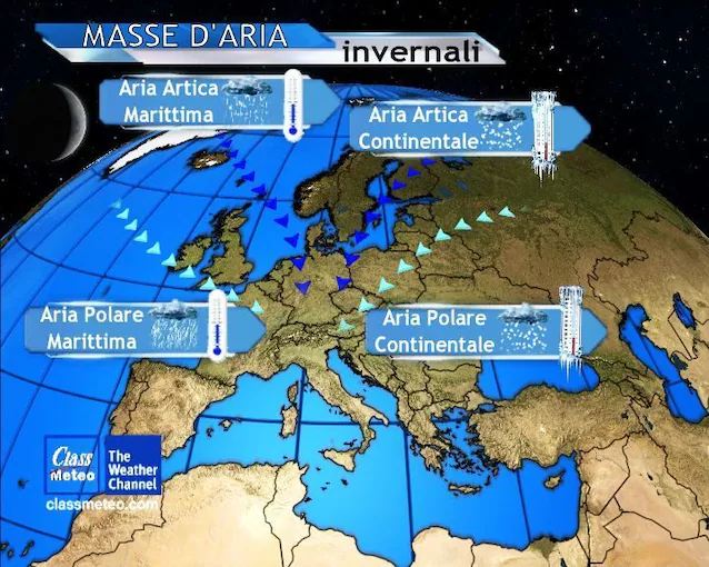
- Maritime Polar Air: it originates at the high latitudes of the North Atlantic and reaches Italy after flying over the ocean. It’s an aria cold especially at altitude, but not freezingwhich in contact with the sea surface is loaded with heat and humidity in the lower layers. Precisely for this reason it is very humid and unstable: triggers strong convective motions and gives rise to rain, thunderstorms and even very heavy snowfalls in the mountains, despite not having the characteristics of extreme continental cold;
- Arctic-Maritime Air: comes directly from the North Pole passing through the Ice Sea and the Norwegian Sea. When it breaks into the Mediterranean, it generates severe depressions with rapid temperature drops, hail showers/graupeln and snow up to hilly or low altitudes;
- Arctic-Continental Air: originates in the polar belts of northern Russia and north-eastern Scandinavia. Travels across continental snow and ice surfaces, presenting itself extremely cold, stiff and drywith negative isotherms at all altitudes which cause temperature drops and intense frosts;
- Polar-Continental Air: it is the filmy air accumulated in the vast plains of Eastern Europe and Siberia east of the Urals. It is the air mass characterized by exceptional dryness in the lower layers and extremely cold temperatures close to the ground. When it is pushed westward by strong pressure gradients (retrograde motion), it gives rise to freezing wind storms and contrasting snowfalls along the exposed slopes or right up to the coasts in contact with our seas.