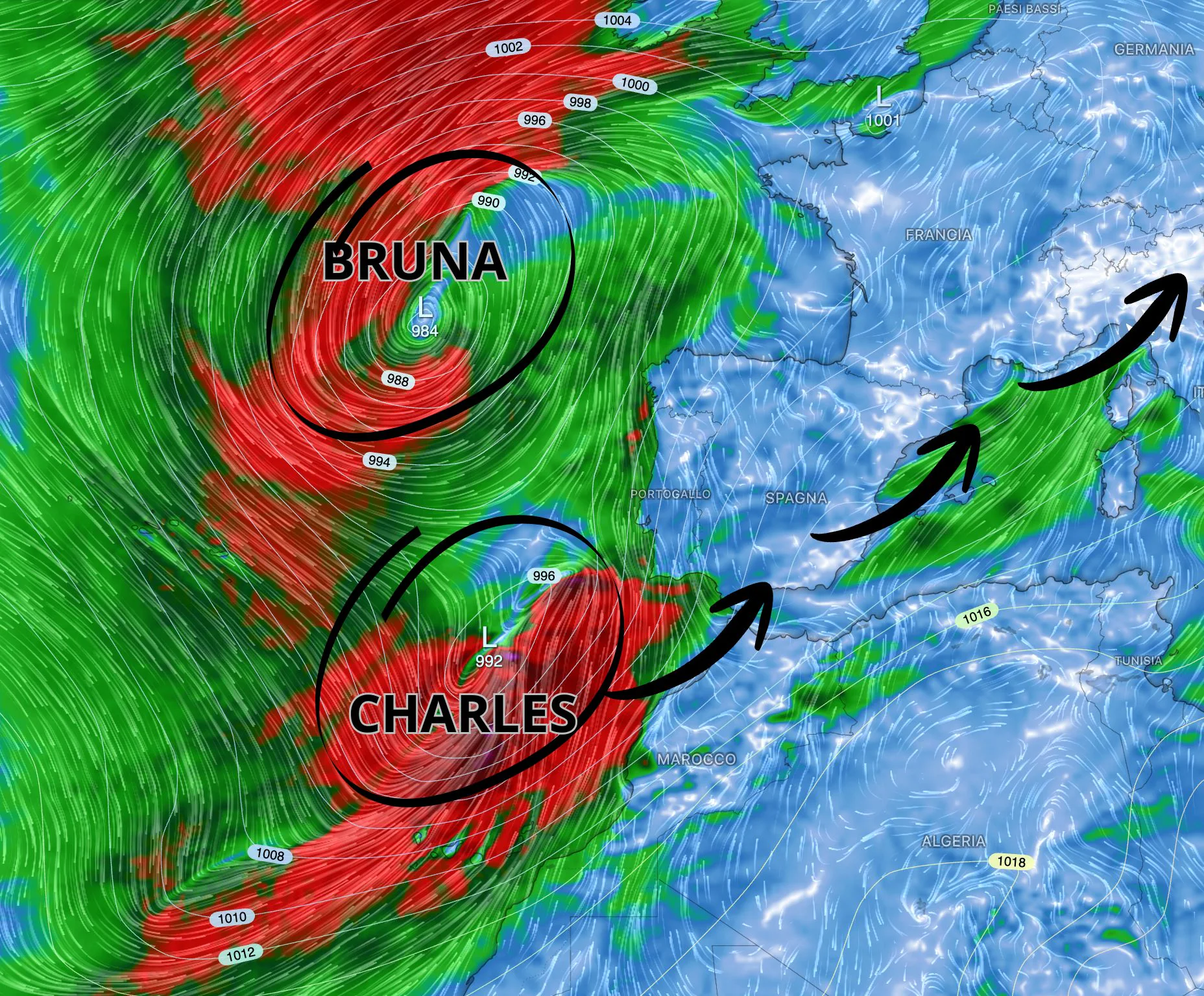
Cyclone Charles arrives: torrential rain, accumulations over 250 mm on saturated ground and rough seas with waves of up to 3 metres.
While the Iberian Peninsula deals with the effects of Cyclone Charles, a deep depression of subtropical origin which between Portugal and Spain dumped torrential rain and winds over 100 km/h, the countdown has begun for Italy. This intense disturbed systemfed by warm and moisture-rich air masses coming from the low Atlantic latitudes, is in fact moving its center of gravity towards the central Mediterranean. The situation promises to be particularly delicate for our peninsula: after the first signs of instability on Wednesday 11 November, Charles’ real impact will occur mainly between Thursday the 12th and Friday the 13thtriggering a significant worsening of weather conditions in much of the Centre-North and the Tyrrhenian sector and wiping out the San Martino summer,
Where Cyclone Charles will hit: between Levante Ligue and upper Tuscany
The bad weather phase comes to the fore, concentrating its forces more immediate effects along the northern Tyrrhenian sector. The eastern margin of the Atlantic trough (i.e. the disturbance) is sending intense unstable impulses towards the western Italian seas and is already affecting the western areas of the country.
Eyes are on the Central-eastern Liguria and upper Tuscanywhere the humid flow is already causing widespread rain and persistent showers today, Wednesday 11th. The yellow alert is already in force in these areas and rain gauges are recording significant accumulations, which close to the Apennine ridges and in the mountainous areas could exceed 200 mm cumulatively already in this first phase, laying the foundations for the subsequent and heavier thrust on Thursday and Friday.
The Civil Protection will issue the relevant alerts in the next few hours.
Warning for heavy rain and thunderstorms from Thursday and Friday: forecast
Starting from Thursday 12 NovemberCyclone Charles will enter the heart of its action on Italy. The depression will trigger a vigorous call of southern winds (with gusts of Scirocco and Libeccio reaching 70-90 km/h), conveying a real “atmospheric river” of humidity against the mountains.
The bad weather will affect the entire Central-North, with possible critical issues in Liguria, Tuscany and Triveneto. But be careful: the rainfall will not spare the other regions, in particular the central Tyrrhenian ones, which will remain in the sights of the showers even on the day of Friday 13thwhen the cyclonic pivot will persist close to the Peninsula. It will go much better in Sicily, the Ionian areas and the lower Adriatic.
Added to this is the evolution of snow level: due to the initial mild call, the flakes will only fall at very high altitudes, above 2000-2200 meters on the Alps; however, with the influx of progressively colder air at the back of the depression, the snow level will drop to 1400-1600 meters on Friday morning.
Saturated soils, rough seas and accumulations above 250 mm
The main concern for land holding arises from the critical combination between the total volume of rainfall and the state of the soil. Model simulations indicate that by Friday morning the overall accumulations will be able to exceed 250 mm behind the Ligurian East and upper Tuscany.
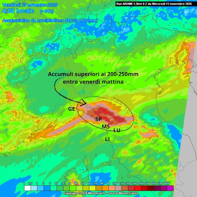
Since it has been raining continuously for days and the sun is unable to dry the soil, the soils are saturated and act like sponges incapable of holding more water: the additional millimeters will be able to feed runoffs And full of waterways.
The seas will also be heavily affected by the storm: on Friday 13th the sea will be rough, with storm surges and waves up to 3 meters high from the South-West (Libeccio) along exposed coasts.
What happens from Sunday 15 November: the unstable flow returns
After the paroxysm of Thursday and Friday, the day of Saturday 14 November will grant one temporary break and a general attenuation of the phenomena thanks to a partial improvement.
However, bad weather will not be archived: medium-term maps confirm that as early as Sunday 15th an unstable south-westerly flow will returnready to bring rain and scattered instability, particularly in the Tyrrhenian regions.