In Europe, from 2022, it is in place the most important passive seismology experiment never made. It’s that of INGV AdriaArray project (National Institute of Geophysics and Volcanology), which made it possible to study the internal structure of the Earth in the central-Mediterranean area analyzing the propagation of seismic waves produced by natural phenomena such as earthquakes. This allowed us to understand theevolution of the Adriatic platea small lithospheric plate between Africa and Europe, ei earthquakes associated with it. A dense network of seismic stations and sensors was used for the project. The information collected is shared with the entire international scientific community, since only global collaboration allows us to fully understand the geological processes that affect our planet.
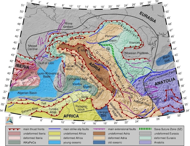
The area studied by the AdriaArray project: the Adriatic plate
There Adriatic plate or Adriathe subject of study of the AdriaArray project, is a microplate located between Africa and Europe. It extends along the Po Valley-Veneto and the Adriatic Sea and from a tectonic point of view it constitutes a promontory of the African plate. The collision between the Adria and European plates led to the formation of the Alpine chain to the north, while its sinking (subduction) towards the south-west under the Italian peninsula is linked to the formation of the Apennines. In addition to the Alps and the Apennines, the microplate is delimited to the north-east by the Dinarides mountain range. Both collision and subduction processes are responsible for the deformation of the crust and gods earthquakes occurring in the region. The aim of the AdriaArray project is to better understand the crustal dynamics underlying the seismicity of the area. To do this, it was necessary reconstruct the structure of the crust and mantle under the central-Mediterranean area.
The technology used
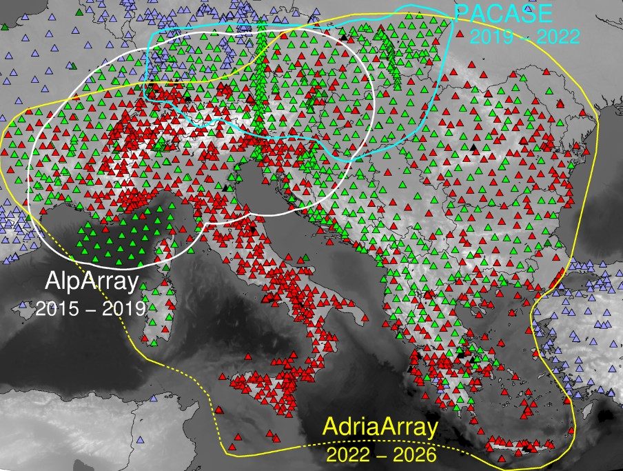
The project is based on the use of the so-called passive seismologywhich it plans to analyze how seismic waves propagate produced by earthquakes or by environmental seismic noise (the set of vibrations of natural origin not linked to earthquakes) without resorting to artificial seismic sources. In particular, we study the speed with which seismic waves pass through the subsoilwhich depends on the characteristics of the materials they encounter. To do this, they were used over a thousand permanent seismic stations and hundreds of temporary sensors spaced a few tens of kilometers apart, which guaranteed almost homogeneous coverage of the central-Mediterranean area. The density of this seismic network allows us to intercept even very low magnitude earthquakes, which in the past could not be identified, and consequently to better recognize active faults. The result of these investigations is adetailed image of the underground structure.
The importance of the project: the strengthening of seismic networks in Italy
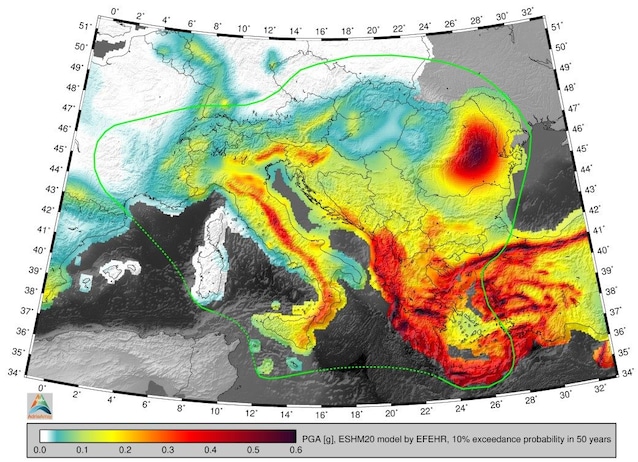
The project also allowed for improve monitoring in regions that present some critical issues, strengthening the permanent seismic networks: la Po Valleyin which the high level of anthropic noise and the characteristics of the surface sediments make the installation of highly sensitive stations complex, and the Sardiniawhere the low seismicity in the past did not encourage the installation of a large number of stations. In general, all information obtained within the framework of the AdriaArray project will be useful for improve seismic hazard estimates and so the prevention of seismic risk in the area of interest. Another very important aspect of this experiment is the fact that it is based on a collaboration at an international level. In fact, the project involves dozens of institutions and hundreds of researchers from numerous European countries. Furthermore, the information collected is shared with the entire international scientific community: in this way it will be possible to study complex processes that data collected at a national level alone would not be sufficient to understand.