
On the surface, the Po Valley appears as an expanse of 46,000 square kilometers completely flat. However, by exploring the subsoil up to several kilometers deep, geology reveals the presence of real folded and crumpled mountain ranges. Under the visible layer dominated by fields, canals and population centers, a package of sediments (gravels, sands, clays and marine deposits) which reaches thicknesses between 3,000 and 5,000 metres. At the base of these sub-plain layers, laid down by rivers over the last million years, lies the geological skeleton of the plain: buried reliefs that move and continue to grow.
Located in Nonorthern Italythe Po Valley is a vast natural basin enclosed between the arch of Alps (to the north and west), the chain of Apennines (to the south) and the Adriatic Sea (to the east). Its territory mainly includes four regions: Piedmont, Lombardy, Emilia-Romagna And Veneto (as well as fading to the east into the contiguous Veneto-Friulian plain).
How we discovered the underground mountains
There mapping of these buried mountain ranges is a direct result of the search for hydrocarbons (oil and gas) started in Italy in the second half of the twentieth century by AGIP (now ENI). To understand the structure of the subsurface, geologists and geophysicists have used two main tools. The first is the seismic reflection: A controlled seismic wave is sent deep down, and when it encounters the boundary between two layers of rock with different physical properties (such as clay and limestone), some of the energy bounces back to the surface, similar to light on a mirror. The sensors on the surface record the round trip times, allowing us to reconstruct a real ultrasound of the subsurface up to 8-10 km deep.
The second fundamental tool is i exploration wells. These are perforations with diameters of only 10-15 cm, however pushed up to 5-7 km deep, which represent the only means capable of recovering physical rock samples and measure direct geological data. The intersection between thousands of kilometers of seismic profiles and well data has made it possible to systematize knowledge of the Po Valley subsoil, revealing enormous folds and buried faults.
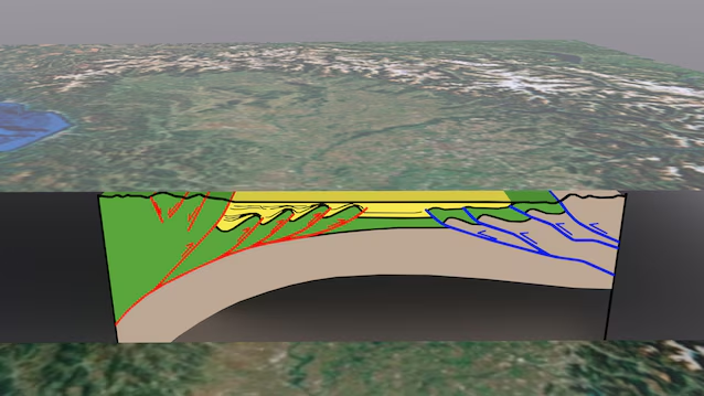
The anatomy of the subsurface: a “tectonic sandwich”
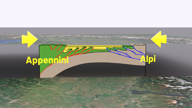
From a geological point of view, the Po Valley is found in a structural grip between two mountain chains that advance from opposite directions, forming a double-faced system.
To the south the Apennine domainwhich generates a thrust towards the north/northeast, translating in depth into a series of folds associated with reverse faults (the “foot-Apennine folds”). To the north the Alpine Dominationwhich pushes towards the south: the uplift of the Alps, which occurred between 29 and 10 million years ago, has in fact created mirror-like compressive structures that extend below the plain.
From marine gulf to plain 870,000 years ago
The reason why these mountains are buried is related to formation of the Apennines themselves. The clash between the Sardinian-Corsican microplate and the Apulian platform raised the Apennine chain, whose enormous weight flexed the earth’s crust, generating a deep depression in front. In the Pliocene (between 5 and 3 million years ago), this basin was occupied by the sea: the Adriatic Sea extended almost to present-day Genoa, and the Milan area was a real marine gulf. Progressively, the sediments transported by the Po river and from its tributaries they filled the depression. The definitive transition from a marine to a continental/fluvial environment occurred approximately 870,000 years ago.
Living mountains and seismicity
The structures buried beneath the Po Valley are not static, but continue to exist deform. The Mirandola Anticline, one of the most important buried folds in the Emilian sector, is located 5-6 km deep and grows at a rate of approximately one millimeter per year. This constant rising has forced the Po river, over the last 10,000 years, to progressively move its bed northwards. These profound movements manifest themselves on the surface through the earthquakes. A significant example is the seismic sequence of Emilia of May 2012 (with earthquakes of magnitude 5.9 and 5.8). Despite the initial technical debate on a possible anthropogenic trigger, the international scientific community frames these events as natural tectonic phenomenachildren of the Italian crustal dynamics. The deep geology of the Po Valley demonstrates in fact that the landscape is not a static legacy of the past, but the expression of a present that moves over extremely dilated times.
