
A violent earthquake of magnitude 6.0 struck the eastern region ofAfghanistanabout 27 km from the city of Jalalabadone of the most populous in the country, yesterday at hours 23:47 (local time). It was a very superficial earthquake – we are talking about a hypocenter located only 8 km deep – whose effects on the surface have been devastating: according to what reported by To Jazeerathe government spokesperson Mawlawi Zabihullah Mujahid has announced a provisional budget at the press conference of 800 victims And 2500 injured, even if the number is destined to climb in the next few hours.
These data are linked to a series of factors: in addition to the intrinsic energy of the earthquake, it should be considered that the earthquake occurred at night, that the area is mountainous (thus becoming complex for rescuers) and very poor, therefore the buildings have not been built following particular anti -seismic criteria (“the houses are built essentially with mud”, he said Thamindri de Silvanational director of World Vision Afghanistan). The union of all these factors caused an extremely high number of victims and wounds. For help, the Taliban government is asking for help from international organizations also given the complexity due by the landslides that have blocked several paths.
The earthquake was also felt distinctly in distant areas 140 km And, at the moment, the information we have regarding the event is rather fragmented: clearer details will emerge in the next few hours. But from the geological point of view what were the causes? To have a clearer view we can analyze the following map provided by the United States Geological Survey (USGS):
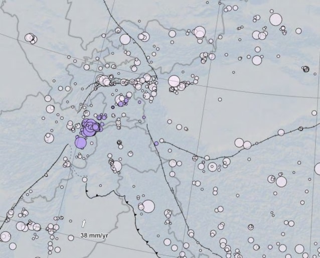
The area affected by the earthquake is represented within the image, whose epicenter It is located near the purple circles. Each point on the map represents a historical earthquake occurred in the area: the larger the circle and the higher the magnitude, while the color is proportional to the depth. As we can see in this area there are numerous black lines: each represents a fault system. Their presence in such a high number therefore tells us a rather complex geological situation, linked – to the macroscala – to the collision between the Indian plaque and that Eurasian. To be clear, it is precisely this collision that in the past has generated the mountain range of the Himalaya!
The accumulation of stress in this area gives life to earthquakes with a rather high magnitude, as happened in today’s case.