In all likelihood El Niño is about to return: the anomalous warming of the waters of the equatorial Pacific, capable of influencing the weather and climate of large areas of the world, could already begin to June. According to the latest update of Climate Prediction Center of NOAA, there is a probability of82% that El Niño begins in the May-July 2026 quarter, and the 96% probability that it will continue until the December 2026-February 2027 quarter.
What makes this El Niño particularly “newsworthy” is the possibility that it will be this year particularly intensepossibly even the strongest ever recorded. Headlines like “Super El Niño coming soon” with forecasts of an exceptionally hot summer in Europe. “Super El Niño” is a journalistic expression, not used by official meteorological agencies, which indicates a warming of the Pacific by at least 2°C compared to the average, therefore a very high intensity event.
If it is true that some models predict an event of that magnitude, official bodies such as NOAA, WMO (World Meteorological Organization) and ECMWF (European Center for Medium-Range Weather Forecasts) call for greater caution: Although the probability that El Niño will be particularly strong this year is high, it still remains substantial uncertainty about the intensity of the peak.
Even on the forecasts for this summer it would be necessary to go with the feet of lead: historically the effects of El Niño are felt most strongly in the year following the peak, not during the same year, and Europe is not among the regions most directly affected by the phenomenon. In short, at the moment everything is still to be seen. To have more certain data we will have to wait until next monthwhen the picture is clearer. Only then will it be possible to make more reliable predictions about what to expect from El Niño in 2026 and 2027.
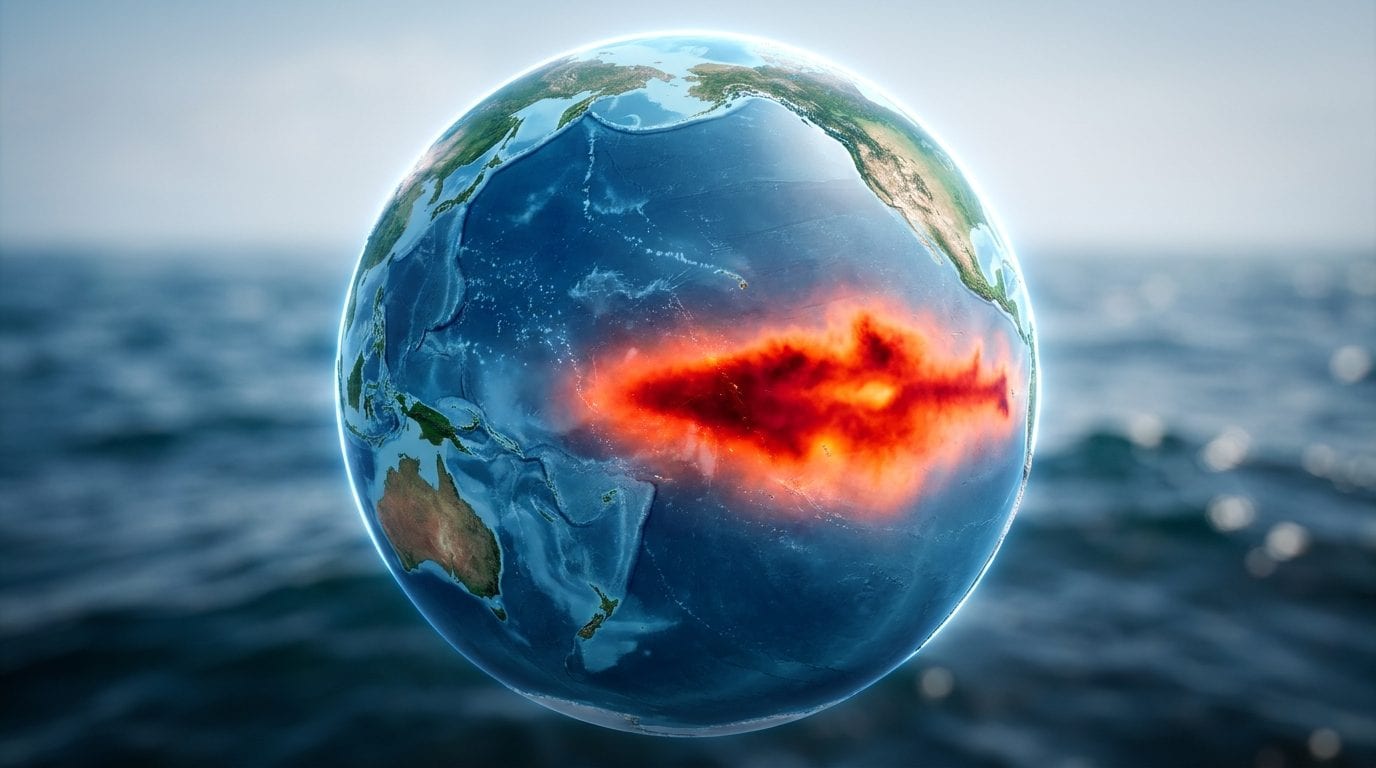
What is a “Super El Niño” and how ENSO works
El Niño works more or less like this: in the Pacific, the trade winds they blow from east to west along the equator, pushing warm surface waters toward the western Pacific. This shift brings up cold deep waters off the coast of South America, lowering the surface temperature of that part of the ocean. When the trade winds weaken sufficiently, this phenomenon is reduced and the waters of the Pacific near the South American coast warm up.
From a technical perspective, El Niño is a warming of at least 0.5°C compared to the seasonal average for a period of at least 5 months. Its arrival alters the distribution of precipitation, the frequency of hurricanes, global temperature and the stability of many ecosystems on a planetary scale.
El Niño does not appear every year: its cadence varies 2 to 7 years approximately and lasts approximately 9 months (with some variability). The last episode ended in the spring of 2024, after a cycle that began in the summer of 2023. What is journalistically nicknamed “Super El Niño” (an event with a thermal anomaly above +2 °C) is rarer: the latest cases occurred in 1982-1983In the 1997-1998 and in 2015-2016.
The forecast for 2026: El Niño is almost certain, but its intensity is not
The signs that El Niño is activating are already underway. NOAA reports that equatorial subsurface temperatures have increased for sixth consecutive monthwith significant and widespread anomalies across the equatorial Pacific. The winds are also changing: westerly wind anomalies (the typical atmospheric signal of the start of El Niño) are already detectable both in the western Pacific at low altitude and in the central and central-eastern Pacific at high altitude.
NOAA’s latest multi-model forecast predicts that El Niño could form as early as June 2026 and persists throughout the boreal winter. Some models, such as the CFSv2’s National Center for Environmental Predictionthey even predict that 2026 will be the strongest “Super El Niño” ever recordedexceeding those of 1982-1983, 1997-1998 and 2015-2016 in thermal anomalies. We can see it in the graph below.
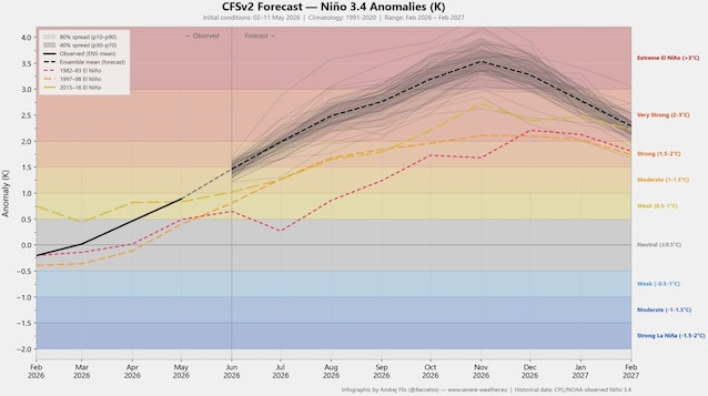
But the truth is that for the moment they remain strong uncertainties about how strong El Niño will be in 2026. As reiterated by NOAA, historically “Super El Niños” show significant coupling between ocean and atmosphere during the summer, but we do not yet know whether this will occur in the coming months. The ECMWF adds a further note of methodological caution. Seasonal patterns, in fact, are subject to particular uncertainties at this time of yeardue to the natural variability of the changes in the tropical Pacific climate system between March and May are naturally less predictable than at other times of the year. This is why El Niño forecasts begin to be reliable starting in June.
Having made these necessary premises, let’s now see what they actually say latest official forecasts of NOAA, which we can see in the graph below.
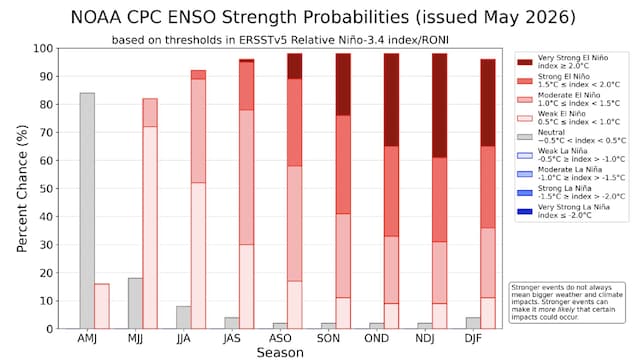
This graph tells us first of all that the arrival of El Niño is practically certain. The gray bars indicate the probability that this phenomenon will not occur, and as you can see they are very low. The color scale indicates, from lightest to darkest, the expected intensity of El Niño: respectively «weak» (from +0.5 °C to 1 °C), «moderate» (from +1 °C to +1.5 °C), «strong» (from +1.5 °C to +2 °C) and «very strong» (at least +2 °C, i.e. the so-called “Super El Niño”). As can be seen, the possibility of a “Super El Niño” begins in July and increases in probability until it reaches a peak of almost 40% in November. In short, a “Super El Niño” in 2026 is more than possible, but anything but certain. Overall, however, forecasts indicate that El Niño is likely to be particularly intense this year.
What could happen in Europe
The headlines you are reading these days about a torrid summer in Europe do not take into account a fundamental fact, reiterated by all the main meteorological bodies: having a stronger El Niño does not necessarily mean there will be more intense weather effects. Stronger El Niños may only make certain effects more likely, but they do not guarantee them. This is an important distinction: we are talking about variation in the probability of certain scenarios, not deterministic predictions.
Having said this, the scientific literature and historical data provide some general indications for Europe. El Niño years have been associated with higher temperatures in the European region: it is believed, for example, that the latest El Niño contributed to making 2024 the warmest year on record in Europe. On this basis it is reasonable to expect that next year, i.e. 2027, may present above average thermal conditions, with a increased likelihood of prolonged heat waves and extreme weather events.
To say anything more, however, right now would only mean venturing into conjectures and speculations. As said at the beginning, for now we just have to wait until next month when the data will be more precise and will be able to provide us with more reliable indications on the consequences of El Niño for this year and next.