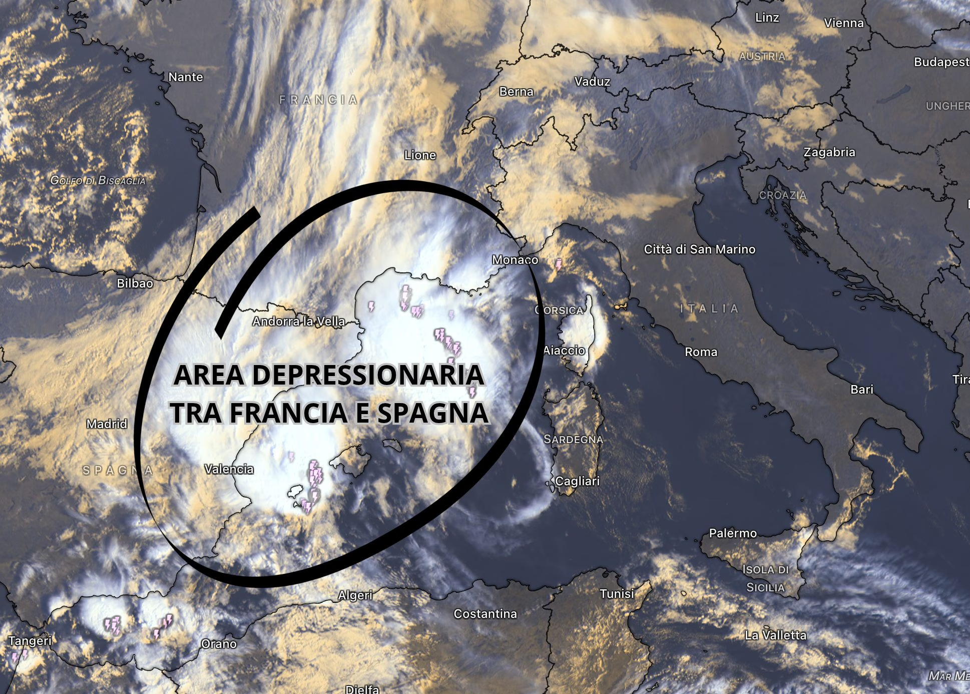
A vast and deep depression structure of Atlantic origin is moving decisively towards Italy. This disturbed system, which in the last few hours has already affected a large part of Western Europe, bringing widespread rain, flooding and various hydrogeological criticalities between Spain and France, with the dramatic news of a victim, is organizing itself and compacting further before directly affecting our peninsula between the day of Tuesday 20th and the morning of Wednesday 21st October. For the day of today, Monday 19 Octoberthe Department of Civil Protection has meanwhile issued a statement of yellow alert for hydraulic risk, storms and hydrogeological risk involving 6 Italian regions: Liguria, Piedmont, Tuscany, Sardinia, Sicily and Calabria. It should be remembered that this warning refers to the next few hours and that it will be updated and modified in the next official bulletins based on the evolution of the storm front expected for Tuesday and Wednesday.
The trajectory followed by this sacturing will recall southern humid flows in the lower layers. The most active phase of this worsening will begin to be felt in the North-West and in particular in Liguria as early as Tuesday afternoonand then rapidly extended to the rest of the northern regions and to a large part of the Centre-South, completing its transit over the entire peninsula, including the central-southern Adriatic regions, by afternoon on Wednesday 21 October.
Details on Atlantic disturbance and rainfall in Italy: the regions
As usually happens with the arrival of Atlantic disturbances, the Tyrrhenian coastline and the hills close to the sea will be the areas most exposed to the most intense phenomena. Particular attention should be paid to Liguriawhere the soil is already highly saturated due to recent rainfall: a Genoajust in the last few hours, heavy rains have caused the failure and collapse of an imposing containment walltestifying to the fragility of the territory after the accumulations exceeding 150 mm recorded between the capital and the Gulf of Tigullio.
In addition to Liguria, there are others under close observation Tuscany And Laziowhere storm nuclei capable of discharge may develop within the perturbed front over 100 mm in just 2 hourswith rainfall in the nature of a real storm that could trigger local urban flooding, crises in drainage systems and violent gusts of windwith gusts that under the more structured storm cells can easily overcome the 80-90km/h.
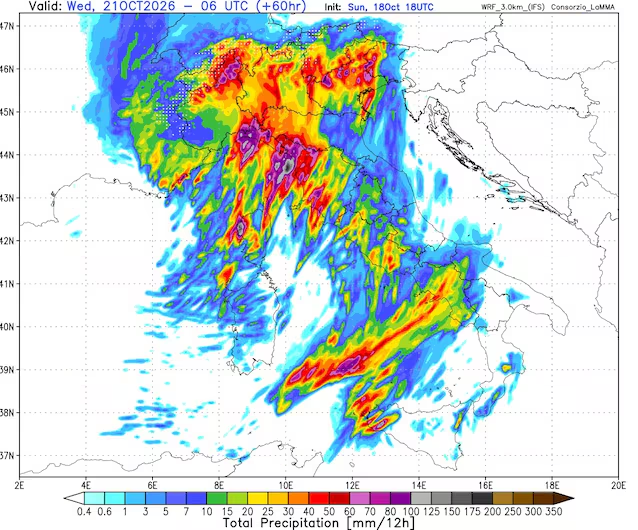
The situation undoubtedly deserves a specific focus Liguriaboth because the soil is already highly saturated due to the huge accumulations of rain (>150mm) that fell on Sunday 18 October between the areas east of Genoa and the Gulf of Tigullio, and because before the arrival of the actual front a stationary storm line could activate in the central sector, approximately between the Savonese area and the capital.
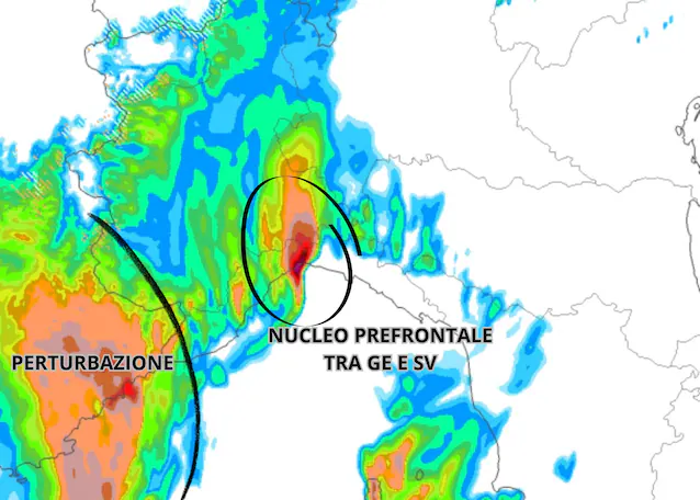
In the rest of Italy, however, the passage of the disturbance will tend to last more quickly, estimated at around 1-3 hours per single zonebut it will still be accompanied by locally very intense showers and a sudden drop in temperature.
Libeccio winds, storm surges and the trend for the weekend
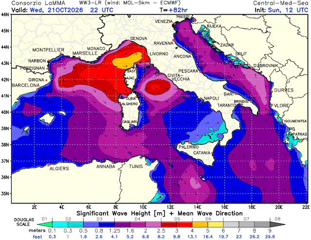
Accompanying the entry of the disturbance will also be a marked intensification of southern ventilation. In particular, sustained winds will be activated Scirocco with gusts up to 60-80 km/h (higher peaks in the presence of intense thunderstorms) which will blow along the Tyrrhenian and island basins. Subsequently, following the passage of the perturbed front, an intense flow will be triggered Libecciocausing storm surges with waves between 3 and 4 meters on the Ligurian East and peaks that in front of upper Tuscany and the Livorno coast will be able to reach and even surpass the 5 meters high.
After a temporary and short break that seemed to be looming for the day of Thursdaythe meteorological situation in our country will change rapidly again. In fact, medium-term projections indicate that between Friday and Saturday the arrival of a will make its way new perturbed impulsewhich will once again see the Levante Ligure on the front line to receive the most abundant rainfall, thus confirming an extremely dynamic autumn period and to be constantly monitored through official bulletins.