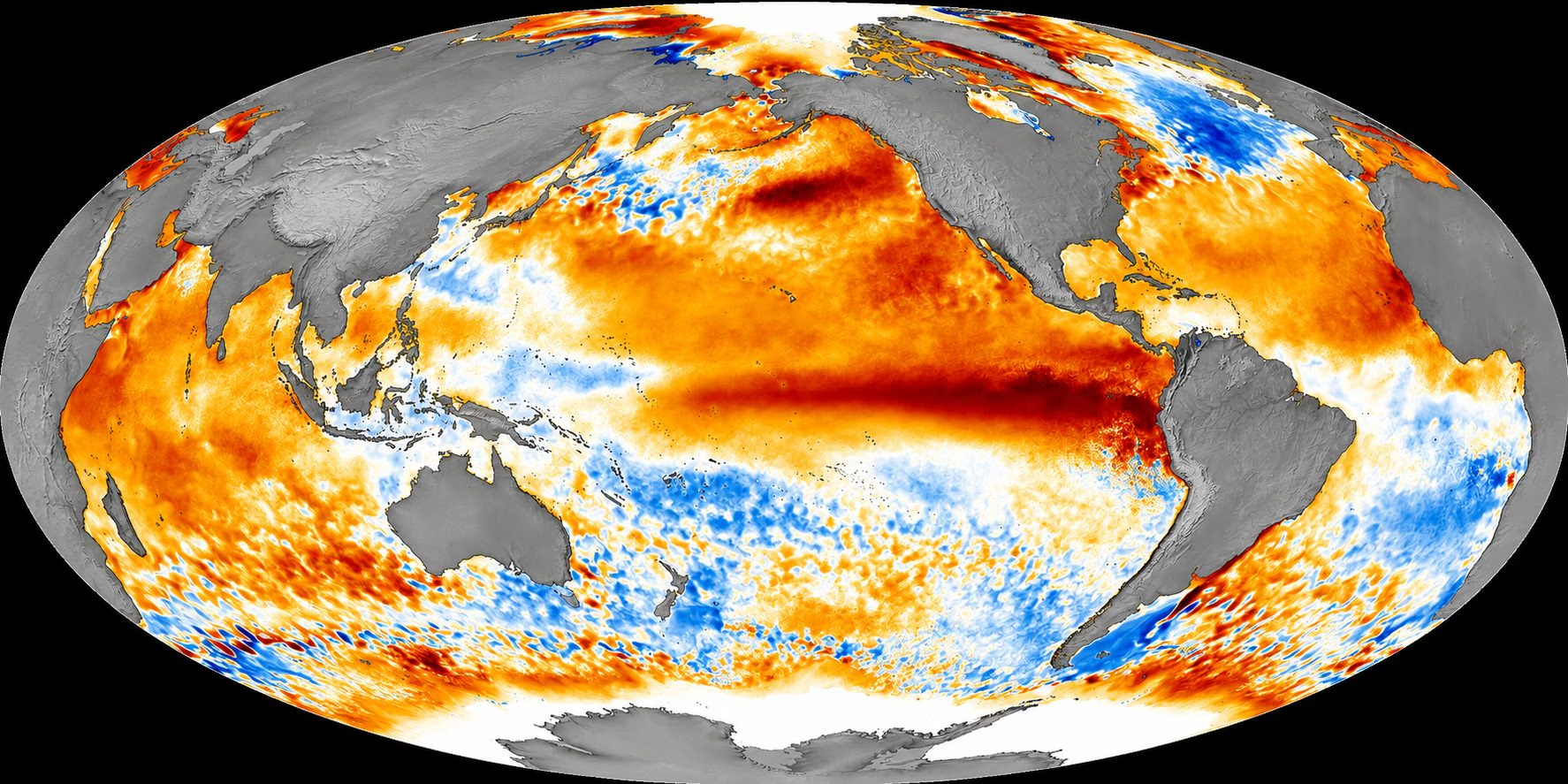
In recent months we have been talking insistently about El Niñodriven by official confirmations from the main international monitoring centers such as the NOAA (National Oceanic and Atmospheric Administration) and the European service Copernicus. Many headlines and articles appearing on the web paint scenarios already written for the winter of 2026-2027 in Europe and Italy, alternatively announcing “record heat until February” or “polar frost and snow on the plains”.
However, from the point of view of atmospheric physics and climatology, imposing mathematical certainties on the effects of El Niño in our country is a conceptual error. If for regions directly overlooking the Pacific or close to the equator (such as Peru, Ecuador, Indonesia and Australia) the consequences are often immediate and clearly defined, in Europe and the Mediterranean basin the situation is drastically different.
Why is there so much talk this year about a “Super El Niño”
To understand the origin of this media hype, it is necessary to define the nature of the phenomenon. El Niño it is the warm phase of the cyclical climatic oscillation known as ENSO (El Niño-Southern Oscillation). This is an anomalous and marked warming of the surface waters of the central and eastern equatorial Pacific Ocean, which alters global atmospheric circulation on a large scale.
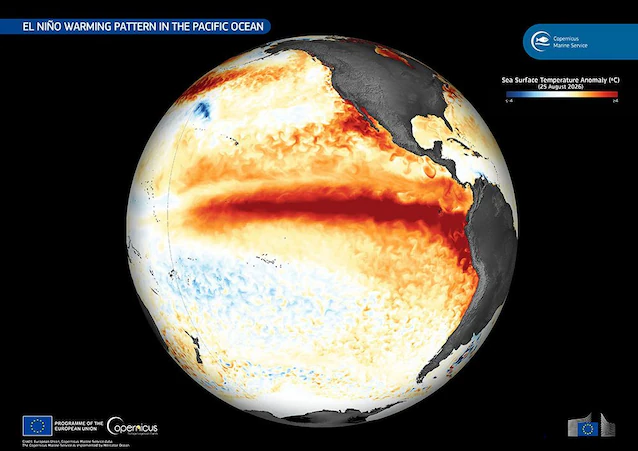
This year, media attention has skyrocketed as measurements have highlighted thermal anomalies in the water exceeding +1.5°C / +2.0°C compared to the average. When the parameters exceed these thresholds, the scientific community speaks of a “Super El Niño” (or Strong/Very Strong event), a historically rare category recorded only in a few previous cases, such as in 1997-1998 and 2015-2016. The exceptional amount of heat released by the ocean into the atmosphere has pushed many mass media to issue alarmist headlines, automatically projecting the local effects of the Pacific on a global level as if they were mathematical certainties for each individual country.
The distance from the Pacific Ocean and the weight of atmospheric teleconnections
While in the tropical and equatorial areas the consequences of El Niño follow linear and direct dynamics, with periods of severe drought in Indonesia and Australia and torrential rains on the coasts of the American Pacific, on the European continent the signal arrives attenuated and indirect.
In fact, Europe is thousands of kilometers away from the point of origin of the phenomenon. The influence of El Niño does not reach our country through direct currents of hot or cold air, but through the so-called atmospheric teleconnections: Extremely complex cause-and-effect chains propagating through the atmosphere on a planetary scale.
Unlike other continents, the weather in the Mediterranean basin and in Italy is dominated by a variety of regional factors and indices of atmospheric variability:
- The North Atlantic Oscillation (NAO) and the position of the Azores Anticyclone.
- The behavior of the Polar Vortex (both tropospheric and stratospheric).
- Temperature anomalies of the surface of the Mediterranean Sea (SST – Sea Surface Temperature).
- Anticyclonic blocks over northern Europe (like the Scandi Pattern).
These local variables act as real “disturbances” capable of amplifying, deviating or even completely cancel the footprint of El Niño on Italian territory. Global climatological analyzes clearly show how, in the face of certain and defined impacts in tropical areas, Europe always remains a neutral area without a single and obvious climatic trend.
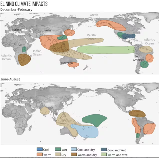
Certainties vs Probabilities: How El Niño Alters the Odds of Winter 2026-2027
The fact that there are no certainties does not mean that El Niño plays no role. In climatology we actually talk about modification of the probability distribution.
The phenomenon releases an immense amount of latent heat and humidity into the atmosphere, which globally tends to raise overall thermal averages. This excess heat interacts with large planetary waves (the Rossby Waves) that rise towards high latitudes, interfering with the stability of the Polar Vortex.
What are the possible scenarios for Italy based on historical data?
Looking at the historical series and the processing of long-term seasonal models (such as those of the European ECMWF centre):
- Late autumn and early winter (November – December): during the peak phase of El Niño, the circulation over the western Mediterranean tends to show a greater frequency of rainy phases. The entry of humid Atlantic currents onto a still very warm Mediterranean increases the probability of abundant rainfall, especially on the Tyrrhenian side and in the North-West regions.
- Heart and end of winter (January – March): the most frequent indirect signal linked to El Niño events comes through the potential weakening of the Polar Vortex (via sudden stratospheric warming or Sudden Stratospheric Warming). When the Polar Vortex weakens or breaks, the probability that blocks of high pressure will be created to the north (between Greenland and Scandinavia) increases, favoring the descent towards the Mediterranean of cold air masses of Arctic or Siberian origin.
The trend for Italy: what to expect based on current data
By analyzing current data and simulations from the main international computing centers for the cold season, the trend in Italy should not be read as a single monolithic block, but rather as a dynamic in two very distinct phases.
In the first part of the season, approximately between late autumn and the beginning of December, the most probable scenario, according to ECMWF analyses, sees the prevalence of Atlantic currents and Mediterranean humid flows. In this context, temperatures in Italy should remain on average in line with or slightly higher than the climatological norm, with a picture characterized by abundant and frequent rainfallespecially along the Tyrrhenian slopes and in the North-West regions. Impossible to go any further.
Considering El Niño as a “switch” that guarantees a priori a mild winter or, on the contrary, a winter of exceptional frost is scientifically incorrect. El Niño does not determine the daily weather in Italy, but it changes the probability picture.
