For the big landslide that hit Niscemi there isn’t one solution technically achievable to stabilize the territory. This is the result of a report produced by the University of Florence and presented to the Civil Protection, drawn up by a team of geologists coordinated by Nicola Casaglipresident of the OGS (National Institute of Oceanography and Experimental Geophysics) and expert in geological risks, ground instability, remote sensing and geological-technical modeling. While a new landslide hit the Niscemi area adjacent to the MOVE (Mobile user objective system) – an American system for satellite communications – we asked Casagli to explain the technical issues related to the report just presented and the risk management in the area of the landslide which occurred on January 25th, which caused around 2 billion euros in damage.
What are the most relevant elements that emerged from the report?
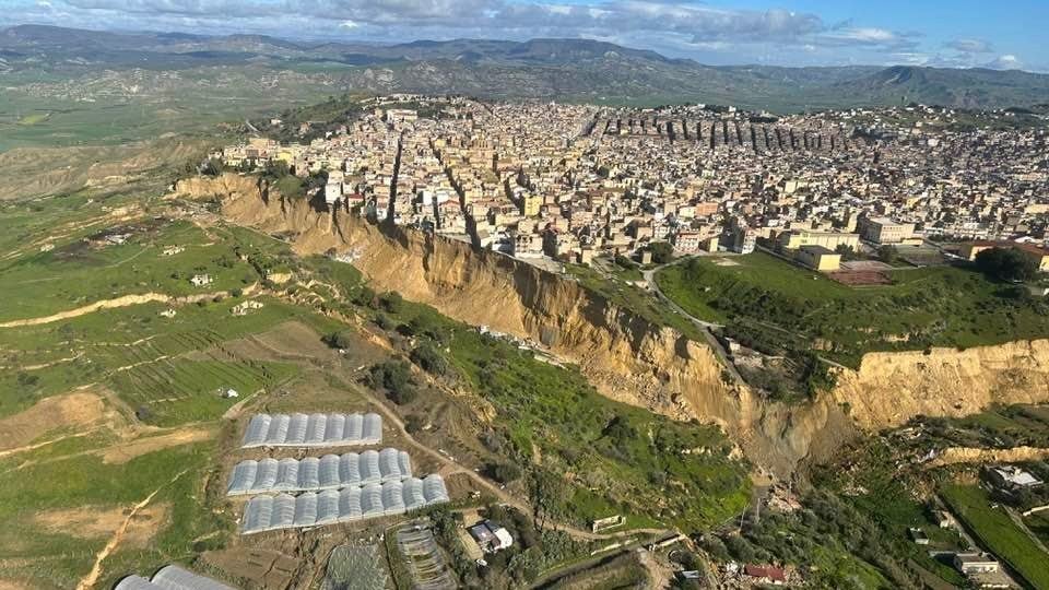
In terms of inspections and field surveys, the decisive fact is that it is not a single newly formed landslide, but the reactivation with areal expansion of a deep, historical and polycyclic landslide system. The high resolution topographic surveys and observations on the ground have made it possible to distinguish three main coalescing bodies – northern, central and southern landslide – with different kinematic mechanisms, for a total front of approximately 4.7km. The central landslide is the dominant sector, with displacements of approximately 50 massumed depth up to 80 m and clear retrogressive trend towards the inhabited centre.
In terms of satellite data, the report shows a very important result: before the event the inhabited center was substantially stable overall, while the slopes downstream already showed slow and persistent signs of deformation, at least since 2011. After the 2026 landslide event, interferometric and optical monitoring indicates a generally stable situation in the urban control zone, so much so that the model of retreat of the escarpment has allowed us to prudently remodulate the exclusion zone from 150 to 100 m in the central landslide sector. This does not mean absence of risk, but that the immediate risk in the town center is today linked above all to the retreat of the new escarpment.
Historical reconstruction has made it possible to demonstrate that the 2026 event it is not an isolated incidentbut rather consists of a new phase of a system active at least since the 18th century, with major precedents in 1790 and 1997. The spatial overlap between the bodies of 2026 and the historical ones, together with the coherence of the trigger mechanisms, reinforces the idea that the Niscemi slope has a long geomorphological memorycontrolled by lithology, hydrogeology, torrential erosion and tectonic structures. In other words, in Niscemi landslides are not the exception: they are a recurrent way of evolution of the slope.
What are the peculiarities of this event in the Italian and international context?
As for exceptionality in the Italian context, my reading is this: the event is exceptional in terms of size, complexity and proximity to the town centre, but is not anomalous from a typological point of view. In Italy there are large deep retrogressive and polycyclic landslides, even of comparable size and with a similar movement mechanism (compound sliding). However, a system with over 80 million cubic meters mobilized, depths of up to 80 m, a front of approximately 4.7 km and very high mobility, expressed by a propagation angle of 6.5°, it is certainly a case of importance also at an international level. Its exceptionality lies above all in the combination of large volume, high mobility, division into multiple coalescent sectors and direct interference with an important built-up area.
Which evolutionary scenarios do you consider most plausible for the Niscemi side?
The evolutionary scenarios considered most plausible today by the report are essentially two.
The first, considered the most probable in the short term, is theprogressive retreat of the newly formed slope. This is a partly natural and difficult to avoid process, through which the slope tends towards a new balance. This is the scenario that justifies the prohibition zone and the priority attention to safeguarding public safety.
What is your overall assessment of the future management of the Niscemi territory?
My overall assessment, as a landslide expert based on the data collected so far, is the following: in Niscemi we must not pursue the idea of ”definitively securing” the entire slope, because global stabilization through extensive structural interventions is not technically achievable. The scale of the phenomenon, the depth of the sliding surfaces, the sand-clay contrast, the role of erosion at the foot and the structural control make a single solution unrealistic. Future management must therefore be based on four principles:
- controlled coexistence with the landslide, not denial of the phenomenon;
- continuous and integrated monitoringwith geomorphological surveys, satellite data and on-site instrumentation;
- rigorous water controlwhich is the real technical issue: sewerage networks, urban drainage, collection of water emergencies, reduction of infiltration, protection from erosion of the Benefizio stream and the watersheds;
- selective territorial planningwith strong limitations on building in the most exposed areas and progressive relocation of the elements at greatest risk.
In summary, in the Niscemi area, instability cannot be eliminated, but it can be managed within acceptable levels of risk with an adaptive, multi-year and scientifically updated approach.