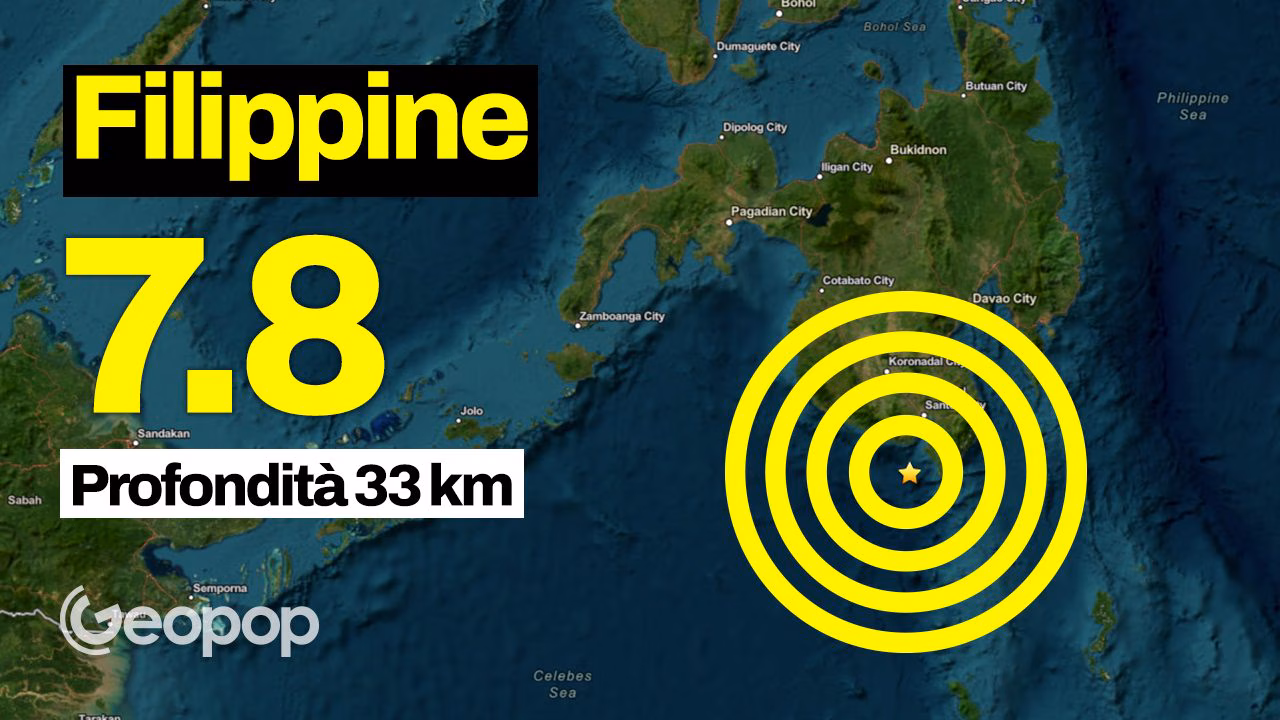
A violent one earthquake of magnitude 7.8 hit the Southern Philippines at 07:37 in the morning (local time, 01:37 in Italy) on Monday 8 June 2026, as confirmed by the USGS. The Philippine Institute of Volcanology and Seismology (PHIVOLCS) had initially recorded the earthquake at magnitude 7.0, then updated the estimate to 7.8.
The epicenter was located at sea, about 26 kilometers southwest of the coast of Kablalanin the province of Sarangani (island of Mindanao), with hypocenter at a depth of approximately 33km.
The shock, unfortunately, caused numerous damagesas also visible in post X below, with the current balance of victims which has recently risen to 15while i injured they would be more than 130: General Santos, a southern port with more than 700,000 inhabitants and an important hub for the tuna industry and trade, was among the hardest hit areas. A video released on official social channels showed a three-story building which housed a restaurant collapsed in a cloud of dust and debris, causing panic among passers-by.
According to the Philippine Institute, more were recorded following the 7.8 magnitude earthquake 138 aftershocksOf magnitude included between 1.3 and 6.7.
More pictures showed extensive damage to buildingswith shattered glass and collapsed roofs. Meanwhile, General Santos International Airport has temporarily suspended operations. Classes at all public and private schools in Cotabato City were suspended following the quake, while patients at the Kidapawan City hospital were temporarily evacuated to an open area.
Immediately after the first shock, the Pacific Tsunami Warning Center he issued a tsunami warningsignaling the possibility of waves up to 3 meters along some coasts of the Philippines and up at 1 meter on the coasts of Indonesia and of Malaysia. The director of PHIVOLS, Teresimo Bacolcol, confirmed that coastal monitoring stations had detected it waves of about 1 meter in the provinces of Sultan Kudarat and Sarangani. Anomalous waves have been detected in at least nine locations in the country, with amaximum height of 75 centimetres recorded on Sangihe Island.
The tsunami warning was withdrawn about five hours after the 7.37am quake, but the warning center urged the population to remain in a state of vigilance. Some warnings for possible tsunamis had also been issued for Japan (including Okinawa and the southern coast), for Taiwan and for the Papua New Guineaas well as for several islands and territories in the Western Pacific.
From a geological point of view, the frequency of earthquakes in the Philippines is due to their location on the Pacific Ring of Firewhich represents the area with the highest concentration of active volcanoes and earthquakes on the planet. According to what was reported by PHIVOLCS, based on the location of the earthquake and the distribution of aftershocks, the earthquake may have been caused by the subduction process (the phenomenon whereby two plates collide and the denser one tends to “slide” under the other) along the Cotabato Trench.