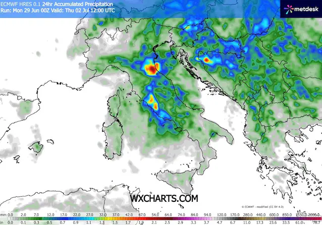
The gigantic one heat bubble extreme that has literally trapped Italy in recent weeks is about to suffer its first real shock. In the next few hours we will see a progression failure of high pressure: a change which, although awaited by those who can no longer stand the heat, brings with it a load of thermal energy ready to explode. A slight drop in pressure at altitude expected between Monday 29th and Tuesday 30th in fact, it will be enough to break the delicate atmospheric balance, triggering intense storms that will initially hit the Alps and Pre-Alpsand then pour on Po Valleywith an expected worsening between Wednesday 1st and the morning of Thursday 2nd due to the entry of cooler air. Subsequently, between Thursday 2nd and Friday 3rdthis instability will slide towards the regions of Central-Southalso bringing showers and thunderstorms to these sectors. The areas most affected could be the Triveneto, Emilia-Romagna, Lazio and Campania.
Predict theexact trajectory of these phenomena is one of the most difficult challenges for supercomputers and mathematical models. The reason is purely physical: there is so much heat accumulated in the atmosphere that thunderstorms can form suddenly wherever the slightest draft is created, especially in the absence of a real front that follows a certain direction. In this scenario, the Mediterranean Sea plays a crucial and at the same time worrying role. With record surface temperatures that have touched the 29°Cour sea has stopped doing its classic job of climate mitigation and has turned into fuel for bad weather.
Because we risk hailstorms and winds over 100 km/h
The real danger of this weather transition is linked to severity of convective phenomenaor the vertical motions of the air. When the incoming cool air collides with the pre-existing warm and humid layer on the ground, the hot air will literally be thrown upwards at crazy speeds. It is the perfect recipe for the birth of supercellsthe most dangerous storms of all, capable of generating hailstorms with large stones.
Together with hail, maximum attention must be paid to the phenomenon of downburst. Often confused with a tornado, a downburst is a column of cold air that descends perpendicularly from the storm and violently impacts the ground, then expanding horizontally in all directions. This creates linear wind gusts that can exceed 100 km/huprooting trees and tearing off roofs with a violence similar to that of a tornado.
The illusion of freshness and the “radiator” effect of the Mediterranean
If you think that after this phase the summer will return to being the mild one it once was, unfortunately the news is not the best. The thermal damage is now done. With such a boiling sea and a superheated atmosphere up to high altitudes, theThermal inertia of the system is enormous and it is unfortunately utopian to hope for a lasting drop in temperatures. The refreshment and partial temperature drop of the next few days will be a temporary reliefamplified simply by the fact that we come from an anomalous meteorological period.
The truce, in fact, will be short and promises to be a simple parenthesis. Medium-term projections indicate that this unstable passage will not leave deep traces: as early as next weekend the large subtropical anticyclone could return to influence our peninsula, restoring conditions of stability and once again blocking Italy in the grip of the great heat.