
Summer 2026 doesn’t seem willing to give way easily. After a quarter characterized by temperatures constantly above of the seasonal averages and by as many as five widespread heat waves, today, Tuesday 1st Septembermeteorological autumn begins. To understand what awaits us in the next month, the projections of the mathematical model of European Center for Medium-Term Weather Forecasts (ECMWF) paint a clear picture: a broken September two opposite phases.
Between the 3 and September 7 Italy will in fact have to deal with the sixth heat wave of the season. Starting from September 13thinstead, the real seasonal break should take place, with the entry into the Mediterranean of colder currents. A heavy meteorological pattern, made even more anomalous by the accumulation of heat and steam which has transformed the Mediterranean basin into a real thermal reservoir.
What the weather will be like in the first half of September: anticyclone and record temperatures
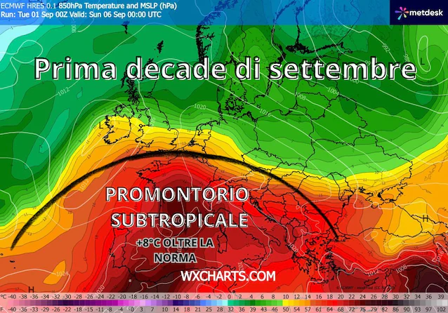
The first ten days of the month will see the constant presence of promontory subtropicalcapable of guaranteeing atmospheric stability and pushing air masses of Saharan origin towards our Peninsula, with temperatures up to +20/23°C at the reference altitude of 1500 meters over Spain, France, Switzerland and Italy.
The surface temperature of the African also intervenes to amplify this African blaze Mediterranean Seaexceptionally hot after the summer months. In several basins around Italy surface waters record up to 5°C above averagea factor that prevents night-time cooling and keeps thermal values high even along the coasts and in the internal plains.
The areas most affected by the heat in Italy
- Central-South and Major Islands: expected values widely between i 35°C and 37°Cwith even higher local peaks in the internal areas of the Sicilyfrom the Sardinia and of Puglia.
- Northern Italy: the heat will also be felt markedly in the northern plains, with highs up to 35-36°C especially among Eastern Lombardy, lower Veneto and Emilia-Romagna. TO Milan the models signal the concrete possibility of retouching or exceeding the historical heat records for the month of September.
The possible turning point from September 10-14: colder currents
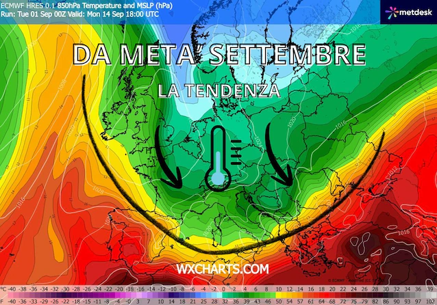
However, ECMWF trends point to the arrival of a potential turning point. The first signs of a loosening of the hot socket will be felt immediately after the 9-10 Septemberwhen cooler currents of origin Atlantic they will begin to undermine the anticyclone starting from the northern regions.
The real one seasonal break however, it could materialize approximately between 13 and 14 September. The weakening of the African bubble will allow the colder northern currents to lower in latitude, sinking towards the Mediterranean basin.
The “bill to pay” of the summer: how long will the thermal legacy on the autumn climate last
For the return of the cool, we will first have to deal with the legacy left by it prolonged climatic anomaly. The consequences of three summer months constantly above the norm will not disappear overnight, but they risk influencing the trend of the entire autumn. In practical terms, this accumulation will result in the persistence of ground temperatures above average and in an increased risk of extreme weather phenomena.
The entry of the first Atlantic pockets after an exceptionally hot season could cause extreme weather events. The arrival of cold currents at high altitude will impact directly against the warm, humid air reservoir stationary over the Mediterranean basin. This marked thermal contrast will generate a massive amount of CAPE (Convective Available Potential Energy), or the floating potential energy that fuels the upward motions of the clouds. The greater the energy accumulated in the lower layers, more violent and explosive they risk being the thunderstorms, when the anticyclonic structure finally gives way.
This dynamic will significantly increase the risk of extreme weather phenomena:
- Trigger of intense storm lines and supercells.
- Possibility of self-healing storms and cloudbursts concentrated in short periods of time.
- Occasional risk large hailstorms and strong gusts of wind (downburst).
Since these are medium and long term projections, it will be fundamental follow the next updates to precisely define the trajectory of the disturbances. The general framework outlined by ECMWF however suggests a September with two faces: a very warm start, followed by a second half that is decidedly more unstable, dynamic and with an autumnal flavour.
