From a purely geological point of view, the Tyrrhenian Sea could be defined not as a sea, and in particular a portion of the Mediterranean Sea, but a ocean. This is because it is expandinga typical characteristic of the oceans: over time, in fact, magma has escaped from its seabed, giving rise to new oceanic crust. Indeed, approximately 2 million years agoits expansion speed reached i 20 cm/yearexceeding that of all other oceans. The numerous underwater volcanoes which are found on its seabed, including the Marsili (the largest in Europe at 3000 m high), and the so-called “magnetic anomalies” of the ocean floor testify to this process.
The opening of the Tyrrhenian Sea
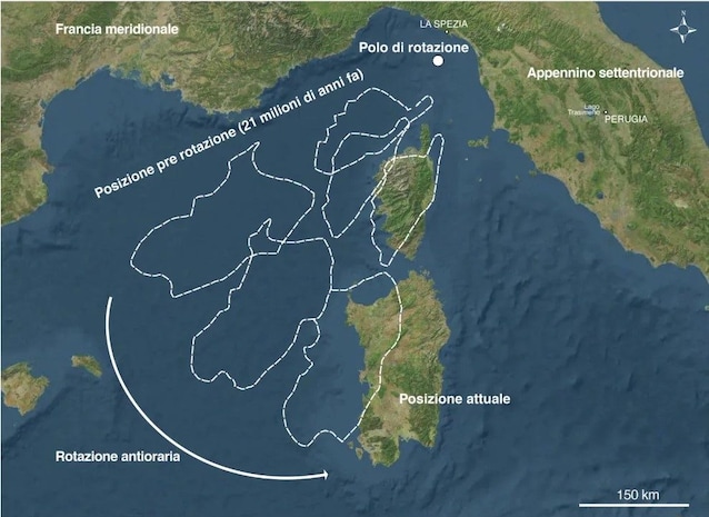
Until 10 million years agothe Tyrrhenian Sea did not exist. It was the collision between lithospheric plates, particularly between that one European and that Africanto determine its opening. The movements of these plates, in fact, brought about a block of earth’s crust which included present-day Corsica and Sardinia (Sardinian-Corsican block) to detach by rotating counterclockwise towards the south-east. This movement determined a movement towards the east of the Apennine chain that was forming, faster than that of the Sardinian-Corsican block. Due to this difference in speed, between the Sardinian-Corsican block and the mountain range the Tyrrhenian Sea openedwhich was initially very narrow and which over time became increasingly wider. An important consequence of the opening of the Tyrrhenian Sea was the closure of the Strait of Gibraltar, with theisolation of the Mediterranean from the Atlantic Ocean, which approx 6 million years ago led him to dry up by evaporation.
The Tyrrhenian Sea becomes an expanding ocean
The relaxing forces caused the opening of the seabed of the Tyrrhenian Sea deep fracturesfrom which they emerged large volumes of magma coming from the underlying mantle. This is what happens at the ocean ridges that cross the oceans, where the relaxing efforts cause two adjacent lithospheric plates to move apart. The magma that comes out of the ridge solidifies forming new crust basalticwhich pushes the old one sideways: this mechanism determines theexpansion of the ocean floor. In some places the rising magma gave rise to the numerous underwater volcanoes that rise on the seabed of the Tyrrhenian Sea: the famous Marsiliwhich rises 3000 m from the seabed and with a diameter of over 50 km, but also others including Palinuro, Vavilov, Sisifo and Glauco.

The speed of expansion of the Tyrrhenian Sea
The Tyrrhenian Sea not only expanded like an ocean, but in the past it did so at an astonishing speed, faster than all other oceans. In 2006 the INGV (National Institute of Geophysics and Volcanology) discovered that between 1.5 and 2 million years ago the Tyrrhenian Sea has reached an expansion speed equal to 20 cm/year (that of the Pacific Ocean is 15 cm/year). This record was achieved approximately where Marsili is located, on an abyssal plain about 3500 m deep below sea level. Over time, there have been periods in which expansion slowed down and others in which it accelerated. But how do we know these details?
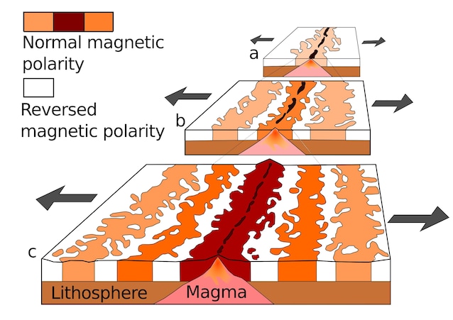
Magnetic anomalies allow us to calculate the expansion speed
The speed of expansion was determined thanks to the so-called “magnetic anomalies” of the ocean floor, which in the case of the Tyrrhenian Sea reaches a depth of 3800 metres. The magma that comes out of an oceanic ridge, in fact, solidifies on both its sides, forming new basaltic crust. Your ferromagnetic minerals they take on theorientation of the Earth’s magnetic field present at the moment of solidification. The Earth’s magnetic field, in fact, periodically reverses its orientation (the magnetic North pole takes the place of the magnetic South pole and vice versa). The result is that parallel and symmetrical bands of rocks form on the sides of the ridge whose minerals have an orientation equal to that of the current magnetic field (with normal polarity), alternating with bands in which the orientation is opposite (with reverse polarity). These bands testify to the expansion of the ocean floor and have allowed calculate their age correlating the anomalies with the time scale of the reversals of the Earth’s magnetic field (reconstructed by studying lava sequences on land). Starting from the age of the rocks and their distance from the ridge it was possible calculate the expansion rate of the oceans.