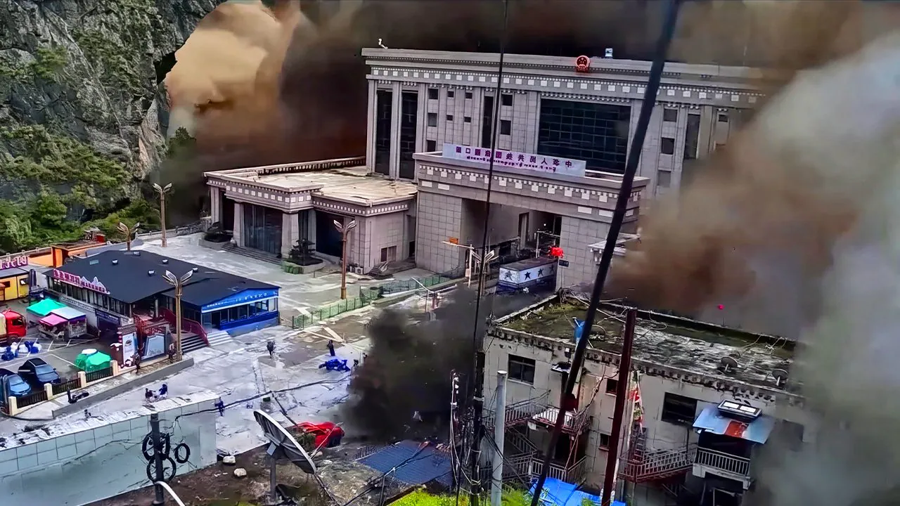
A flash flood hit the Rasuwa districton the border between Northern Nepal and Tibet: according to reconstructions, the flood wave of August 26th reached a speed of approximately 180 km/has if it were a huge “bucket of mud”. The death toll, unfortunately, is dramatic: we are talking about more 1,000 dead and almost 4,000 missingincluding 3 Italian citizens, but the data is still provisional. Meanwhile, the rescue services are working tirelessly to try to free him more than 600 workersremained trapped in the tunnels of some hydroelectric plants, with the exits blocked by mud and debris.
Faced with such devastating images, the question many have asked is only one: how does a river of mud arrive all at once, almost instantly? The short answer is that for the arrival downstream to have been so sudden, it must have released itself just as suddenly upstream a huge amount of water. Not a progressive release, but a one-shot.
And it’s exactly onorigin of that water that the work of the scientific community is concentrating in recent days on reconstructing the causes of the disaster.
No earthquake: the 600m portion of the glacier gave way
The starting point is one portion of the Langtang Lirung glacierthe mountain that with its 7,234 meters it dominates the valley of the same name, known not by chance as the “Valley of the Glaciers”. The material precipitated into the river Lhende Kholaon the border between the Nepalese district of Rasuwa and Tibet, and then spread along the Bhote Koshi-Trishuli river system, with effects recorded on over 100 kilometers of waterways.
The first satellite analyzes show a portion of glacier approximately 600 meters wide detached from an altitude of 5,100 metres: the geoscientist Jacob Steinerof the University of Graz, explains that the lower part of the glacial tongue broke away because the underlying rock he gave in. The glacier, in fact, lost its support and fell to around 3,000 meters above sea level.
Dan Shugarfrom the University of Calgary, adds an important detail by observing the most recent images: not only ice broke off, but also a substantial portion of rock of the slope itself, a real rock collapse that dragged the glacier with it. The geomorphologist Kristen Cookfrom the Grenoble Alpes University, talks about hundreds of millions of tons of materialbased on the first analyzes of the seismic signal.
Regarding the seismic signal, in the first hours following the disaster, news of a earthquake of magnitude 4.4which occurred at 08:37 local time, indicated as a possible trigger for the collapse. The USGS, the US Geological Survey, then corrected this interpretation: by analyzing long-period seismic waves, it established that that signal was not of tectonic origin, but generated by the collapse itselfwith an energy equivalent to a magnitude 5.2 earthquake. In other words, the earthquake didn’t cause the landslide: it was the landslide that produced a signal that sounded like an earthquake.
Where did all that water come from: the three possible scenarios
The fact that a portion of the Langtang Lirung glacier collapsed is therefore a consolidated fact according to the latest analyses. The disastrous downstream effects can instead be explained by looking at the morphology of the territory. The material was funneled in narrow and incised valleyswith very steep slopes: a configuration that concentrates the energy of the flow instead of dispersing it and which amplifies both its speed and level.
This is why the images show bridges being carried away as if they were made of paper, trucks being moved like toys, buildings being uprooted from their foundations. From a mechanical point of view, what was seen descending was not water: it was a dense and heavy mass, more like concrete freshly poured down a gorge rather than a raging river. Along the path of this flow, for kilometres, there were inhabited centers and infrastructures: hence the very high number of victims.
Now, however, the real open question is another: where the volume of water came from necessary to produce such a devastating flood wave. They are currently discussing this three scenarios.
First scenario: the GLOF
The first hypothesis taken into consideration was that of a GLOF, Glacial Lake Outburst Floodthat is, it sudden emptying of a glacial lakeoften held back by banks of ice or moraine debris, fragile by nature. It is the most intuitive hypothesis because it had already happenedon the same river: on 8 July 2025, the Department of Hydrology and Meteorology of Nepal attributed a similar flood to the emptying of a supraglacial lake in Tibet, about 30 kilometers upstream, with nine victims.
To date, however, satellite images they do not show the typical scars of a lake that has emptied. It is not a definitively ruled out scenario, but it is a scenario for which, at the moment, there is a lack of evidence.
Second scenario: no lake, three different springs
If the lake is not there, the water must have come from elsewhere. The hypothesis proposed by Dave Petley, among the world’s leading landslide experts, is that the volume derives from sum of three distinct contributions: the melted ice from the energy released by the impact and friction during the fall, the water already contained in the sediments of the valley floor, already saturated due to the current monsoon season, and finally the water of the stream itself, incorporated along the way.
Taken individually, Petley himself explains, these three sources would struggle to justify a similar volume. Added up, maybe yes. But it is, admittedly, a hypothesisnot a conclusion.
Third scenario: the landslide that blocks the river
The third scenario, and it is the one also publicly supported by Jacob Steineris that the collapsed material have blocked temporarily the course of the river Lhende Khola, forming one natural dam. Water would have accumulated behind this dam until it did give inreleasing all the accumulated volume in one fell swoop. It is a mechanism frequently observed in the Himalayan environment, and it is being observed again in these days, with two new barrier lakes formed further upstream after the event.
However, there is a problem times which is worth telling, because it is the type of verification on which the scientific method is based. Assuming the time of the seismic signal as the start of the phenomenon, 08:37, the surveillance cameras at the Gyirong crossing recorded the arrival of the wave about 7 minutes later. In that interval the flow would have passed through the first ones 22 kilometers at an average speed close to i 200 km/h.
A flow that never seems to have stopped. And if it hasn’t stopped, it stays little time to accumulate and then release an entire barrier lake: for comparison, the barrier lake formed after the event, further upstream, took two full days to give way. This does not deny the barrier scenario, which may have been short or partial, but it opens up a question that research will have to address in detail in the coming weeks.
The bigger picture: Glaciers are melting everywhere
This event, however, is not an isolated episode: it is part of a global, documented and accelerating trend. A 2023 UN report had already reported that the Nepal ha lost a third of its ice volume over the last thirty years, with a melting rate of 65% faster in the last decade compared to the previous one. Globally, only in 2025 the glaciers of the planet (excluding the continental systems of Greenland and Antarctica) have lost approx 408 billion tons of icewith a margin of uncertainty of approximately 132 billion.
It must be said with caution that these events require: connect in a direct and unambiguous way single episode to climate change Not is never correct from a scientific point of view, as she underlines Kristen Cook. What is documented, however, is the general picture: the planet is in an interglacial, i.e. warm, phase, which began around 18,000 years ago, and in the last 150 years anthropic action has amplified this natural tendency abruptly.
Dan Shugar he says it clearly: it is 100% certain that climate change will make events like this more frequent, due to the combination of glacial melting, permafrost thawing and alteration of precipitation and temperature regimes.
What can we really do in the future
The more concrete question remains. Faced with phenomena of this violence, what can be done to reduce the damage and the number of victims? Reinforcing buildings is not enough. There is no house, no matter how solid, capable of withstanding the impact of a debris flow of this size: it is not a problem comparable to the seismic one, where building in an anti-seismic way concretely reduces the risk.
Here the decisive variable is not the resistance of the building, it is its position. The most effective measure, however uncomfortable to accept, is not to be inside the riverbed or close to the glacial torrents when these phenomena occur. It applies to the Himalayas, but it’s worth it the same way for the Alps and for any other mountain range with retreating glaciers: as these events become more frequent, the relocation of settlements from the most exposed areas, together with early warning systems capable of gaining even just a few minutes, will remain the most realistic tool for saving human lives.
