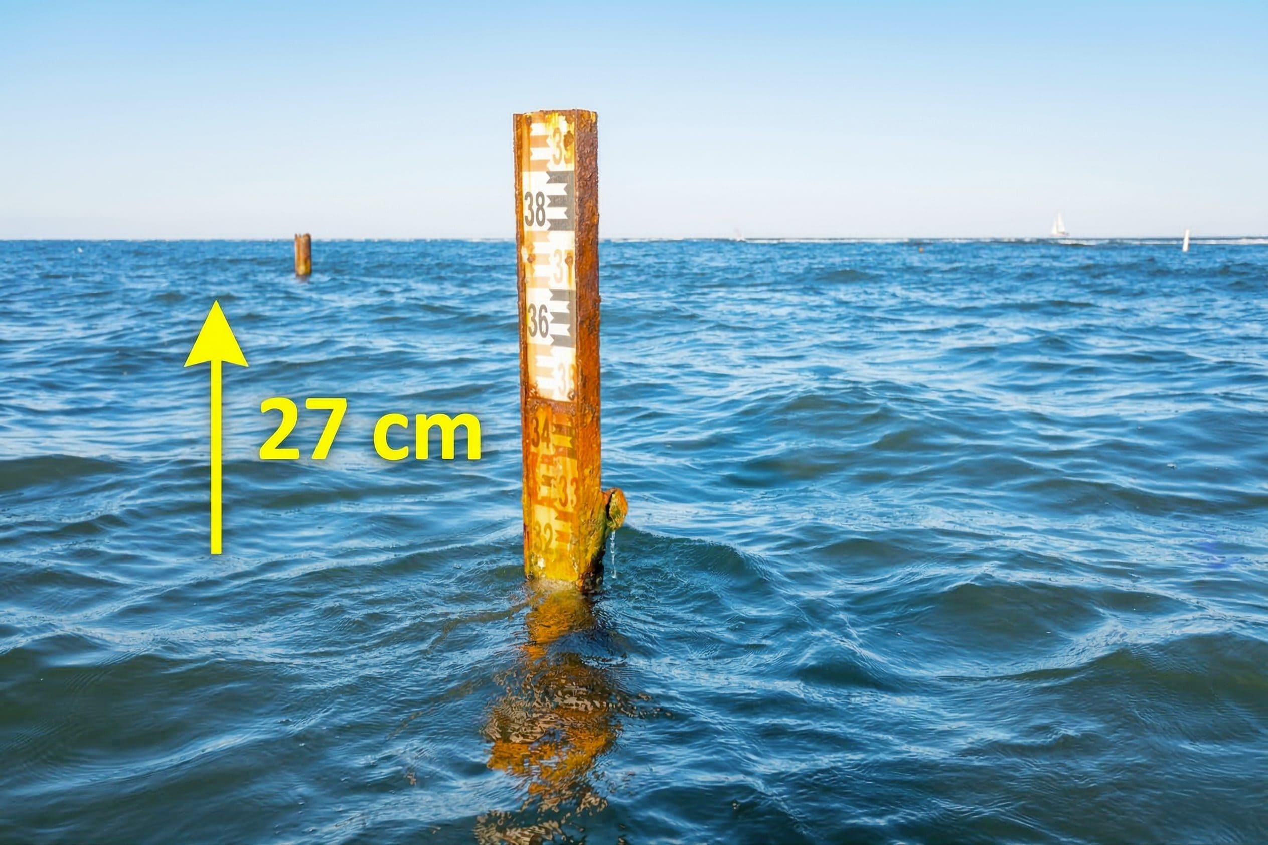
Sea levels on many coasts of the world are higher than reported in many scientific studies, with an average discrepancy of 27 centimetres which in some areas of the world even exceeds 1 meter. This is what a meta-analysis conducted by Katarina Seeger And Philip Minderhoud of the University of Padua showed a methodological flaw in almost all published research on the topic: of 385 studies published between 2009 and 2025, at least 90% establish sea level based on theoretical models of the shape of the sea geoid terrestrial instead of real measurements on the coasts, which however turned out to be a non-negligible underestimate. This discovery involves a review of the models on which coastal risks are assessed.
Because the real sea level is higher than the theoretical one
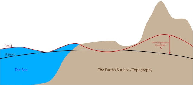
When we have to establish where the sea level is, it makes sense to refer to the mathematical model of the shape of the Earth, i.e. the geoid. This is calculated from a myriad of satellite data and establishes the equipotential surface of the Earth, that is, the one that is perpendicular to the plumb line point by point.

Ideally, sea level follows the surface of the geoid, as the image below shows.
However, phenomena locally affect the real sea level. Beyond phenomena such as currents, temperature, salinity, interaction with ice and so on, there is a phenomenon that has the effect of increasing sea levels almost everywhere: the global warming. In fact, our climate-changing emissions do not only warm the air: on the contrary, almost all the excess heat due to climate change is absorbed by the oceans, which have a very high thermal capacity. But everything that warms expands, and oceans are no exception: global warming increases their volume, consequently raising global sea levels.
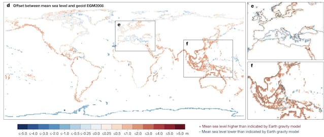
The cumulative effect of all these phenomena measured by the new study is an average discrepancy of +27 centimeters across all world coasts. This discrepancy increases significantly in the global Southwhere the satellite data for calculating the geoid is decidedly less and therefore the measurement of the geoid is more imprecise. In South America and South-East Asia, real levels are even 1 meter higher than those estimated in the scientific literature.
What changes in concrete terms? The implications of the new study for coastal risk
Until now we have always taken it for granted that all these local and global phenomena together had a small enough effect to make the geoid an excellent approximation of sea level. And in fact it cannot be said that it is not: after all we are talking about an average discrepancy of 27 centimetres. But in a context of rapid sea level rise, when we talk about coastal risk a few tens of centimeters make the difference. The authors estimated that, using real sea level, the land likely to fall below sea level by 2100 increases by 31-37% and the related population of 48-68% (we talk until 132 million people plus at risk of living in an area that could be invaded by the sea).
The fact is that seas are rising rapidly in many parts of the world. Globally, over the last decade the average is +4.6 millimeters per yearand is increasing compared to the previous decade. For those who live in coastal areas, rising sea levels are as if it were the countdown in an action film: the higher the level rises, the greater the coastal risk, until at a certain point a given territory will find itself below sea level, with all that that entails. The risk is particularly serious in coastal areas with aquifers: the more the sea grows, the more it sneaks into the aquifers, making their water salty, with imaginable consequences for the population’s water supply, agriculture and livestock farming. This new study is essentially telling us that the countdown is getting shorter in many parts of the world.
Not in all, however: we know for example that in Greenland the sea level is lowering, because the melting of the ice (again due to global warming) makes the Arctic island literally lighter and therefore makes it “sink” less into the Earth’s mantle. The analysis published on Nature reveals that also the Mediterranean is bucking the trend: the real sea level is lower than that estimated from the terrestrial geoid.
This does not mean that we in Italy can sleep peacefully: the problem is global and affects us too. The countdown may have gotten a little longer here, but it’s still continuing to tick.