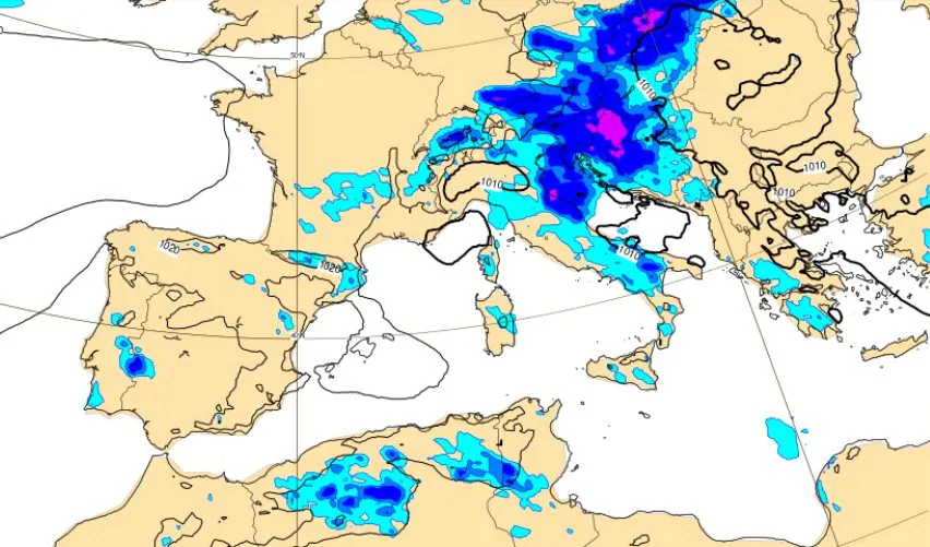
The intense heat wave that is dominating the meteorological scenario on our peninsula is preparing to undergo an initial and temporary reduction after August 15th. During the weekend, warm temperatures and mostly sunny weather will prevail. A ripple of cooler currents descending from Northern Europe, however, it is approaching the Mediterranean, where it will trigger a phase of marked instability starting from the beginning of next week. A change announced a few days ago: however, the latest updates provided by the mathematical models have brought about a change substantial modification to the original trajectory of this unstable impulse, reducing the extent of the worsening in different regions and concentrating the most intense phenomena mainly along the Adriatic side and the eastern areas of the country.
Mid-August still hot with temperatures above 38°C, but the red marks drop
Before witnessing the turning point at the beginning of the week, the day, but in general the Ferragosto weekend will pass under the sign of a still scorching climate in much of the country. Thermometers will reach extreme peaks especially in the internal areas of the Center and the Po Valley: Florence confirms itself as the hottest city in Italy with 39°C expected, followed closely at altitude 38°C from Prato, Pistoia and Terni. Intense heat also in Lucca, Parma, Pisa, Reggio Emilia, Piacenza and Benevento, all stable on 37°C.
On the health alert front, the map of the Ministry of Health shows a general reduction in the alarm levels, which we remember is not based only on the temperature but on a mix of factors, for example the humidity rate: for the day of 15 August, in fact, they will be only Bari and Bolzano maintain the red label due to the risk of heat waves, while most of the remaining cities will be placed on the yellow label. A clear sign of how the atmosphere is gradually starting to change before the stormy break arrives.
Thunderstorms and atmospheric changes expected between Sunday 16th and Tuesday 18th
The first signs of this atmospheric change will appear already in the course of Sunday 16 Augustwhen the vanguard of fresh air will begin to approach the Alps. The first thunderstorms will develop during the afternoon and evening hours, especially close to the reliefs of the Central-Northwith some local encroachment towards the adjacent flat areas, in a climatic context which will still remain decidedly hot and muggy.
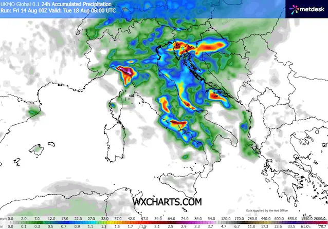
The acute phase of the storm passage will, however, be concentrated between the day of Monday 17 and the early hours of Tuesday 18. Compared to the projections of a few days ago, which hypothesized a more western thrust capable of fully involving the Tyrrhenian side as well, the new trajectory will see the fresh trough sliding along the eastern margin of the Peninsula. The fresh air will touch Italy moving from north to south and activating a rapid pass of showers and thunderstorms which will particularly affect the Triveneto and the Adriatic regionsfrom the Marche to Puglia. In these areas, the thermal contrast between the fresh air at altitude and the pre-existing hot mass may generate phenomena of strong intensity, accompanied by frequent hailstorms and sudden gusts of wind.
Thunderstorms and expected changes between implications for large cities and thermal decline
The effects in terms of rainfall will however be much more limited on the rest of the national territory. The large cities of the North-West, such as Milan and Turinwill see few phenomena or accumulations that are completely irrelevant compared to the provincial capitals of the Adriatic regions. Likewise, the capital and the Tyrrhenian side will also remain a little more on the margins but there is still a high probability of observing the rapid passage of rains and storms, in particular for Eastern Liguria, upper Tuscany, Lazio and Campania.
On the temperature front, however, the change in ventilation will be felt more widely. Over much of the country there will be a general thermal decline of between 4 and 5°Cwith peaks of decline up to 6-8°C along the Adriatic coast. Even in less rainy areas you will appreciate a decrease of approx 3 or 4°Cenough to provide a temporary breath of fresh air. However, it will not be a total collapse: the values will simply return to approaching the averages of the period, while remaining slightly above the climatological norm.
Midweek break and possible new disruption from August 21st
The unstable phase will however be rather fast. Already during the afternoon and evening of Tuesday 18 August there will be a rapid improvement starting from the north, with the departure of the storms towards the South and the simultaneous return of large sunny spells. The high pressure will in fact attempt a new and immediate rise towards the central Mediterranean basin, restoring conditions more stable and sunny weather.
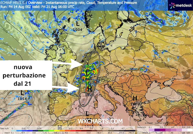
This respite may prove short-lived, however. The medium-term projections in fact show the entry of a second and more incisive wave cable in the second half of the week, approximately starting from Friday 21 August. This new Atlantic disturbance would seem to target the regions more directly Northern Italywhere a much more organized phase of bad weather could reopen with widespread rain and thunderstorms.
Why did the models scale back this “break” of the summer? And it’s not the first time.
This continuous change of scenario deserves a reflection on the forecasting dynamics. Until about four days ago, the main computer centers showed a worsening of a very different magnitude for this mid-August, outlining a real seasonal break capable of wiping out the African heat. As the event approached, however, the simulations progressively retracted the initial prediction, reducing the impact of the fresh entry.
The reason for this retraction lies in the immense amount of heat and humidity accumulated over the Mediterranean basin after months of anomalous temperatures. This warm layer works like a real thermal shield which offers great resistance to the penetration of cold Nordic currents. As a result, unstable ripples have a hard time sinking into the Mediterranean and tend to slide along its eastern margins. The transition from an extreme heat regime to a more unstable context therefore occurs with much more gradual than the models tend to estimate well in advance. Precisely for this reason it is essential to constantly consult updates close to weather events, always maintaining due caution in the face of long-term trends.
