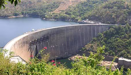
Harness 180 billion cubic meters of water on a surface of 5,500 km²: the filling of the Kariba Dam between 1958 and 1963, on the border between Zambia And Zimbabwenot only created the largest artificial reservoir on the planet by capacity, but accompanied approx 2,000 seismic shocksculminating in a strong earthquake of magnitude 6.1 on September 23, 1963, forcing geotechnical science to refine the rules of rock mechanics and the safety of large hydraulic works.
The Kariba hydroelectric plant
There dam Of Kariba is a huge hydraulic engineering work that was built in the Kariba gorge along the course of the Zambezi river, on the border between Zambia And Zimbabwe. Designed in the 1950s, the main structure consists of a double-curved reinforced concrete arch dam, characterized by a height of 128 meters and a crowning development of 579 meters.
The work was carried out in order to satisfy the large energy needs of the copper mining industry (in the Zambian Copperbelt region) and to support the industrial development of both neighboring countries. The hydroelectric complex uses two distinct underground power plants (the Kariba South Bank in Zimbabwe and the Kariba North Bank in Zambia), with a total installed power of around 2,000 MW.
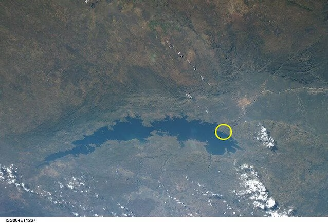
The artificial basin generated by the dam – Lake Kariba – has an extension of more than 1000 metres 280 kilometers in length and reaches a maximum width of 40 kilometersand is capable of retaining a mass of water capable of locally altering the geodetic topography and the distribution of crustal masses.
The phenomenon of induced seismicity
There reservoir-induced seismicity (known in science as Reservoir-Induced Seismicity or RES) is an established geotechnical and geophysical phenomenon in which the filling of a reservoir is capable of altering the natural stress of the earth’s crust, causing the reactivation of pre-existing faults. In the case of the Kariba Dam, the presence of an active extensional tectonic system attributable to the offshoots of the East African Rift constituted the ideal context for seismic triggering.
The reservoir acts according to two fundamental hydro-geomechanical mechanisms. First of all theAndimmediate hydrostatic load effect, in which the accumulation of 180 billion tons of water generates a sudden increase in the total normal stress and shear stress on the underlying fault planes. In an extensional tectonic regime, this increase increases the destabilizing component along the fault.
We also have a pore pressure diffusion effect. In fact, as time passes, water percolates through the microfractures of the rock matrix, gradually increasing the pore pressure at great depths (5–10 km). This increase directly reduces the effective normal stress, reducing the shear resistance of the fault to the point of causing sudden slippage of the blocks. At Kariba, the seismic sequence began in 1959 during the early stages of filling, culminating on the night of 23 and 24 September 1963 with a main earthquake of magnitude 6.1 – 6.2, followed by hundreds of aftershocks. The Kariba event is historically recognized as one of the classic cases and among the first large-magnitude induced earthquakes (RIS) studied in detail.
The economic impact of the engineering work
The economic impact of the Kariba Dam is articulated in a complex duality between the extraordinary push for regional development hey heavy maintenance costs emerged over the long term. Ever since the project was implemented, it has represented the primary driver of the industrialization of this area of the African continent, guaranteeing the continuous and low-cost electricity supply essential to power the flourishing copper mining industry in Zambia and the manufacturing and urban sector of Zimbabwe, covering approximately half of the latter’s electricity demand.
It should also be underlined, however, that this enormous competitive advantage has generated a dangerous dependence structural. The prolonged periods of drought that have unfortunately affected the Zambezi river basin in recent decades have drastically reduced the useful reservoir volumes, causing severe energy crises and prolonged industrial blackouts that have paralyzed entire production chains. Added to this are the enormous financial costs for geotechnical safety: to avoid a catastrophic structural failure, international institutions such as the World Bank, the European Union and the African Development Bank had to allocate approximately three hundred million dollars in order to finance complex restoration and stabilization works of the dissipation pit and the arch of the dam. The systemic risk of a possible collapse, which would also overwhelm the Cahora Bassa infrastructure further downstream in Mozambique, thus transforms the financial management of the work into a permanent budgetary challenge for the entire region.
Environmental impact
The creation of the Kariba Basin resulted in a transformation irreversible of the natural ecosystem of the Zambezi River, also accompanied by dramatic socio-environmental consequences. The first devastating impact occurred during the filling phase of the reservoir, which submerged beyond five thousand square kilometers of fertile lands and forestsforcing the forced relocation of more than 57 thousand people belonging to the local indigenous population. This mass movement, known as Operation Resettlement, unfortunately disintegrated thousand-year-old communities and swept away traditional agricultural economies based on the natural floods of the river.
The rapid rise of the waters also trapped the fauna wild localmaking one of the most impressive animal rescue operations in history necessary, Operation Noah, with which over six thousand specimens including elephants, rhinos and felines were saved and transferred to protected areas. The infrastructure also forever disrupted the hydrological continuity of the Zambezi, dramatically altering sediment dynamics and erasing the seasonal flooding that kept alive the biodiversity of the Mana Pools floodplains and the fertility of the river delta in Mozambique. These ecological imbalances are accompanied direct hydro-geotechnical critical issues: the combined action of high pressure discharges and induced seismicity has dug a deep erosion chasm in the foundation rock downstream of the dam, permanently altering the surrounding geomorphological and river context.
