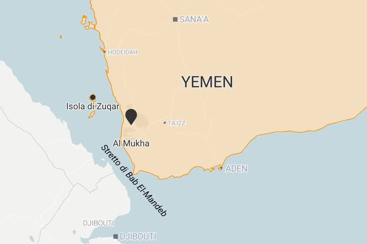
There war in the Middle East Between United States And Iran is moving towards a new chokepoint strategic, it Strait of Bab el-Mandeb: the Houthis, the Yemeni armed movement supported by Iran, have taken the check of the historic port city of Mocha (located less than 80 km from the strait) and launched attacks against the strategic ones Hanish Islandsin the Red Sea, pushing Saudi-backed Yemeni government forces southward to Dhubab, a city directly across the strait, just across the island of Perim.
The Houthis’ strategy is clear: whoever controls the Yemeni coast overlooking the Red Sea is strengthening their own taken on one of the busiest sea passages and disputes of the planet, the Strait of Bab el-Mandeb, which after the blockade of the Strait of Hormuz has acquired even more importance.
Last July, the group had already declared a naval blockade against Saudi Arabia (the world’s largest oil exporter) and Houthi dominance of the canal it would isolate further i oil producers of the Gulf from their main shipping routes. Also due to the worsening of the attacks between the USA and Iran, the price of oil soared above 105 dollars a barrel, with Saudi crude oil production collapsing by 1.9 million barrels a day, reaching 6.238 millionthe level lowest since 1990.
If both straits (Bab el-Mandeb and Hormuz) were to be closed at the same time, approximately 30% of global oil transported by sea it would get stuck. The problems, however, do not only concern oil: the Strait of Bab el-Mandeb also passes through Approximately 10% of global tradewith numerous containers arriving from China, India and other Asian countries and headed towards Europe.
It must be said, however, that control of the city of Mocha it’s not enough to completely control Bab el-Mandeb (which also depends on Djibouti and Eritrea and on the international naval presence), but it could have important repercussions on navigation risks across the Strait.
What is the Bab el-Mandeb Strait and what is it like?
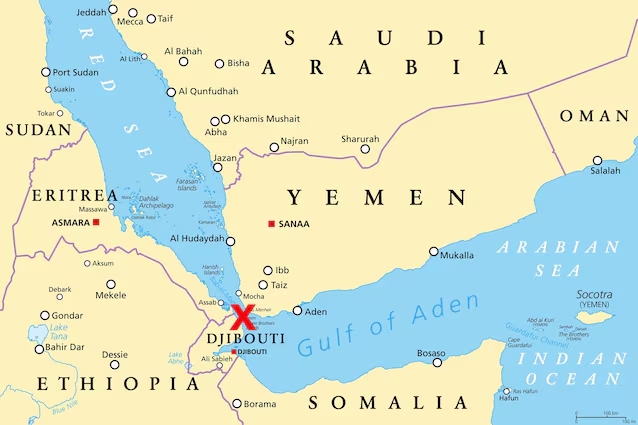
The Strait of Bab el-Mandeb is located at the southern end of the Red Seastuck between two continents. On the one hand there is Yemenon the Arabian Peninsula, on the other there are Djibouti and Eritreaon the African coast. This maritime bottleneck represents the point where the Red Sea connects to Gulf of Aden and, from there, to the Indian Ocean. It is located on the opposite side of the Arabian Peninsula from the Strait of Hormuz, the other major passage that ended up at the center of the war between the United States and Iran.
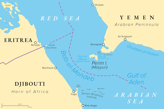
The most striking thing is his dimensions. At its narrowest point the strait measures about 18 miles (approx 29 kilometers) and is naturally divided from the Yemeni island of Perim (Mayyun, in Arabic) in two channels: the international maritime traffic it mainly passes through the canal westernapproximately wide 26km and deep about 200 meters. The canal easternhowever, which reaches just 30 meters deep and 3 km wide, is used for local traffic and small boats.
Within the arm of the sea some islands of volcanic origin appear and the maximum depth is approximately 300 metres: it is no coincidence that in Arabic Bab el-Mandeb means “Gate of Tears”, a nickname due to the notoriously treacherous navigation conditions in this stretch of sea. Further north are the Hanish Islands, located between the ports of Hodeidah And Mocha. The Houthis actually already control Hodeidah, which they have used as a base for their campaign of attacks against trafficking in the Red Sea.
According to a Yemeni military source, in addition to Mocha the Houthis also conquered the island of Zuqar, a south of the Red Seaafter missile attacks and a land assault conducted with the aid of boats carrying fighters.
Why such a small strait matters so much (even for Europe)
Such a narrow and busy maritime passage is defined in jargon as a “chokepoint”, that is, a bottleneck, a bottleneck through which an enormous share of world trade is forced to pass and which, for this very reason, becomes a weak point.
Bab el-Mandeb is the entrance door southern of Suez Canal, which connects the Red Sea to the Mediterranean. To be clear, it is the junction that allows a goods and raw materials to travel directly between Asia and Europewithout having to circumnavigate the whole of Africa via the Cape of Good Hope. From this stretch, passes the 12% of world trade.
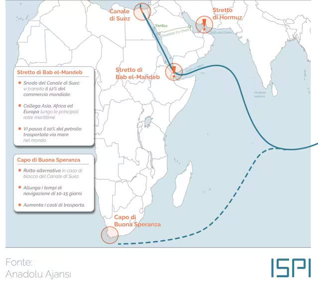
In addition to goods, however, oil and fuel also pass through Bab el-Mandeb heading from the Gulf to the Mediterranean: now that the Strait of Hormuz is closed, Saudi Arabia has in fact tried to redirect its oil exports towards the Red Sea. More specifically, Riyadh pushed its East-West oil pipeline (the so-called Petroline) at full capacity, redirecting the crude oil from the eastern fields to the port of Yanbu on the Red Sea. To ensure that Saudi crude oil reaches Asian countries, however, ships must necessarily pass through the strait in question.
The numbers help to understand its importance. According to what was reported by the US Energy Information Agency (EIA), the volume of oil in transit through the Strait of Bab el-Mandeb went from 5.7 million barrels per day in 2020 to well 9.3 million barrels per day in 2023. After the start of the Houthi attacks in the Strait, the transit of crude oil through this checkpoint decreased, dropping to 4.1 million barrels per day in 2024 (about 5% of oil traded by sea globally) and to 4.2 million barrels per day in the first half of 2025.
The problem is that, in the event that this passage were blocked, the ships would be forced to deviate around the Cape of Good Hopeat the southern tip of Africa, adding weeks of travel and enormous costs to a route that would otherwise be linear.
And this situation has already occurred in the past: with the Houthi attack campaign starting at the end of 2023, logistics and energy giants diverted their ships away from the Suez Canal, making them circumnavigate Africa. The result was immediate: Skyrocketing transportation costs and much longer travel times. And more time and money to move goods means, at the end of the chain, higher prices and inflationary pressures which reach European consumers, as the cold season approaches.
