Thanks to a progressive failure of thehigh pressurethe phase of intense heat that has hit Italy and Western Europe in recent weeks is now about to loosen its grip: for today, July 1st, however, strong thunderstorms and precipitation in various Italian regions. The Civil Protection has in fact issued orange weather alert in Lombardy and alert yellow in 14 regions – including Emilia-Romagna, Abruzzo, Tuscany, Molise, Puglia and Sicily – due to storm risk and hailstormslocally also strong.
There hail it has always existed, it is nothing new. However, what we ask ourselves more and more often is: “In Italy the destructive hailstorms?” The answer is Yes. This isn’t just an impression amplified by social media: Second data from the European Severe Weather Databaseover the last twenty years reports of destructive hailstorms in Italy have tripled, due to the increasingly intense heat. Our country, in fact, is the one that suffers most from this increase, but what is behind all this?
How hail is formed
To understand how hailstones can become huge, we must first take a leap into the cloud that produces them, i.e. the cumulonimbusthat vertical cloud which, seen from afar, appears like a white cauliflower. The cumulonimbus is the thundercloud, with vertical developmentwhich can extend upwards to 12-15 thousand meters in height. Two currents of air traveling in opposite directions collide inside: a warm and humid one that rises from bottom to top (updraft) and the other colder one which descends towards the ground (the so-called downdraft).
The hailstone originates at the bottom of the cloud and is initially nothing more than a tiny droplet of water or a needle of ice. Under normal conditions the force of gravity would push it downwards, but what happens if the rising current is decidedly violent? This acts like a fan pointed towards the sky: it takes this small drop/grain and pushes it upwards, precisely where there are very cold temperatures in the cloud, even below -20°C.
At that moment the grain, still small and harmless, meets “supercooled” water (i.e. water that is still liquid despite the freezing thermal values), which freezes around it. The grain then falls downwards, but the violent currents push it back upwards, thus accumulating another layer of ice. The stronger the upward current, the more it manages to keep the heavy grain in suspension, making it become bigger and bigger, until gravity wins over every external factor again and the grain falls to the ground.
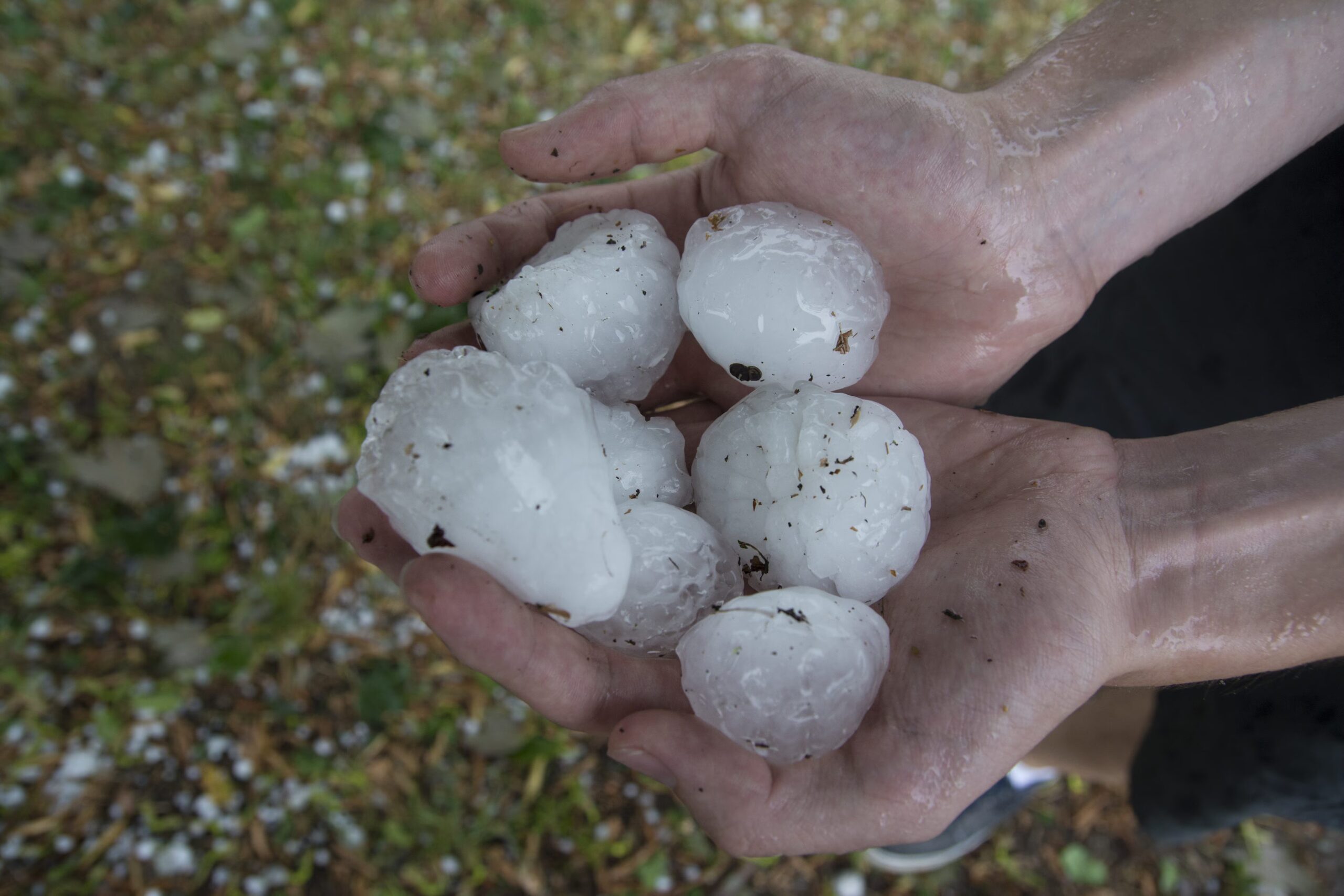
Ever larger and more destructive grains
Well, this is the process it takes to form the hail which, as we said, it is always existed. The key question is: “if the process is the same, what has changed?”. The strength of these currents within the cloud has changed, therefore as explained, the stronger they are, the more the grain tends to enlarge due to its countless upward journeys.
The force in atmospheric phenomena is given by a greater energy. Today we often hear that average temperatures are 1 or 2 degrees above average almost constantly. At first glance one might think: “Okay, what could it be one or two degrees higher? If I have 21 or 22°C in my house, I almost don’t notice it”. At a meteorological level and on a large scale, an increase of even just one degree is not at all nonsense: it is an enormity. In physics, in fact, the warmer the air, the more capable it is of taking in water vapour (to be precise, about 7% more humidity for each degree of heating). This means that the column of air around it has transformed into a huge boiling sponge.
In weather charts this potential energy is carefully observed before a forecast and is called CAPE (Convective Available Potential Energy). High CAPE values indicate that it is present in the air an important quantity of “thermodynamic fuel”ready to explode as soon as the spark arrives, and by spark we also mean a small gust of cooler air at altitude.
Italy has a decidedly complex orography and this plays a very important role. Let’s start from Po Valley. First of all, being a lowland enclosed between the mountains, it accumulates a lot of heat but above all it is often found halfway between the cooler air masses that flow over northern Europe and the warmer ones that rise from more southern latitudes.
The cooler air currents make important “jumps” in direction and intensity (wind shear). In some specific areas, real ones are created convergence zones in the lower layers, where the winds collide and whip upward. This is why there are areas that are historically more subject to devastating hailstorms than others. Just think of the Vercelli area in Piedmont or the Pordenone area in Friuli-Venezia-Giulia, and it is precisely in the latter that the history of meteorology met reality: the record for the largest hailstone ever recorded in all of Europe belongs precisely to this area, specifically to Azzano Decimo. On July 24, 2023, a block of ice with a diameter of 19 centimeters was collected!
The role of the Mediterranean Sea in hailstorms
So far we have only talked about the mainland, but it is right to say a few words about the Mediterranean Sea too. This basin is experiencing a warming at twice the rate of the global averageshowing values belonging to tropical latitudes. This marine heat not only affects the Po Valley, but creates real monsters directly on the coasts and coasts. In recent years, in fact, we have witnessed a marked increase in the number of supercells of a maritime naturephenomena that were almost totally unknown on this portion of Earth until a few years ago.
A perfect example is the Liguriaa very mild region where from 2022 to today there have been more than 4 supercells hit the coast. The most intense and devastating was the one that hit Sestri Levante in August 2022 with hailstones with a diameter of 5 centimeters and winds of up to 115 km/h, a phenomenon which, among other things, anticipated the arrival of a powerful “derecho” responsible for numerous damages on Corsica, upper Tuscany and Triveneto.
What awaits us in the future? This is always a difficult question to answer, as the warming trend is confirmed but exceptions and nature’s variables are always around the corner. It is not certain that it will rain more in the future, in fact there could even be fewer rainy days; the problem is that the atmosphere, being permanently warmer, will always have more fuel available for atmospheric phenomena and, consequently, the probability that a summer storm transforms into a supercell with medium-large sized hail will be much higher, both on the mainland and along the coasts.