
Today at 9:05 (local time), a strong earthquake of magnitude 7.1 hit the Chinese region of Tibet, in Dingri county near the Himalayan region, causing at least 95 victims And 135 injured – although their numbers may soon rise. The earthquake shock was also distinctly felt in Nepal and in India northern and according to the authorities its epicenter would be located within the Tibetan plateau, approximately 80km from Mount Everest. As reported by the main international press agencies, there are currently more than 1000 homes damaged in the area of the epicentre, strong tremors were felt as far away as Kathmandu, the Nepalese capital, and it seems that also in 80 km away collapsed roofs and damaged roads were reported. Overall it is estimated a grade VIII on the Mercalli scale (MCS), equivalent to partial ruin of some buildings and isolated victims. At the moment, over 1,500 firefighters and rescuers are employed to recover the missing, while the residents of the area have been evacuated.
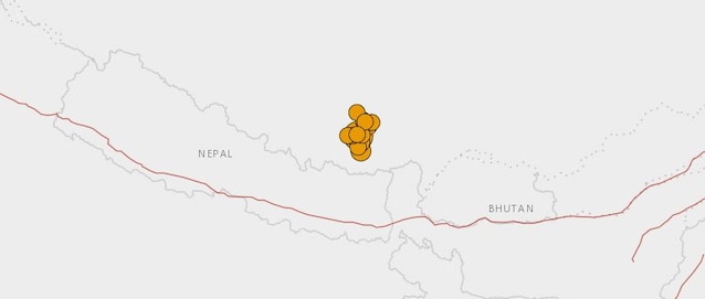
As also confirmed from the USGS, the earthquake in question was followed by a seismic sequence, characterized by about ten tremors with magnitude between 4.0 and 5.0 – as also represented in the image below.
But what caused the earthquake? The Himalayas are a very active area from a seismic point of view: over the last century, three very violent earthquakesrespectively of magnitude 8.0 (in 1934 and 1946) and of 8.3 (in 1950). These, as well as today’s one, are linked to the geological context: it is acollision area between the Indiana plate and that Eurasian. Over time, this continuous push has given rise to numerous active fault systems which, unfortunately, can sometimes give rise to violent earthquakes.
To learn more, here is a video ad hoc on the location of earthquakes in the world:
