It is being mitigated exceptional bad weather which has hit Sicily, Sardinia and Calabria in recent days as a result of the storm Harryeven if thered alert of the Civil Protection for today and tomorrow. In the last few hours the minimum of the depression is moving eastwards and the instability is rotating over the Tyrrhenian Sea and other sectors of the South, thus allowing a gradual improvement in the atmospheric conditions in the areas affected by Harry between today and tomorrow.
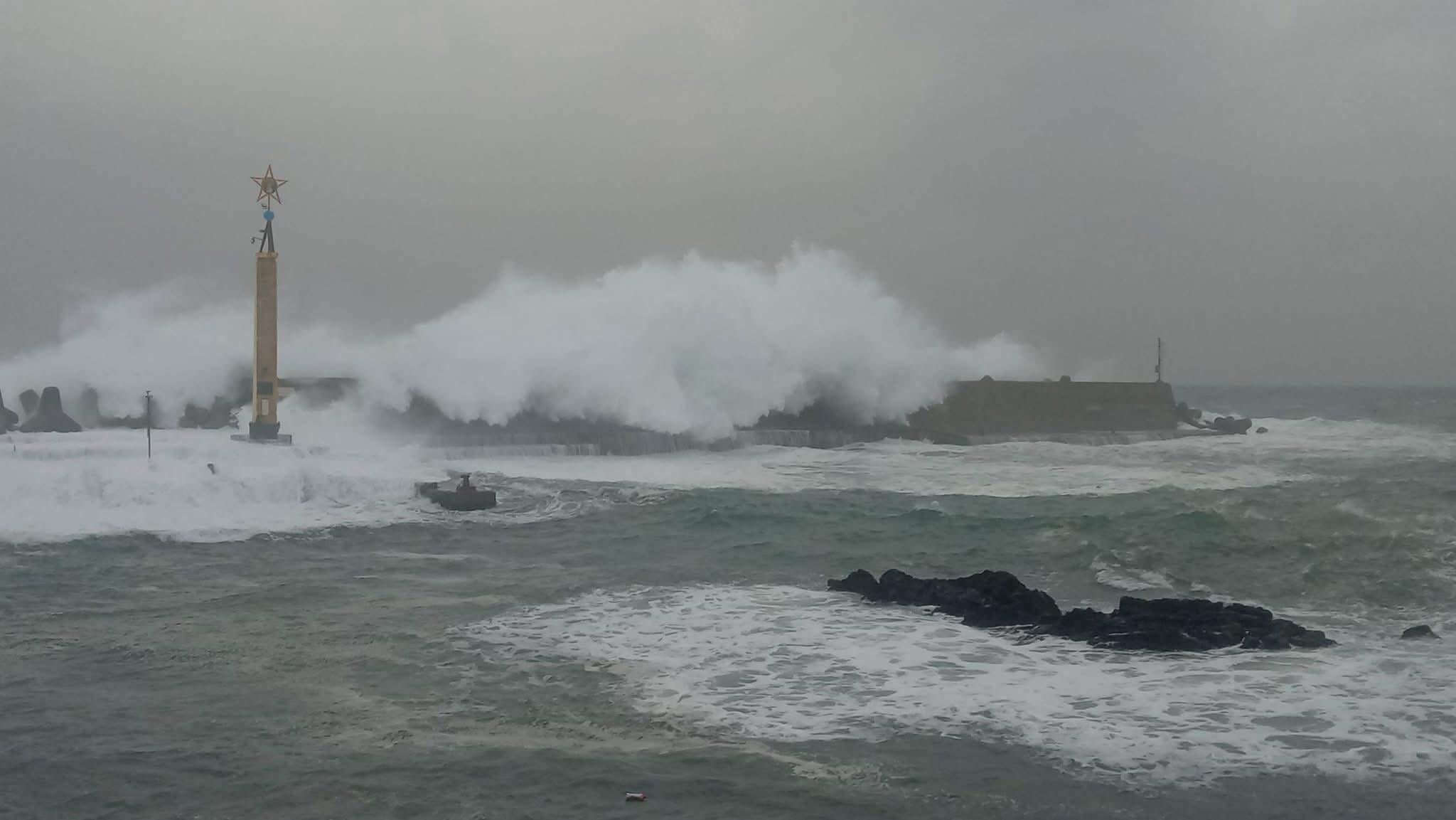
In addition to torrential rainfall, which also reached i 600 millimeters in the Etna area (to which is added below 1 meter of snow at altitude), and stormy winds with gusts of wind which have also surpassed the 120 km/h in north-eastern Sicily (just below the intensity of a category 1 hurricane), the ones that struck above all were the destructive storm surges which hit various Sicilian, Sardinian and Calabrian coasts, with waves reaching the record of 16 meters high and which caused extensive damage.
We are therefore talking about most intense storms in recent years in Southern Italy and of waves that have surpassed historical records in this area of the Mediterranean, as visible in the video of Francesco Albino. In Catania, dozens of families they were evacuate from homes along the seafront.
From a meteorological point of view it was storm waves (storm surge in English), a phenomenon that is typically associated with tropical or extratropical cyclones such as the so-called TLCs (Tropical-Like Cyclones). Harry is not a phenomenon of this type (he has the structural characteristics of one extratropical storm), but it still had an intensity comparable to that of an extratropical cyclone.
Storm waves happen when we have simultaneously low atmospheric pressure and strong winds: in Harry’s case we had a deep depression low (below 1000 hPa) and a strong pressure contrast with an anticyclonic promontory in the Balkan area, which generated the stormy winds. When low pressure is above the sea, the atmosphere “presses” the surface of the water more weakly, which is therefore free to rise; if we add strong winds to this, a wave motion which can produce waves even several meters high.
These waves are not necessarily generated on the coast, but can also form in open sea. Here the storm – especially if the wind acts for a particularly long time – can generate a system of moving long waves capable of propagating for hundreds of kilometers (or thousands, if it happens in the ocean), until it hits the coast with a rather high regular period, generally around 10 seconds (even 20 seconds in the oceans). This system of waves generated in the open sea by a storm and which forcefully arrive on the coast is called in technical jargon swell and is well known to surfers for example. The higher the sea surface is capable of generating wave motion under the action of the wind (a parameter called fetch), more energy is transferred to the resulting waves which will consequently be louder and more destructive.
Well, now we have all the elements to understand why the storms of recent days have been so violent. The height and range of the waves are mainly determined by three parameters: the wind speedthe wind durationand the fetch. In the case of Storm Harry all these parameters were very high: strong winds, the blocking of the storm which allowed the wind to act for a long time, and a very vast sea surface exposed to the wind. The combination of all these conditions, to which must be added the physiological increase due to low pressure, has led to theexceptionality of storm waves which mainly affected Sicily, but also Sardinia and Calabria.
What happened above all in Sicily, but also in Sardinia and Calabria, was therefore essentially the same swell with oceanic wave motion characteristics: Significant wave heights (i.e. the average height of the highest 33% of waves) ranged between 5 meters and 9 meterswith an effective maximum recorded of even 16 metersand a period of approx 10 seconds between one wave and another. All this – we remember – must be added to the torrential rainfall and stormy winds that made extreme this wave of bad weather in Sicily, Sardinia and Calabria.
We conclude with a clarification: at the same time as all this, the province of Messina is currently affected by a seismic sequence with earthquakes that have reached quite high magnitudes. It is good to specify, however, that it is one unfortunate coincidence: there is in fact no correlation between seismic activity (remember that Sicily has always been an area at high risk of earthquakes) and meteorological activity. If it is true that underwater earthquakes can produce anomalous waves and tsunamis, the waves that hit Southern Italy are storm waves generated by Storm Harry.